Tidal reference
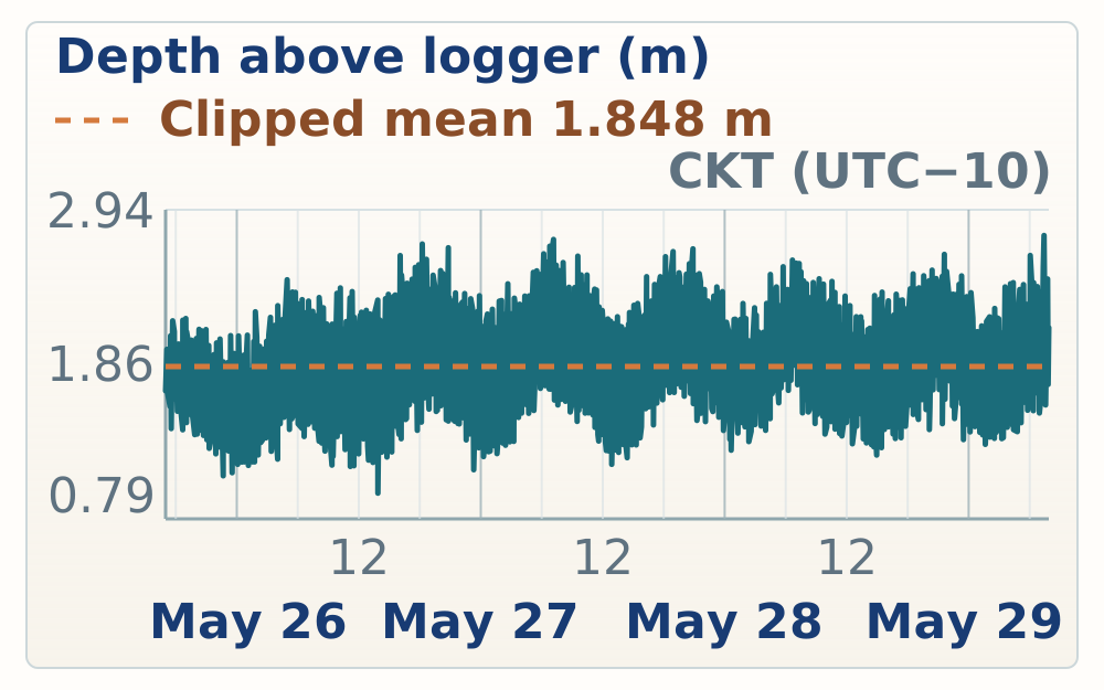
Atiu tidal reference
- Tidal datum
- 14.231 m
- GPS height
- 15.701 m
- Mean water depth
- 1.848 m
- GPS offset
- 3.317 m
Saturday, 2026-05-23
Flight timing
Schedule lock
Proceed from Atiu Airport to the Chambers before heading to Atiu Villas; accommodation host handoff still needs confirmation.
Tidal reference
Site evidence
Arrival-day work covered tide-gauge setup, first reconnaissance stops on the Atiu reef benches, South Point observations, and the harbour tide-gauge datum tie. Observation times were matched to the nearest GPS fixes in the raw field log.
14:22-14:25
Overview
14:22 | ATIU-20260525-RN-015
Three tide gauges programmed at 30 s intervals: one land reference and two water deployments planned, including harbour and possibly beach.
Programming three tied gauges at 30 second intervals, one to stay on land, two to go in the water. Maybe one of the harbor and one, hopefully today. Near the beach.
Atiu tide gauge programming
Three tide gauges programmed at 30 s intervals: one land reference and two water deployments planned, including harbour and possibly beach.
14:25 | ATIU-20260525-RN-014
One tide gauge set high inside house/villa number five.
One tide gauge set inside house number five up high.
Atiu Villas land tide gauge
One tide gauge set high inside house/villa number five.
15:14
Overview
15:14 | ATIU-20260525-RN-013
Beach reef bench about 1-1.5 m above lagoon, possible early Holocene highstand; lagoon level may be wave-driven, not representative of MSL.
Taking a tour with Roger right after we got in? Um, took us down to a beach where we walked through. Um. A fully sort of intact. Coral reef. That. Sits above a sort of tabular bench that maybe the early Holocene. High stands, maybe a meter meter and a half above the Lagoon. Interesting, the Lagoon is. Uh, potentially. Flooded entirely by wave action, so the water level is not actually representative of means sea level. Something we want to think about with our tie gauges.
First reef bench after arrival
Beach reef bench about 1-1.5 m above lagoon, possible early Holocene highstand; lagoon level may be wave-driven, not representative of MSL.
15:43-15:49
Overview
15:43 | ATIU-20260525-RN-012
Road-end South Point reef has high coral diversity in growth position; lower bench is about 0.5 m above lagoon. Origin remains unclear.
The South Point. Um, we parked at the end of a little road that came off the main road with Roger. And just walking around. It's another sort of beautiful, intact Reef. So much choral diversity. Everywhere you look is a coral likely and growth position. But within a few meters. Five species, easily identifiable. Again, like the other location. There is a lower bench. Kind of half a meter above the Lagoon. Maybe the? Corals in that lower bench look a bit more like breccia, but from standing far away and sort of looking at them. Uh, they're sort of things that look like possum Opera. These sort of branching? Towards corals that are growing in a distribution. Every two meters or so away from each other. Similar how we see we saw in Hawaii in the Lagoon itself, so I don't know if this is. Different sea level high staff is an early Holocene, or is it all part of the same Macataya? Likely less interglacial sequence. Uh, there's no obvious internal stratigraphy of the reef and sort of just quick glance. And the top is just as diverse as the bottom.
South Point intact reef bench
Road-end South Point reef has high coral diversity in growth position; lower bench is about 0.5 m above lagoon. Origin remains unclear.
15:45 | ATIU-20260525-RN-011
Smooth-weathering small-coralite coral stands out from the outcrop and may be a useful dating target.
To add to that last note in a few places. Now, I've seen this Coral, an incredibly small corallites. So, it's weather is looking very smooth. It kind of stands out with respect to the rest of the outcrop. Um. It reminds me. Of Palmata. The way Palmetto looks in outcrop. I'm curious if that will be a good Target for dating.
South Point small-coralite dating target
Smooth-weathering small-coralite coral stands out from the outcrop and may be a useful dating target.
15:47 | ATIU-20260525-RN-010
Upward-branching coral protrudes from makatea vegetation; possible upward change in limestone/coral texture without clear rubble/species break.
Just snapped a photo of one of these upward branching. I'm calling pasta law for a type corals. Like sticking up out of the vegetation at the top of the makatea. It really seems like. As far as I can see upwards, there's a change in like the kind of. Uh, Coral are the kind of limestone that we're looking at. No obvious change in species or. Into Rubble.
South Point branching coral photo
Upward-branching coral protrudes from makatea vegetation; possible upward change in limestone/coral texture without clear rubble/species break.
15:49 | ATIU-20260525-RN-009
Lower surface is smoothed/polished and locally braided, likely by seasonal sand movement.
The lower surface is sort of polished. It's kind of a braided and smoothed in places. And I sort of suspect it's just from sand seasonally. It was storms sort of moving in and out. Roger had mentioned that there are times of the year. Where sand builds up down here in times of the year. Where it gets. Pulled back out to see.
South Point polished lower surface
Lower surface is smoothed/polished and locally braided, likely by seasonal sand movement.
16:13
Overview
16:13 | ATIU-20260525-RN-008
Pocket beach with tabular beachrock/reef slabs thrown into the modern beach and mixed with older reef boulders.
Move to the leeward side. And stopped at a small pocket Beach. Uh, the same sort of reef structure above, but really good examples of tabular class Beach Rock. Thrown up on top of each other. Thrown up into a modern beach. Mixed with classes of Boulders from. The older wreath.
Leeward pocket beach clasts
Pocket beach with tabular beachrock/reef slabs thrown into the modern beach and mixed with older reef boulders.
17:01-17:30
Overview
17:01 | ATIU-20260525-RN-007
Gauge on rock with white float in sand patch at right side of harbour facing ocean; re-measure concrete offset on return visits.
Tide gauge attached to a rock at the harbor. The Rock has a small white float. Um, it's in the middle of a sand patch on the right side of the harbor as you're coming down the road facing the ocean. Uh, we plan to. Measure the height of the concrete and the offset with the top of the water and use that with a tide gauge measurement to get mean tide level, we'll re-measure the concrete anytime we pass through here over the next five days.
Harbour tide gauge location
Gauge on rock with white float in sand patch at right side of harbour facing ocean; re-measure concrete offset on return visits.
17:12 | ATIU-20260525-RN-006
Avoid water-height timing uncertainty; measure gauge position directly up to the concrete/GPS point.
Previous plan for measuring the tide gauge to the water height to the concrete height doesn't really work because the water height moves, and we don't have the exact. Timing the 30-second interval of the tide gauge, so we don't want to introduce that extra uncertainty. So, Roger's going to get in the water. We're actually going to measure the position of the tide gauge up to the top of the concrete, where we'll measure our GPS point. Okay, so?
Tide-gauge measurement plan revised
Avoid water-height timing uncertainty; measure gauge position directly up to the concrete/GPS point.
17:14 | ATIU-20260525-RN-005
Follow-up method: lower weighted string from wall to gauge, mark at concrete, and compare length against in-water measurement.
Plan for when we come back might be to attach a weight on a string and lower the weight down from the wall until it hits the tide gauge, and then we'll pull in the string marking where it was at the concrete, and then we'll actually just measure the length of the string and see how that compares to Roger's measurement in the water.
Weighted-string tide-gauge check
Follow-up method: lower weighted string from wall to gauge, mark at concrete, and compare length against in-water measurement.
17:23 | ATIU-20260525-RN-004
Roger measured from tide gauge to concrete/wall: 3.32 m and 3.315 m repeat measurements using a 2 m ruler plus 1.32/1.315 m.
Roger got in the water and we measured directly from the tide gauge to the base of the concrete. It's a harbor. Um, the first time we did it. We got three meters and 32 centimeters the second time we did it. We got three meters and 31 and a half centimeters. Uh, it was two meter full ruler sighted to the wall with Roger in the water. And then measure down from the top. With Roger putting his finger on this side, it's spots. It was 68 and 68 and a half. Um, that was the additional measurement onto the two meters. The ruler wasn't inverse, so this is where the 132 or 131 and a half comes from.
Harbour tide gauge to concrete measurement
Roger measured from tide gauge to concrete/wall: 3.32 m and 3.315 m repeat measurements using a 2 m ruler plus 1.32/1.315 m.
17:29 | ATIU-20260525-RN-002
GPS setup uses zero pole offset; compare control points only after accounting for antenna height. Tie heights back to tide-gauge water level.
Right now, the tie gauge, I mean, sorry. The satellite is set with zero pole offset the GPS. We're going to keep that the entire time. Ultimately, everything will get referenced back to the water level from the tide gauges. Um. Where this may be an issue is if we have the? Gps, measuring someone else's control point. We need to remember that we did not put the offset of the antenna. Into the measurement before we compare. So, if we're suddenly two meters? Too high, then it's just the offset.
Tide-gauge datum and antenna offset note
GPS setup uses zero pole offset; compare control points only after accounting for antenna height. Tie heights back to tide-gauge water level.
17:30 | ATIU-20260525-RN-001
Keep GPS pole offset at zero for the trip; if heights jump, check whether an offset was programmed in the phone/GPS.
It's really important. We don't change that over the trip, so if suddenly everything seems too high or too low, we need to. See if someone programmed an offset in their phone.
GPS pole-offset consistency check
Keep GPS pole offset at zero for the trip; if heights jump, check whether an offset was programmed in the phone/GPS.
| Site ID | Height (m above mean sea level) | Vertical position | Vertical accuracy | Vertical precision | Points | Notes |
|---|---|---|---|---|---|---|
| Harbor base station | 1.441 m | 15.672 m | 0.089 m | 0.005 m | 200 | Taunganui Harbor base station for reoccupation. |
| Harbor base station repeat occupation | 1.500 m | 15.731 m | 0.078 m | 0.005 m | 500 | No note recorded. |
| Tide gauge | 1.456 m | 15.687 m | 0.106 m | 0.016 m | 200 | Dock above tide gauge. Reminder: Pole height is set to 0m. Must add pole height to measurement. |
| Tide gauge | 1.484 m | 15.716 m | 0.065 m | 0.004 m | 200 | 132+200 =332cm tide gauge to dock surface |
Tidal reference
Site evidence
May 26 built the first detailed Atiu framework comparison at HS101 Matai and HS102 Tuaroa Beach. Field observations separate lower, large growth-position branching coral from upper Diploria-like, honeycomb, smooth, and encrusting coral forms, then tie those facies observations to HS101 samples A-G, GCPs, and drone passes. The day also records rough-wave limits at HS102, sample control on several coral morphotypes, and a final smoother bench check whose possible Holocene erosional meaning remains provisional.
09:53-10:54
Overview
09:53 | ATIU-20260526-RN-053
After the mayor's office meeting, the team reviewed rough-wave conditions at Matai and planned to walk the outcrop looking for Woodroffe's two reef units, a sand sheet, coral types, and fossils.
After a successful meeting with the mayor with a very warm and welcoming. Are the deputy mayor? Roger took us down to matai. We sat as a team and sort of discussed some of the observations and game plan for the day. Uh, waves are very rough and. Uh. They actually crash pretty high up on the beach, so almost lost some bags. The plan right now is to sort of walk the outcrop and try and identify some of the features that Woodroffe. Mention just two different layers a sand sheet between them and at the same time. Also, get everyone a chance to sort of figure out what kinds of corals we're seeing. What kinds of different fossils? Um, to build some observational basis for the rest of the trip.
Field plan at Matai
After the mayor's office meeting, the team reviewed rough-wave conditions at Matai and planned to walk the outcrop looking for Woodroffe's two reef units, a sand sheet, coral types, and fossils.
09:54 | ATIU-20260526-RN-052
Upper roadside coral has feather-like upward corallite ridges about 0.5-1 mm apart and looks Diploria-like or brain-coral in end-on view.
Observation of a coral. And sort of the upper part of its high near the walk, the entrance near the road. Take. I took a picture with my. Tg5. And. The corallites sort of grow upwards in a feather pattern. Uh. You know, maybe a millimeter to half a millimeter apart? It kind of looks like a Diploria-like coral when I see it from from end on. So some kind of brain coral. Pattern to the ridges between four lights.
Upper brain-coral form
Upper roadside coral has feather-like upward corallite ridges about 0.5-1 mm apart and looks Diploria-like or brain-coral in end-on view.
09:58 | ATIU-20260526-RN-051
The lower unit is dominated by in situ upward-branching coral colonies several meters across, with branches up to about 1 cm diameter and corallites around 2 mm wide.
The lower part of this unit. Uh, is dominated with a branching Coral that I'll describe now. The branches are. Maybe a centimeter? At at maximum should? Diameter. The colonies can be several meters across in growth position. I took a picture with. Uh, with my tg5. Uh, with a ruler showing that. Um, the corallites themselves. When you see the branches head on you, it looks like a bunch of tiny little rings. There, maybe? Two millimeters across very evenly spaced. I can't quite tell if they have the characteristic end on corallite that you would see in a Acropora. But some kind of upward branching. Colonial Coral definitely in situ! Um, and can be quite large.
Lower branching coral
The lower unit is dominated by in situ upward-branching coral colonies several meters across, with branches up to about 1 cm diameter and corallites around 2 mm wide.
10:01 | ATIU-20260526-RN-049
The same branching coral colony is much larger than first noticed, extending tens of meters down the beach.
Still describing that last Coral. As I stepped back, I realized that the colony is actually. Uh, maybe tens of meters across. It extends all the way down the beach. Um, as. One massive Colony. Uh, and I took another picture, and that only covers about half of it. There's more that extends down towards the beach.
Branching colony scale
The same branching coral colony is much larger than first noticed, extending tens of meters down the beach.
10:01 | ATIU-20260526-RN-050
Matching massive upward-branching coral occurs on the other side of the groove, suggesting repeated or laterally extensive colonies.
Still describing that same Coral. I don't know if it's a different Colony. But um, the other side of the groove. There's another massive colony of the same kind of coral looks the same, same upward branching.
Branching coral across groove
Matching massive upward-branching coral occurs on the other side of the groove, suggesting repeated or laterally extensive colonies.
10:05 | ATIU-20260526-RN-048
Two corals above the branching network show honeycomb-like corallite chambers: one with roughly 7 mm chambers and another with smoother 1-2 mm chambers.
I'm looking at two new corals in a unit above the large branching Network. I took a bunch of pictures of these corals. They're side by side, which helps. Sort of key in on the observational differences. The one on the right? Sort of, uh? Circular, maybe 70 millimeters, 0.7 centimeter. corallite Chambers. All sort of lined up like a bunch of circles next to each other, like a honeycomb. And in cross section, you can see. Uh, a pretty distinct vertical. Uh, Network separating this sort of little horizontal Chambers. Coral is in growth position. Next to it is a coral with extremely small. Uh, kind of the same pattern, so we have these. Vertical. Rides with. Horizontal. Chambers, but everything's just much smaller when you look in Dawn. You can see that same sort of a bunch of circles next to each other honeycomb, but these are about a millimeter. Maybe two millimeters in diameter? The smaller corallite Coral. Weather is very sort of smoothly to touch. There's the other one is a lot more. Some holes of jaggedness coming out of the rock.
Honeycomb corals above branchers
Two corals above the branching network show honeycomb-like corallite chambers: one with roughly 7 mm chambers and another with smoother 1-2 mm chambers.
10:12 | ATIU-20260526-RN-047
Smooth or encrusting coral wraps around high topography and is heavily bored by Christmas tree worms or attached organisms, with dense carbonate cement nearby.
The smooth Coral seems to sort of wrap around. little nubs of high topography, maybe encrusting along the side. So also. At least in the location I just photographed. Really heavily. Punctured by Christmas tree worm. Or some other kind of attaching. Organism took a bunch of pictures of these holes that sort of penetrate through the coral. Maybe at the top of some of these, there are. Uh, sort of big encruster colonies. Lots of super dense carbonate cement and. Just kind of looks like a jumbled mess. Uh, reminds me of things that we saw in the Barbados Reef.
Smooth encrusting coral
Smooth or encrusting coral wraps around high topography and is heavily bored by Christmas tree worms or attached organisms, with dense carbonate cement nearby.
10:18 | ATIU-20260526-RN-045
The upper outcrop is almost entirely coral framework, with small-corallite coral surrounding larger honeycomb coral colonies around 40 cm across.
The upper part of this outcrop is, I mean, almost everything is Coral. It all seems like part of the framework. A lot of this really small, corallite Coral. I just took another picture. Of this side-by-side relationship with the other sort of larger honeycomb Coral. The honeycomb Coral. Is maybe in this case, 40 centimeters across, and I've seen a lot of similar sizes. Um, but it's sort of sitting in many, many meters of this finer. coral, where you can't really see where it starts and ends.
Upper outcrop framework
The upper outcrop is almost entirely coral framework, with small-corallite coral surrounding larger honeycomb coral colonies around 40 cm across.
10:18 | ATIU-20260526-RN-046
An intermediate honeycomb coral has circular corallites around 3 mm across, between the larger honeycomb forms and the finer coral mass.
There's another Coral here that has. This sort of um? Honeycomb type look this? Circular circles next to circles. Uh, but in this case, the corallites if I'm using that word right, or maybe three millimeters across. So, it's this. Intermediate between the really large ones that I previously talked about and the extremely fine grained coral mass that makes up most of the outcrop.
Intermediate honeycomb coral
An intermediate honeycomb coral has circular corallites around 3 mm across, between the larger honeycomb forms and the finer coral mass.
10:19 | ATIU-20260526-RN-044
The intermediate coral appears in patches roughly 10-20 cm across.
In general, the coral I just described is smaller, so I see it in patches of 10 to 20 centimeters at a time.
Patchy intermediate coral
The intermediate coral appears in patches roughly 10-20 cm across.
10:20 | ATIU-20260526-RN-043
Large branching framework corals are absent from the upper unit but recur near beach-level exposures, suggesting a vertical or lateral reef-position control.
Pretty consistent feature of the outcrop in general. Is that the? Branching, large framework corals I talked about early on. I'm not really present in this upper unit. It could be that they were only present in that initial Groove that we walked down. And maybe in another Groove. I would see them again, but I see them every time I get down towards the beach. And when I'm up a meter to, I don't really see them very much.
Upper unit lacks large branchers
Large branching framework corals are absent from the upper unit but recur near beach-level exposures, suggesting a vertical or lateral reef-position control.
10:22 | ATIU-20260526-RN-042
Another Diploria-like coral was photographed for comparison with the earlier brain-coral form and its chamber or corallite scale.
Just took a picture of another Diploria-like coral. I think it's very similar to the one I first described. The weathering is a little bit different here. I may want to check in photos if the. Scale is the same sort of the the size of the chambers of the. Um, width of the corallites as the one I described and photographed earlier.
Diploria-like comparison photo
Another Diploria-like coral was photographed for comparison with the earlier brain-coral form and its chamber or corallite scale.
10:24 | ATIU-20260526-RN-041
Small pockets of branching coral occur higher up, but colonies are only about 40 cm wide rather than massive.
I'm trying to see a few pockets of the branching Coral or at least something that looks very similar to it higher up, but they're not the massive colonies that I saw below. Just took a picture of one that sort of angled away from the beach today. But the whole colony itself is maybe 40 centimeters wide at the at the widest.
Small high branching pockets
Small pockets of branching coral occur higher up, but colonies are only about 40 cm wide rather than massive.
10:26 | ATIU-20260526-RN-040
Smooth-coral weathering may expose circular corallite walls in positive relief, possibly a top-end view of the finer smooth form.
I'm taking a close look at. Coral that looks a lot like the one that I've been calling the smooth coral. Uh, maybe this is just a different weathering pattern or expression. I just took a few photos where you can really see. These sort of circular? corallites walls. Uh, kind of poking out with sort of a positive relief. I can't quite tell if this is the same just sort of the top end view of the one that looks incredibly fine from the side.
Smooth coral weathering
Smooth-coral weathering may expose circular corallite walls in positive relief, possibly a top-end view of the finer smooth form.
10:27 | ATIU-20260526-RN-039
Massive branching colonies recur toward the beach at the same location, implying the pattern is not limited to the first groove.
At the same location as you go down. Towards the beach. We find the same massive colonies many, many meters across the branching corals. So it doesn't seem like it's necessarily connected. The groove we were in, and it might be sort of a vertical or lateral position of the reef.
Beachward branching recurrence
Massive branching colonies recur toward the beach at the same location, implying the pattern is not limited to the first groove.
10:29 | ATIU-20260526-RN-038
A higher, smaller branching coral has roughly 0.5 cm branches, fine corallites, and a colony only about 10-15 cm across.
A bit higher up here. There is another. Branching Coral. I think it's distinct from the one below. Because it has this sort of half centimeter width to the branches. The actual texture of the coral is reminiscent of the smooth one, so there's this very small corallites. It have sort of a positive relief relationship with the structure. The Colony itself is only about 10 to 15 centimeters across. Just photographed it.
Higher small brancher
A higher, smaller branching coral has roughly 0.5 cm branches, fine corallites, and a colony only about 10-15 cm across.
10:31 | ATIU-20260526-RN-037
Recent wave- or storm-pushed sand sits in a pocket with tan cement along the sand-limestone contact, likely from rainwater or sea-spray cementation.
Just photographed an interesting sort of modern feature. I'm sitting in a pile of sand that was likely pushed up. Recent storm or large waves? And it's sitting in a little pocket. And along the walls, where you can clearly see the the sand is deflated a little bit. There's very distinct tannish cement along the walls. You've seen this in other places where sand sort of sits on Limestone, and it accumulates rain, water, or sea spray, and then you get this sort of heavy cementation at that contact.
Recent sand cement
Recent wave- or storm-pushed sand sits in a pocket with tan cement along the sand-limestone contact, likely from rainwater or sea-spray cementation.
10:32 | ATIU-20260526-RN-036
Breccia clasts in a gully look like old outcrop but may have been cemented relatively recently.
Just photographed a view in a little Gully where there are breccia clasts that really appear to be part of the old outcrop, but it's actually quite, um. Possible that this has been cemented in relatively recently.
Breccia clasts in gully
Breccia clasts in a gully look like old outcrop but may have been cemented relatively recently.
10:35 | ATIU-20260526-RN-035
Photo note: Billy taking notes with large waves breaking in the background and Atiu's south point visible.
Photograph of Billy taking notes. With giant waves crashing in the background in the South Point of ATU in the distance.
Wave-exposure photo note
Photo note: Billy taking notes with large waves breaking in the background and Atiu's south point visible.
10:36 | ATIU-20260526-RN-034
Little evidence of coralline algae or green algae was seen, unlike the algae observed while snorkeling.
I have been looking for, but haven't seen much evidence of coralline algae or green algae. Um, either I'm missing it. I don't know exactly what I'm looking for, or it's not here the same way that. I saw it snorkeling the other day.
Algae not obvious
Little evidence of coralline algae or green algae was seen, unlike the algae observed while snorkeling.
10:37 | ATIU-20260526-RN-033
Smaller branching coral with smooth-coral-like texture is surrounded by Diploria-like and smooth corals.
Another photograph of the smaller branching Coral, one with the smaller branches and the texture that is reminiscent of the. Coral that I've been calling the smooth coral. It's surrounded by a bunch of Diploria-like coral and some of the smooth core itself.
Small brancher with smooth texture
Smaller branching coral with smooth-coral-like texture is surrounded by Diploria-like and smooth corals.
10:42 | ATIU-20260526-RN-032
Large lower branching coral may be the same fine-textured coral as smaller upper colonies, with branch width varying by weathering or closely related taxa.
A few more photos taken of the large Colonial branching Coral at the bottom. Upon close inspection is very likely. It's the same as the tiny ones. The small 10 centimeter wide colonies from above. It's the same sort of positive relief. Very, very fine structure. And just depending on weathering. Sometimes the branch is like half a centimeter, and sometimes they look a little bit wider. Could be that it's two very similar species, the ones wider and one's thinner. It's hard to tell.
Branching coral comparison
Large lower branching coral may be the same fine-textured coral as smaller upper colonies, with branch width varying by weathering or closely related taxa.
10:47 | ATIU-20260526-RN-031
The lower/seaward branching unit transitions upward and landward into Diploria-like and smooth encrusting corals without a clear sand layer or hiatus; contact elevation varies about 1 m.
This lower branching units lower/seaward. Upwards, transitioning slash landwards transitioning into. More of the Diploria-like coral and smooth, large encrusting corals. This General stratigraphic pattern holds all the way out to here. I've got to turn back towards. Where we started. I haven't seen any kind of clear Horizon or. Um, Hiatus or sand layer that separates the two. Elevation of that contact does seem to vary, maybe at least like a meter. All right, we'll have a better since, uh, when we map it out with photogrammetry.
Facies transition
The lower/seaward branching unit transitions upward and landward into Diploria-like and smooth encrusting corals without a clear sand layer or hiatus; contact elevation varies about 1 m.
10:48 | ATIU-20260526-RN-030
The exposure may represent a MIS 5e analog of the modern wave or reef slope, with upper coral framework and boulders over lower larger coral networks on a high-energy island side.
My interpretation of this region is that basically, we're standing on the MIS 5e equivalent of what the slope would look like today, where the waves are crashing. The top is mostly. framework boulders of coral, just all growing on top of each other and then deeper into the slope. You start transitioning into these large networks of corals much the way in the Caribbean we might see. Mostly Staghorn Coral at The Reef Crest and a lot of Stony Coral transitioning down into. Elkhorn Coral Circle. I don't think I'd stay home and stuff there, but so if a corn has lowered down. And Armada higher up. Nothing like the Palmata in the upper part here. Um, I don't really see any branching corals, and I wonder if that's just the wave energy the environment's too high? It was a very high storm side of the island. Is the Rough Side today. It's likely the rough side in the past.
MIS 5e reef-slope interpretation
The exposure may represent a MIS 5e analog of the modern wave or reef slope, with upper coral framework and boulders over lower larger coral networks on a high-energy island side.
10:53 | ATIU-20260526-RN-029
A large Diploria-like road-level block may have been moved a few meters by road work but is too massive to be wave transported and may be near in situ.
Large Diploria-like coral block up on the road, just photographed likely was very close to here in its original position. Probably this boulder's been moved a little bit, and it's really massive, so. You know, an excavator that made the road might have moved a couple meters, but it doesn't seem like something that could be transported up here. There are other corals in the photograph. I mean, there's the sort of larger honeycomb Coral as well as potentially some branching corals that look sort of like finger Coral. Maybe the same as the branching coral we've seen everywhere else here, but? Uh, this is way up on the road elevation's quite high. Potentially in situ. Just good to have for some context.
Road-level Diploria block
A large Diploria-like road-level block may have been moved a few meters by road work but is too massive to be wave transported and may be near in situ.
10:54 | ATIU-20260526-RN-028
A similar block across the road raises the possibility that reef framework continues up to road elevation.
Directly across the road from it is a similar piece, so unless in constructing the. They move two pieces of the same stuff into the same place. Um, seems that there's a chance that. We're actually at the road still within the reframework.
Framework at road elevation
A similar block across the road raises the possibility that reef framework continues up to road elevation.
12:51-13:31
Overview
12:51 | ATIU-20260526-RN-027
HS101/Matai drone survey was completed after setting GCPs and collecting samples, with passes at about 49 ft, 20-25 ft oblique, and 150 ft shore-parallel.
Just flew HS101. This is the matai section. We set out a bunch of gcps, collected some Coral samples from both Horizons. Uh, flew the Drone. Around 49 feet up. Uh, one pass. Sort of across the outcrop in sort of the orthogonal to the ocean. Direction. A second pass at a high angle, kind of flying over the ocean, looking back at the outcrops. Um, lower, maybe 20 feet 25 feet, and then a third pass really high at 150 feet. Uh, parallel to the shore.
HS101 drone survey
HS101/Matai drone survey was completed after setting GCPs and collecting samples, with passes at about 49 ft, 20-25 ft oblique, and 150 ft shore-parallel.
12:52 | ATIU-20260526-RN-026
Drone battery note: the Lamont battery worked, one UVic battery reported a cell malfunction, and the next battery worked.
Also note the first battery, which was the Lamont battery, worked just fine. The second battery I put in, which is one that I brought from UVic. Uh, it went in and looks like it has full charge. When I tried to take off the Drone, it said battery. Um, battery malfunctional. There's a cell broken. Take it in for repair, so I'll mark that one as not capable. The next battery I put in was fine. I don't know yet about the last battery.
Drone battery fault
Drone battery note: the Lamont battery worked, one UVic battery reported a cell malfunction, and the next battery worked.
12:56 | ATIU-20260526-RN-025
HS101 GCP 3 was recorded.
HS101, gcp3.
HS101 GCP 3
HS101 GCP 3 was recorded.
12:57 | ATIU-20260526-RN-024
HS101 GCP 5 was recorded.
HS101 gcp5.
HS101 GCP 5
HS101 GCP 5 was recorded.
12:59 | ATIU-20260526-RN-023
HS101 sample A was recorded.
HS101 sample a?
HS101 sample A
HS101 sample A was recorded.
13:00 | ATIU-20260526-RN-022
HS101 GCP 7 and sample B were recorded.
HS101, gcp7, and Sample B.
HS101 GCP 7 and sample B
HS101 GCP 7 and sample B were recorded.
13:03 | ATIU-20260526-RN-021
HS101 sample C was recorded.
HS101, sample C.
HS101 sample C
HS101 sample C was recorded.
13:04 | ATIU-20260526-RN-020
HS101 sample D was recorded.
HS101 sample D?
HS101 sample D
HS101 sample D was recorded.
13:05 | ATIU-20260526-RN-019
HS101 GCP 1 was recorded.
HS101 gcp1.
HS101 GCP 1
HS101 GCP 1 was recorded.
13:06 | ATIU-20260526-RN-018
HS101 GCP 12 was recorded.
HS101 gcp12.
HS101 GCP 12
HS101 GCP 12 was recorded.
13:08 | ATIU-20260526-RN-017
HS101 sample E was recorded.
HS101 sample e?
HS101 sample E
HS101 sample E was recorded.
13:09 | ATIU-20260526-RN-016
HS101 GCP 4 was recorded.
HS101 gcp4.
HS101 GCP 4
HS101 GCP 4 was recorded.
13:12 | ATIU-20260526-RN-015
HS101 sample G, on the road, targets a possibly in situ boulder seen during the final drone pass.
HS101, sample G up on the road, maybe? Only in the last pass of the Drone flight Boulder that may or may not be in situ. Similar to the boulders that I described earlier when walking on the road.
HS101 road sample G
HS101 sample G, on the road, targets a possibly in situ boulder seen during the final drone pass.
13:15 | ATIU-20260526-RN-014
HS101 sample F is also a road-level boulder, likely still close to in situ with road material around it.
HS101 sample F also on the road, also part of. Boulders that may or may not be in situ, but very likely still in situ, just with Road kind of piled around them.
HS101 road sample F
HS101 sample F is also a road-level boulder, likely still close to in situ with road material around it.
13:23 | ATIU-20260526-RN-013
The team considered whether the road approximates Woodroffe's sand-layer elevation and noted a vegetated hill behind the road about 6 m higher.
We're still wondering whether or not the road is actually around the elevation of Woodroffe sand layer. Just behind the road. There's a hill covered in vegetation. That's another at least six meters higher than we are. Um, so we might try to bushwhack in and check it out.
Road and sand-layer elevation
The team considered whether the road approximates Woodroffe's sand-layer elevation and noted a vegetated hill behind the road about 6 m higher.
13:31 | ATIU-20260526-RN-012
Apparent higher topography behind the road was canopy; under the scrub, the area opens into taller trees away from shore.
The topography I noted before is actually just the canopy, so we walked through. The scrub, and then it actually opens up underneath. And it turns out that the small vegetation near the shore when it gets away from the shore actually becomes quite tall trees.
Canopy behind road
Apparent higher topography behind the road was canopy; under the scrub, the area opens into taller trees away from shore.
14:44-15:44
Overview
14:44 | ATIU-20260526-RN-011
At HS102 near Tuaroa Beach, rough waves limited access; the outcrop has similar coral diversity, abundant smooth or Porites lobata-like coral, fewer branching thickets, and a table-like erosional terrace above the lagoon.
HS102. Is that Tuaroa? A little walk down from HS101. The waves are really crashing, so we're gonna stay pretty close to where the road comes through. We can't quite work our way up and down the outcrop, uh, without risking ourselves. Um. The geology, the the Rocks themselves. We have sort of the same diversity of five or six main Coral species. A lot of the? Um. One. We were calling the smooth coral or. Uh, that I described earlier. That's probably a Porites lobata-like coral. Not the same. Obvious thickets of branching Coral below. Um, there is a table. Maybe an erosional Terrace that's just a little bit above the Lagoon? Um. Sort of sticks out a bit. That'll try to get in the Drone photographs if the rain lets up here. Uh, we're gonna just work this out pretty quickly to get some ages and some elevation measurements so that we can compare to Woodroffe.
HS102 Tuaroa Beach
At HS102 near Tuaroa Beach, rough waves limited access; the outcrop has similar coral diversity, abundant smooth or Porites lobata-like coral, fewer branching thickets, and a table-like erosional terrace above the lagoon.
14:51 | ATIU-20260526-RN-010
Photo note: pipe-like upward-branching coral with thick columns and 1-2 mm corallites.
Photograph of what kind of looks like a pipe more upward branching, large coral with one to two millimeter size, corallites with very thick thick, all right. So we're looking for another.
Pipe-like coral photo
Photo note: pipe-like upward-branching coral with thick columns and 1-2 mm corallites.
14:54 | ATIU-20260526-RN-009
HS102 includes organ-pipe-like upward-branching coral with several-centimeter vertical columns and 1-2 mm corallites forming the column walls.
Describing a coral that I don't think we saw very much of, if at all, at HS101. So, at HS102. Sort of. This upward branching makes me like organ or pipe more corals with. There's several centimeter wide. Uh, vertical columns. I think they're weathering out. I think it was like a pipe that was that wide, with some gaps between them. The corallites themselves, sort of, make up the walls of those columns, and the corallites are only about a millimeter or two millimeters wide.
HS102 pipe-form coral
HS102 includes organ-pipe-like upward-branching coral with several-centimeter vertical columns and 1-2 mm corallites forming the column walls.
14:55 | ATIU-20260526-RN-008
Pipe-form coral colonies at HS102 locally exceed about 1 m in width.
The width of these colonies. These pipe morph colonies in some places here are over meter, maybe?
Pipe coral colony width
Pipe-form coral colonies at HS102 locally exceed about 1 m in width.
14:57 | ATIU-20260526-RN-007
Tabular or encrusting coral with very small corallites and boreholes sits atop other colonies below breccia, possibly marking the framework-to-infill contact.
There seems to be a tabular or encrusting form of a coral here with a very, very small, corallite. Uh, took a few pictures. Um, showing one of these tabs. It's kind of wavy and undulating and has. Clear boreholes through it. Uh, it's sort of sitting on top of colonies of other corals. And maybe it represents the end of coral growth of this spot. Also seems like there's a breccia immediately above it, so maybe this is the contact between framework and infill?
Framework-infill contact
Tabular or encrusting coral with very small corallites and boreholes sits atop other colonies below breccia, possibly marking the framework-to-infill contact.
15:08 | ATIU-20260526-RN-006
Weather and wave exposure prevented drone and Nikon work at HS102, so the team prioritized GPS on coral samples and measurements near the top of the makatea at Tuaroa Beach.
HS102, the weather is not cooperating with us. We're not going to fly the Drone. Or really take pictures with the Nikon. It's a little too dangerous to work with some around the outcrop, with big waves crashing on it. So, we're gonna just put the GPS on the coral samples. Maybe make some measurements kind of high up at the top of the makatea and call it a day for h102 Tuaroa Beach.
HS102 weather limit
Weather and wave exposure prevented drone and Nikon work at HS102, so the team prioritized GPS on coral samples and measurements near the top of the makatea at Tuaroa Beach.
15:13 | ATIU-20260526-RN-005
HS102 sample A was recorded from a brain-coral or Diploria-like coral.
HS102 sample a brain coral?
HS102 sample A
HS102 sample A was recorded from a brain-coral or Diploria-like coral.
15:32 | ATIU-20260526-RN-004
HS102 sample B was recorded from a large Diploria-like coral.
HS102, sample B, also a large Diploria-like coral.
HS102 sample B
HS102 sample B was recorded from a large Diploria-like coral.
15:39 | ATIU-20260526-RN-003
HS102 sample C is not Diploria-like; it resembles Porites lobata-like or smooth coral.
HS102, sample C. Uh, it's not a Diploria-like coral. It looks more like, what maybe Porites lobata-like coral? Or the smooth coral.
HS102 sample C
HS102 sample C is not Diploria-like; it resembles Porites lobata-like or smooth coral.
15:44 | ATIU-20260526-RN-002
HS102 sample D was recorded from another Diploria-like coral.
Hs102d. Also Diploria-like coral.
HS102 sample D
HS102 sample D was recorded from another Diploria-like coral.
16:32
Overview
16:32 | ATIU-20260526-RN-001
A path to the water exposes smoother rocks than HS101 or HS102 but still contains framework coral across the same bench, possibly with a Holocene erosional feature.
There's a path down here to the water and rocks that are quite nicely exposed. The topography a little bit smoother overall than HS101 and 102. But still a lot of framework Coral all throughout the same sort of bench that maybe? The possible Holocene erosional feature is present.
Smoother framework bench
A path to the water exposes smoother rocks than HS101 or HS102 but still contains framework coral across the same bench, possibly with a Holocene erosional feature.
| Site ID | Height (m above mean sea level) | Vertical position | Vertical accuracy | Vertical precision | Points | Notes |
|---|---|---|---|---|---|---|
| Matai Beach | 6.265 m | 20.496 m | 0.179 m | Field chat with team | ||
| Matai base | 6.285 m | 20.516 m | 0.089 m | 0.003 m | 200 | No note recorded. |
| Matai base | 6.200 m | 20.432 m | 0.054 m | 0.004 m | 200 | No note recorded. |
| Matai base | 6.216 m | 20.447 m | 0.052 m | 0.003 m | 200 | No note recorded. |
| Matai base | 6.200 m | 20.431 m | 0.057 m | 0.003 m | 200 | No note recorded. |
| GCP3 Matai Base | 6.227 m | 20.458 m | 0.055 m | 0.003 m | 200 | Same location as all Matai base data, also is GCP3 |
| GCP4 | 6.277 m | 20.508 m | 0.057 m | 0.004 m | 200 | Matai |
| GCP1 | 5.538 m | 19.769 m | 0.056 m | 0.003 m | 200 | No note recorded. |
| GCP5 | 7.019 m | 21.250 m | 0.054 m | 0.002 m | 200 | No note recorded. |
| GCP7 | 5.831 m | 20.062 m | 0.064 m | 0.007 m | 200 | HS101 |
| HS101B | 5.252 m | 19.483 m | 0.062 m | 0.004 m | 200 | Coral sample |
| HS101C | 4.663 m | 18.894 m | 0.066 m | 0.004 m | 200 | No note recorded. |
| HS101D | 4.736 m | 18.967 m | 0.059 m | 0.003 m | 200 | No note recorded. |
| HS101E | 7.188 m | 21.419 m | 0.060 m | 0.005 m | 200 | It is possible I labeled 2 samples E. This is the correct E, the other would be D |
| HS101F | 8.491 m | 22.722 m | 0.076 m | 0.006 m | 200 | On road |
| HS101G | 8.573 m | 22.804 m | 0.069 m | 0.003 m | 200 | On road |
| HS101A | 4.333 m | 18.564 m | 0.068 m | 0.004 m | 200 | No note recorded. |
| HS102A | 8.421 m | 22.652 m | 0.067 m | 0.006 m | 200 | No note recorded. |
| HS102B | 8.234 m | 22.466 m | 0.069 m | 0.004 m | 100 | No note recorded. |
| HS102C | 7.935 m | 22.166 m | 0.066 m | 0.018 m | 100 | No note recorded. |
| HS102D | 7.863 m | 22.094 m | 0.065 m | 0.003 m | 100 | No note recorded. |
| Matai base RCC point a | 6.211 m | 20.442 m | 0.084 m | 0.003 m | 200 | No note recorded. |
Tidal reference
Site evidence
May 27 focused on the Cook's Landing/Oravaru HS103 and Tangaroa harbor HS104 exposures as context for Atiu's published makatea stratigraphy: lower in situ reef, sand or discontinuity, and upper rubble or reef units. Field observations and GPS ties document sand sheets over coral framework, drone control and sample layout, a fresh harbor-wall comparison, and an inland recrystallized makatea check at Dengue Canyon.
09:17-10:18
Overview
09:17 | ATIU-20260527-RN-037
Brain coral in the lower reef unit is overgrown by encrusters and branching corals, then buried by reef rubble and sand at the Oravaru/Cook's Landing target.
The first stop is at Cook's Landing or Oravari Beach. Woodroffe has noted that there are sheets of sand that sit on top of in situ reef here so we're starting to look for that. I'm just sort of observing the lower reef unit right now and there's really really beautiful example of brain coral that then gets colonized by an encruster that then has a branching coral growing out of the encrusting coral and more branching corals to the side and then it all gets covered sort of in reef rubble and sand and you've got to take a few photographs.
Cook's Landing lower reef framework
Brain coral in the lower reef unit is overgrown by encrusters and branching corals, then buried by reef rubble and sand at the Oravaru/Cook's Landing target.
09:22 | ATIU-20260527-RN-036
Patchy pockets of coarse angular sand and platy grains fill reef-top relief rather than forming a continuous bed.
The pockets are layers full of sand and plasts. They're not continuous horizontally, sort of at one stratigraphic horizon. They seem to be patches. And the sand itself is quite coarse and very angular. A lot of flat sort of tabular pieces of sand that I'm kind of assuming are actually like algal fronds or some kind of algal blades. It may be a little under a millimeter thick and two or three millimeters long.
Coarse angular algal sand pockets
Patchy pockets of coarse angular sand and platy grains fill reef-top relief rather than forming a continuous bed.
09:27 | ATIU-20260527-RN-035
Coarse sand sheets include ripples and 10-15 cm tabular cross-bed sets in localized lenses.
The coarse sand sheets do show some evidence of ripples. We have cross beds and sort of tabular sets of 10-15 centimeters. Sort of sitting in a lens. Not a lot of cross bedding, but in some places it sort of sticks out.
Cross-bedded sand lens
Coarse sand sheets include ripples and 10-15 cm tabular cross-bed sets in localized lenses.
09:29 | ATIU-20260527-RN-034
Upside-down branching corals sit in sand with limited breakage, documenting transport within the sand-rich unit.
It does seem like the branching corals can get transported in whatever environment this is without breaking up too much. Just took a photo of two that appeared to be upside down floating in a sea of sand.
Transported branching corals
Upside-down branching corals sit in sand with limited breakage, documenting transport within the sand-rich unit.
09:41 | ATIU-20260527-RN-033
An undulating coral framework surface is draped and infilled by coarse, locally cross-bedded sand capped by a more massive sand block.
Stepping back from maybe 20 meters from the wall, you'll get a nice perspective of this sort of undulating framework reef surface that then gets covered in this really coarse and sometimes cross-bedded sand. There are even like little pockets for the sand sort of filling in the topography of the coral reef. And in those pockets you see more cross-bedded and then you go up into this maybe one and a half meter thick block of sand that's kind of sitting as one sort of table, not a lot of cross-bed, it's quite massive.
Framework relief buried by sand
An undulating coral framework surface is draped and infilled by coarse, locally cross-bedded sand capped by a more massive sand block.
09:42 | ATIU-20260527-RN-032
Photo documents about 1 m of positive reef topography with sand draping and onlapping both sides.
Just snapped a photograph of that relationship I was just describing but up close where you can see almost a meter of positive topography on the reef and the sand is sort of draping and unlapping it on both sides.
Sand drape on reef relief
Photo documents about 1 m of positive reef topography with sand draping and onlapping both sides.
09:45 | ATIU-20260527-RN-031
Large stony and branching/pipe-form corals appear to recolonize a sand surface after encrusters stabilize it as hardground.
It's clear towards the top of this sand layer that corals re-colonize the surface. I just took a picture of some massive 1 to 2 meter large stony corals, even with some sort of branching and pipe morphs on top. What are they sitting on? They seem to be sitting right on that sand surface of that bridge. So, the possible interpretation is that somewhere in sort of a low point on the reef, where you dump a bunch of sand, maybe on a cyclone, it gets colonized first by encrusters that make a hard ground, and then the corals come in after and we establish the surface.
Coral recolonization hardground
Large stony and branching/pipe-form corals appear to recolonize a sand surface after encrusters stabilize it as hardground.
09:56 | ATIU-20260527-RN-030
The coral rubble and sand layer continues into the jungle away from the coast, though weathering makes the facies harder to read.
The coral rubble and sand layer persists well into the jungle away from the coast. It doesn't weather as nicely, but it seems like the same environment.
Sand layer persists inland
The coral rubble and sand layer continues into the jungle away from the coast, though weathering makes the facies harder to read.
10:02 | ATIU-20260527-RN-029
Walked north to another beach and found no better exposure than Cook's Landing, so work focused back at the main outcrop and harbor.
I walk north to another beach. It's unclear. I didn't see anything distinct from where we were at Cook's Landing and Cook's Landing at the best outcrop. So we'll probably work over there and maybe skip from there back up to the harbor later today.
Northward Cook's Landing reconnaissance
Walked north to another beach and found no better exposure than Cook's Landing, so work focused back at the main outcrop and harbor.
10:08 | ATIU-20260527-RN-028
Lower few meters are diverse growth-position reef framework, overlain by cross-bedded coarse sand, coral clasts, breccia blocks, and later growth-position corals within the sand sheet.
HS103 Cook's Landing summary observations. The lower few meters is mostly a coral reef framework, high diversity similar to what we've seen at other sites, lots of stony corals and branching corals and brain corals. The top of that surface has a considerable amount of topography with growth position corals on the top surface and then get buried in a sometimes massive, sometimes cross-bedded coarse and angular sandstone with increasing amounts of coral clasts and breccia blocks as you work your way up. So it's quite sandy right on the contact and then it becomes more coral filled upwards. After about a meter and a half or two meters you start to get growth position corals within the matrix of that sand sheet. So it's sort of hard to imagine what that environment is. Maybe it's a little bit more like a lagoon where the corals are able to establish themselves on a hard ground around the sand and then they grow for as long as they can before they get buried again. There's still a lot of sand laterally from these growth position corals. There's no obvious top to the section walking up into the woods. It seems like a lot of the same stuff as far as we can see up to the elevation of the road. No clear change in context.
HS103 Cook's Landing section summary
Lower few meters are diverse growth-position reef framework, overlain by cross-bedded coarse sand, coral clasts, breccia blocks, and later growth-position corals within the sand sheet.
10:18 | ATIU-20260527-RN-027
Rugged coastal topography gives way to a flat soil-covered jungle surface, raising the possibility that the jungle is a buried reef flat behind the exposed edge.
Interpretation note, the topography near the coastline is incredibly rugged. This could be modern erosion, but once you get up into the jungle, it's extremely flat. So one thing that might be possible is that we're actually looking at the edge of the reflat and the jungle itself is the reflat, but we can't really see it because it's buried in soil.
Reef-flat edge interpretation
Rugged coastal topography gives way to a flat soil-covered jungle surface, raising the possibility that the jungle is a buried reef flat behind the exposed edge.
10:55-11:15
Overview
10:55 | ATIU-20260527-RN-026
HS103 drone flight used about 75 percent of one battery.
HS103 drone flight took about 75% of the battery just finished.
HS103 drone flight
HS103 drone flight used about 75 percent of one battery.
10:56 | ATIU-20260527-RN-025
Burrowed cross-beds are exposed directly above coral-rich framework, marking the sand/coral contact targeted for stratigraphy.
Really stunning view of burrowed crossbed sitting on top of mountains of coral. Just really well exposed here.
Burrowed crossbeds above coral
Burrowed cross-beds are exposed directly above coral-rich framework, marking the sand/coral contact targeted for stratigraphy.
11:01 | ATIU-20260527-RN-024
HS103 GCP8 control mark.
HS103 GCP8.
HS103 GCP8
HS103 GCP8 control mark.
11:03 | ATIU-20260527-RN-023
Potential HS103 brain coral sample, possibly not in growth position, still needs a sample letter.
HS103 brain coral sample potentially not in growth position does not yet have a letter.
HS103 brain coral candidate
Potential HS103 brain coral sample, possibly not in growth position, still needs a sample letter.
11:04 | ATIU-20260527-RN-021
HS103 GCP4 control mark.
HS103 GCP4.
HS103 GCP4
HS103 GCP4 control mark.
11:04 | ATIU-20260527-RN-022
HS103 GCP7 control mark.
HS103 GCP7.
HS103 GCP7
HS103 GCP7 control mark.
11:06 | ATIU-20260527-RN-020
Possible green coral sample at HS103; bag was missing and should be checked with the team before recording as collected.
HS103 green coral sample potentially. I think I saw people working here clearly examples but removed the bag is gone. Check with others.
HS103 green coral sample check
Possible green coral sample at HS103; bag was missing and should be checked with the team before recording as collected.
11:08 | ATIU-20260527-RN-018
First unknown HS103 sample assigned D.
First unknown sample at HS103 will be D as in dog.
HS103 unknown sample D
First unknown HS103 sample assigned D.
11:08 | ATIU-20260527-RN-019
Standing at HS103 sample B.
Standing at HS103 sample B.
HS103 sample B
Standing at HS103 sample B.
11:12 | ATIU-20260527-RN-017
HS103 GCP3 control mark.
HS103 GCP3.
HS103 GCP3
HS103 GCP3 control mark.
11:13 | ATIU-20260527-RN-016
HS103 sample C field mark, noted as varieties.
HS103 sample C, varieties.
HS103 sample C
HS103 sample C field mark, noted as varieties.
11:15 | ATIU-20260527-RN-014
Second unknown HS103 sample assigned B.
Second unknown sample was B.
HS103 unknown sample B
Second unknown HS103 sample assigned B.
11:15 | ATIU-20260527-RN-015
HS103 GCP5 control mark.
HS103 GCP5.
HS103 GCP5
HS103 GCP5 control mark.
12:51-12:58
Overview
12:51 | ATIU-20260527-RN-013
Recently excavated Tangaroa/harbor wall is a preservation experiment: fresh cuts obscure some coral textures but reveal worms, clams, and encrusted zones for photogrammetry comparison.
HS104 is Tangeroa, or the harbor. One of the walls was excavated only two years ago. This was a really nice natural experiment in preservation. Preparing this wall to the older walls, the way that the corals and organisms that have encrusted and colonized the corals. The way that they look and show up in the algorithms can be different. The fresh faces in some ways are actually harder to see. Sort of coral textures and corallites, but it's easier to see things like Christmas tree worms, giant clouds, and crusty places.
HS104 Tangaroa fresh wall
Recently excavated Tangaroa/harbor wall is a preservation experiment: fresh cuts obscure some coral textures but reveal worms, clams, and encrusted zones for photogrammetry comparison.
12:54 | ATIU-20260527-RN-012
Encrusters at HS104 follow non-horizontal to vertical horizons for meters, implying coherent reef fabric rather than loose breccia.
Of fresh? Sitting on top of patches of sand? Direction of the coral fragments. Really looks like a mess. Hard to tell how much it is. It's all kind of connected enough that you can't be just a pile of. Um, the encrusters extend along Horizons, not flat Horizons, but? This is my vertical Horizons for many meters, suggesting that there's some coherence to the entire. System and above the encrusters. There are these delicates or ring coralline algae. Um, and then pour sound.
HS104 encruster coherence
Encrusters at HS104 follow non-horizontal to vertical horizons for meters, implying coherent reef fabric rather than loose breccia.
12:58 | ATIU-20260527-RN-011
Lower HS104 has large, high-diversity coral colonies; the upper jumbled rubble is cemented with delicate algae/small corals and resembles HS103 but is less sandy.
HS104. The lower part of the outcrop definitely has more large Coral colonies, likely all of them institute high Coral diversity. The upper part, which looks like the jumbleness. My vision or my conversation is actually at any point in time. This was a hard surface. A piece of rubble falls off or gets trapped here and pretty quickly. Razors and encrusters different organs. It's kind of cemented in place and the reason I'm saying, that is, I actually see lots of delicate algal material and. Very small, delicate corals seem to just be part of this jumble without getting fractured or fragmented. So, if I have a couple meters of accumulation, you know, maybe adjacent to higher parts of the reef or just sitting on top of? A happy part of these have died out here. There are some larger corals in this upper part. Um, sometimes up to a meter or two across. But they're less common than down below where it's almost the entire outcrop. It's very likely this is exactly what we were looking at over at HS103. But. The fresh face, let's see. It's sort of in a new way. It's not the same sort of sand layers we saw in HS103, so it's a little less Sandy.
HS104 fresh rubble exposure
Lower HS104 has large, high-diversity coral colonies; the upper jumbled rubble is cemented with delicate algae/small corals and resembles HS103 but is less sandy.
13:36-13:43
Overview
No rock-focused overview recorded for this site yet.
13:36 | ATIU-20260527-RN-009
HS104 harbor drone flight lacked a ruler, so model scale must rely on surveyed drone/GCP points.
HS104, the harbor. I flew the drone without the ruler out. So we just have to rely on the scale of the drone points.
HS104 harbor drone scale
HS104 harbor drone flight lacked a ruler, so model scale must rely on surveyed drone/GCP points.
13:36 | ATIU-20260527-RN-010
HS104B sample/location field mark.
HS-104B.
HS104 sample B
HS104B sample/location field mark.
13:37 | ATIU-20260527-RN-007
HS104 GCP5 control mark.
HS104 GCP5.
HS104 GCP5
HS104 GCP5 control mark.
13:37 | ATIU-20260527-RN-008
Repeat field mark for HS104 GCP5.
HS104 GCP5.
HS104 GCP5 repeat
Repeat field mark for HS104 GCP5.
13:39 | ATIU-20260527-RN-006
HS104 sample D field mark.
HS104 sample D.
HS104 sample D
HS104 sample D field mark.
13:40 | ATIU-20260527-RN-005
HS104 GCP7 control mark.
HS104 GCP7.
HS104 GCP7
HS104 GCP7 control mark.
13:41 | ATIU-20260527-RN-003
Repeat field mark for HS104 GCP8.
HS104 GCP8.
HS104 GCP8 repeat
Repeat field mark for HS104 GCP8.
13:41 | ATIU-20260527-RN-004
HS104 GCP8 control mark.
HS104 GCP8.
HS104 GCP8
HS104 GCP8 control mark.
13:43 | ATIU-20260527-RN-002
HS104 GCP control mark without a numbered label.
HS104 GCP.
HS104 GCP mark
HS104 GCP control mark without a numbered label.
15:31
Overview
15:31 | ATIU-20260527-RN-001
Higher inland Makatea still contains coral/shell fragments and visible corallites, but it is heavily recrystallized and lacks an obvious notch tying it to the lower coastal units.
The Makatea higher in the jungle, so inland. Still clearly is marine, they're coral fragments. It's so weathered that it's really hard to see much, but when you break open pieces you can see that there are shells and corals and maybe some sand. It's so heavily recrystallized that on the inside you mostly just see crystals. But if you really look closely at the weathered surface and a few places you can see corallites sort of standing out. There's no obvious notch or sort of feature on the front end of this higher Makatea to suggest that what the relationship is with the units that we've been studying closer to the coast.
Inland Makatea recrystallized coral
Higher inland Makatea still contains coral/shell fragments and visible corallites, but it is heavily recrystallized and lacks an obvious notch tying it to the lower coastal units.
| Site ID | Height (m above mean sea level) | Vertical position | Vertical accuracy | Vertical precision | Points | Notes |
|---|---|---|---|---|---|---|
| HS103 Cooks Landing | 3.593 m | 17.824 m | 0.162 m | No note recorded. | ||
| GCP | 4.153 m | 18.384 m | 0.088 m | 0.003 m | 100 | GCP didn’t look at number. Cook’s Landing southernmost GCp. HS103 |
| GCP | 2.249 m | 16.480 m | 0.086 m | 0.009 m | 100 | No note recorded. |
| GCP | 2.364 m | 16.595 m | 0.076 m | 0.004 m | 100 | Number 3 starting with southernmost GCP |
| HS103A | 1.583 m | 15.814 m | 0.093 m | 0.008 m | 100 | Coral sample, brain, it is in a unit with loads of coral. Billy not convinced this is inside |
| Near HS103B | 2.378 m | 16.610 m | 0.191 m | 0.248 m | 100 | Impossible to measure the exact spot. Elev similar. Coral is 2m north. |
| Remeasure HS103B | 2.343 m | 16.574 m | 0.177 m | 0.023 m | 100 | No note recorded. |
| GCP3 float | 1.779 m | 16.010 m | 0.190 m | 0.005 m | 100 | No note recorded. |
| GCP3 float | 1.775 m | 16.006 m | 0.183 m | 0.005 m | 100 | No note recorded. |
| Cook Atlas GPS point 50 | 1.811 m | 16.042 m | 0.173 m | 0.006 m | 100 | No note recorded. |
| HA103C | 2.858 m | 17.089 m | 0.169 m | 0.027 m | 100 | No note recorded. |
| Cook Atlas GPS point 52 | 2.861 m | 17.092 m | 0.165 m | 0.008 m | 100 | No note recorded. |
| Cook Atlas GPS point 53 | 2.431 m | 16.662 m | 0.501 m | 0.015 m | 200 | No note recorded. |
| GCP5 | 2.009 m | 16.240 m | 0.980 m | 0.049 m | 500 | No note recorded. |
| Harbor base | 1.502 m | 15.733 m | 0.086 m | 0.005 m | 200 | No note recorded. |
| Harbor base | 1.512 m | 15.743 m | 0.080 m | 0.007 m | 200 | No note recorded. |
| Gcp5 | 2.880 m | 17.111 m | 0.077 m | 0.007 m | 100 | No note recorded. |
| HA104A | 3.136 m | 17.367 m | 0.076 m | 0.003 m | 100 | No note recorded. |
| Gcp7 | 7.029 m | 21.260 m | 0.078 m | 0.004 m | 100 | No note recorded. |
| GCP4 | 6.765 m | 20.996 m | 0.075 m | 0.008 m | 100 | No note recorded. |
| GCP8 | 6.625 m | 20.856 m | 0.079 m | 0.007 m | 100 | No note recorded. |
| Hs104D | 6.003 m | 20.234 m | 0.115 m | 0.009 m | 100 | No note recorded. |
| GCP3 | 2.040 m | 16.271 m | 0.103 m | 0.004 m | 100 | No note recorded. |
| GCP12 | 7.241 m | 21.472 m | 0.097 m | 0.005 m | 100 | No note recorded. |
| HS104B | 2.291 m | 16.522 m | 0.090 m | 0.008 m | 100 | No note recorded. |
| HS104C | 3.380 m | 17.611 m | 0.086 m | 0.008 m | 100 | No note recorded. |
| HS104E | 6.480 m | 20.711 m | 0.089 m | 0.025 m | 100 | No note recorded. |
| Harbor base | 1.459 m | 15.690 m | 0.077 m | 0.004 m | 200 | No note recorded. |
| Harbor base | 1.479 m | 15.710 m | 0.078 m | 0.004 m | 200 | No note recorded. |
| HS104Z | 2.597 m | 16.828 m | 0.072 m | 0.007 m | 100 | Giant clam for AAR, Kaufmann |
| Harbor base | 1.419 m | 15.650 m | 0.068 m | 0.004 m | 200 | No note recorded. |
| Dengue Canyon | 13.930 m | 28.161 m | 2.646 m | Parking on road near Dengue Canyon back to village. | ||
| Dengue Canyon parking | 17.733 m | 31.964 m | 2.634 m | 0.060 m | 50 | Road through canyon |
Schedule lock
Confirmed by Tua for Thursday, May 28.
Tidal reference
Site evidence
May 28 tied the Tarapaku/HS105-HS106 coast and the Turua HS107 reef table into the Atiu makatea framework built over the previous two days. The added Tarapaku reef-flat observations sharpen the morning interpretation: the landing/notch area has massive Porites-rich framework, reef-flat microatolls, Halimeda and diverse corals, and a hard cemented shell/grain surface that may help identify precise sea-level indicators if the same short, horizontal coral growth form appears in the raised upper unit. The field interpretation should stay cautious: published work describes Atiu reef-flat Porites microatolls and several bench/notch features that may record Holocene emergence, but also notes that Atiu's bench/notch ages are not independently dated and that some higher benches may follow Pleistocene unit contacts.
07:58-08:27
Overview
07:58 | ATIU-20260528-RN-030
Tarapaku landing has an accessible steep path/canoe-ramp area, massive Porites-rich framework, and a 1-3 m coastal notch to compare with published Atiu bench/notch features.
Drove a road from town to the northeast, right at the end, stopped at the landing. Very steep path down to the water, but it's accessible. Massive framework coral reef with huge Porites. I'll take a photo here in just a second. And additionally, along the coastline, there's a notch, sort of three, maybe one to three meters high, that maybe the early Holocene high stand, we've seen sort of the same elevation in quite a few places. The landing is called Tarapaku.
Tarapaku landing framework and notch
Tarapaku landing has an accessible steep path/canoe-ramp area, massive Porites-rich framework, and a 1-3 m coastal notch to compare with published Atiu bench/notch features.
08:03 | ATIU-20260528-RN-035
Photos recorded a massive Porites colony with borings, encrusters, branching corals, and a nearby notch targeted for drone and GPS elevation checks.
Two photographs. The first is of the massive Porites colony. The top of it is colonized by encrusters, full of borings. They create these sort of crinkly laminations and sort of go around the entire coral colony. And then above you have sort of platey thick encrusters and branching coral, smaller stony corals. But up to the right there's another large colony. This just feels like a massive framework reef with some really large and happy corals. Second photograph with Billy for scale shows the notch that I mentioned that maybe early Holocene. It could be an erosional feature. You can see it down the coast in a few places and I'll try and capture it with the drone so we can really test whether that elevation matches the tables that we've seen in other places. This is a good site to collect maybe a GPS point along the modern notch. If the GPS will be able to sort of see the atlas configuration from this cliff face.
Tarapaku Porites framework photos
Photos recorded a massive Porites colony with borings, encrusters, branching corals, and a nearby notch targeted for drone and GPS elevation checks.
08:09 | ATIU-20260528-RN-029
Underwater photos recorded small fine-corallite corals growing on the flat reef/back-reef table around Tarapaku.
A few underwater photos I just snapped of three corals that started growing on the reef flat or the back reef flat, whatever we're calling it, sort of a very flat elevation table, sort of surrounds up to you. I wonder if there's some kind of varieties. They're very fine, small corallites.
Tarapaku reef-flat corals
Underwater photos recorded small fine-corallite corals growing on the flat reef/back-reef table around Tarapaku.
08:15 | ATIU-20260528-RN-034
Photos documented spectacular microatolls, Halimeda, diverse reef-flat corals, and possible Pocillopora for later identification.
capturing a bunch of photos of the reef flat including really spectacular microatolls and Halimeda and a whole bunch of species probably some of the Pocillopora but I'll just have to try to identify them after looking at the photos later.
Tarapaku reef-flat photo survey
Photos documented spectacular microatolls, Halimeda, diverse reef-flat corals, and possible Pocillopora for later identification.
08:19 | ATIU-20260528-RN-033
Tarapaku reef-flat sediment is hard cemented material with shell and grain debris around corals, raising a comparison to rapid cementation at the HS104 harbor surface.
Tilly asked a great question about the paleo environment and we looked at the ground we're standing on which is actually full of grains and shells that broke out up into coral and sand but it's hard as a rock so it really seems like this surface probably just fills up to the lowest water level and stays here and the corals are all short-lived, they die, they roll around, they get cemented pretty fast and reflected on whether the environment we're looking at in the reef yesterday at the harbor whether or not that surface could have accumulated in a much the same way like at any point in time it was all hard because cementation happened so fast.
Tarapaku cemented reef-flat surface
Tarapaku reef-flat sediment is hard cemented material with shell and grain debris around corals, raising a comparison to rapid cementation at the HS104 harbor surface.
08:27 | ATIU-20260528-RN-032
Flat microatolls on the reef flat were noted as a promising sea-level indicator if the same short, horizontal growth form can be found in the upper unit.
The flat microatolls in this reef flat, actually an excellent sea level indicator. And hypothetically we would see them in our crop just like we had at the harbor. At the harbor we never saw that growth form or that context of the corals. But we should keep our eye out in that kind of environment where you have high coral diversity, sand. And if suddenly we see a bunch of corals growing horizontally and they're not very tall, then we might actually be at sea level. So maybe we don't need a beach in Phanestra to get a precise sea level indicator here in the Cook Islands as I was sort of pessimistically thinking yesterday. If we can find the right morphology of coral in the upper unit, then we might actually also be exactly what we need.
Tarapaku microatoll sea-level target
Flat microatolls on the reef flat were noted as a promising sea-level indicator if the same short, horizontal growth form can be found in the upper unit.
08:32-09:30
Overview
08:32 | ATIU-20260528-RN-028
This stop is HS106 at Tarapaku/Ha'ai Makatea, with older HS105 labels nearby from the landing/notch work.
This site is HS106. The stop at the Ha'ai Makatea yesterday. The old stuff is HS105.
HS106 Tarapaku site assignment
This stop is HS106 at Tarapaku/Ha'ai Makatea, with older HS105 labels nearby from the landing/notch work.
08:39 | ATIU-20260528-RN-027
Coral framework continues high into the vegetated part of HS106, extending the outcrop above the lower exposure.
While it's hard to tell, there are corals even high up along the vegetated part of HS106.
HS106 corals into vegetation
Coral framework continues high into the vegetated part of HS106, extending the outcrop above the lower exposure.
09:11 | ATIU-20260528-RN-026
HS106 GCP7 control mark.
HS106 GCP7.
HS106 GCP7
HS106 GCP7 control mark.
09:12 | ATIU-20260528-RN-025
HS106 GCP5 control mark.
HS106 GCP5.
HS106 GCP5
HS106 GCP5 control mark.
09:16 | ATIU-20260528-RN-024
HS106 GCP1 control mark.
HS106 GCP1.
HS106 GCP1
HS106 GCP1 control mark.
09:17 | ATIU-20260528-RN-031
HS106 GCP3 control mark.
HS106 GCP3.
HS106 GCP3
HS106 GCP3 control mark.
09:18 | ATIU-20260528-RN-023
HS106 GCP4 control mark.
HS106 GCP4.
HS106 GCP4
HS106 GCP4 control mark.
09:23 | ATIU-20260528-RN-022
HS106 lower exposure has large intact meter-scale corals; higher outcrop resembles HS104 with smaller corals, encrusters, and reef-framework material, with no clear microatoll-style flat found in the jumble.
HS106 summary. Lower down, large intact, very large meter scale, corals. Many photographs early on from here from the site. In the higher part it's a lot like the harbor. We have smaller corals, encrusters, all kinds of sort of reef framework material, but nothing, no really large colony, so we see a lot of our still sub-meter scale corals. We poked around in the very job trying to find evidence of any kind of flat, micro-atoll style growth patterns, but haven't seen that.
HS106 lower/upper reef contrast
HS106 lower exposure has large intact meter-scale corals; higher outcrop resembles HS104 with smaller corals, encrusters, and reef-framework material, with no clear microatoll-style flat found in the jumble.
09:29 | ATIU-20260528-RN-021
Final HS106 GCP was collected before the GPS point and may be slightly offset; check or toggle it during photogrammetry.
Last GCP at HS106, the GCP was collected before the point was taken. We've tried to get it about in the right spot, but it might be a little bit off. Just keep that in mind when doing the photogrammetry. Maybe you need to untoggle the final GCP using the time-step with the GPS.
HS106 final GCP caution
Final HS106 GCP was collected before the GPS point and may be slightly offset; check or toggle it during photogrammetry.
09:30 | ATIU-20260528-RN-020
HS106 GCP near the ruler.
It was the GCP near the ruler.
HS106 ruler GCP
HS106 GCP near the ruler.
10:15-10:29
Overview
10:15 | ATIU-20260528-RN-019
Roadside cliff stop showed a flat-topped unit, narrow shelf, constructional wave terraces, deep water offshore, and a notch-like high-energy coastal edge.
A quick stop in the woods to see a boulder that we could see from the road walked out to the cliffs and sort of at a place where the shelf is basically even with the cliffs and you can see these nice sort of constructional terraces where the waves crash much like what I've seen in Barbados and a few other places with highway energy right up against the tidal notch. I took a photo deep water right off to the north a very flat top to the unit and a wide sort of open plain flat shelf so it's just this narrow little bit here that doesn't have much of a shelf.
Northeast cliff shelf and notch
Roadside cliff stop showed a flat-topped unit, narrow shelf, constructional wave terraces, deep water offshore, and a notch-like high-energy coastal edge.
10:17 | ATIU-20260528-RN-018
From the cliff top, very large green, yellow, brown, and red coral colonies were visible on the shelf, some tens of meters across.
Looking down from the cliff onto the shelf, you can see very very large coral colonies. Green and yellow and brown and red. Tens of meters of cross.
Large shelf coral colonies
From the cliff top, very large green, yellow, brown, and red coral colonies were visible on the shelf, some tens of meters across.
10:23 | ATIU-20260528-RN-017
Northward cliff view showed broad reef/back-reef flat exposure and large microatoll forms, but no safe descent was identified.
From the road stop I walked north to where you can see a very broad exposure of the reef flat, the back reef flat and then there's really large microatolls that you can see from the top. They really stand out, they're beautiful. No clear way down. There was a rope tied off so maybe people climbed down but it seems a little unsafe even with this relatively mild waves today. The cliff face is really impressive just a shear drop all the way across.
Broad reef flat with microatolls
Northward cliff view showed broad reef/back-reef flat exposure and large microatoll forms, but no safe descent was identified.
10:29 | ATIU-20260528-RN-016
The cliff top is flat across the view, making it a candidate paleo reef-flat or surf-bench surface to check against elevations.
The top of the cliff as far as the eye can see in this direction is just as flat as can be which really suggests that that might be the paleo re-flat.
Flat cliff-top paleo-reef candidate
The cliff top is flat across the view, making it a candidate paleo reef-flat or surf-bench surface to check against elevations.
16:41-16:56
Overview
16:41 | ATIU-20260528-RN-015
HS107 at Turua is the flat table seen from the morning cliff stop, with more relief underfoot, many large corals, a steep cliff, and limited water access.
HS107 Tarua T-U-R-U-A. First sense is that this is the flat table that we were looking at from earlier this morning. It obviously has more topography when we're standing on it but a lot of corals, fairly large corals, very steep cliff, not a lot of access down to the water.
HS107 Turua reef table
HS107 at Turua is the flat table seen from the morning cliff stop, with more relief underfoot, many large corals, a steep cliff, and limited water access.
16:43 | ATIU-20260528-RN-014
Large in situ giant clams were recorded at HS107/Turua.
Large in situ giant clams.
HS107 in situ giant clams
Large in situ giant clams were recorded at HS107/Turua.
16:56 | ATIU-20260528-RN-013
HS107 has articulated tridacnid clams, abundant mollusks, diverse in situ corals, ocean-oriented gullies, and possible primary constructional relief versus modern cemented rubble.
After walking HS107, just some observations, lots of articulated tridacnid giant clams. Other bivalves and gastropods are certainly abundant. Tons of coral, really all the species and types we've seen so far, even different forms, are all in situ, often sort of meter scale clumps of stony corals separated by these little canyons or valleys that run towards the ocean. There are corals that are sort of lined up with that same orientation. So something Billy called pseudo-palmata because of how it grows seems to be lined up in the same orientation as these little gullies. At the gullies, there's a lot of breccia and sort of corals that seem to be growing into the gullies which suggest that perhaps they're primary, so primary topography on this old surface. Of course they could be modern and just falling in place and cementing. It's hard to distinguish the two. The way that this outcrop weather is really spectacular. You can really see all of the features of the corals. It's pretty tough on the boots though.
HS107 coral-clam reef table
HS107 has articulated tridacnid clams, abundant mollusks, diverse in situ corals, ocean-oriented gullies, and possible primary constructional relief versus modern cemented rubble.
17:51-18:05
Overview
No rock-focused overview recorded for this site yet.
17:51 | ATIU-20260528-RN-012
HS107 GCP7 control mark.
HS107 GCP7.
HS107 GCP7
HS107 GCP7 control mark.
17:53 | ATIU-20260528-RN-011
HS107 GCP5 control mark.
HS107 GCP5.
HS107 GCP5
HS107 GCP5 control mark.
17:54 | ATIU-20260528-RN-007
Scratch the earlier seven-sample count.
Scratch that seven samples collected.
HS107 seven-sample correction
Scratch the earlier seven-sample count.
17:54 | ATIU-20260528-RN-008
The sample count was corrected to three samples collected; reconcile against the HISEAS sample IDs.
Three samples collected.
HS107 sample count correction
The sample count was corrected to three samples collected; reconcile against the HISEAS sample IDs.
17:54 | ATIU-20260528-RN-009
Repeat field mark for HS107 GCP7.
HS107 GCP7.
HS107 GCP7 repeat
Repeat field mark for HS107 GCP7.
17:54 | ATIU-20260528-RN-010
Clam shell collected for Daryl Kaufman; reconcile with HS107Z/HISEAS sample ledger.
and a clam shell for Daryl Kaufman.
HS107 clam shell sample
Clam shell collected for Daryl Kaufman; reconcile with HS107Z/HISEAS sample ledger.
17:55 | ATIU-20260528-RN-006
Sample-count note is internally inconsistent after ASR; use the later corrections and HISEAS sample ledger before finalizing counts.
Before we started, Wanna said we should collect less samples and then she collected seven samples totaling 5,000 kilograms.
HS107 sample-count caution
Sample-count note is internally inconsistent after ASR; use the later corrections and HISEAS sample ledger before finalizing counts.
17:59 | ATIU-20260528-RN-005
HS107 GCP control mark.
HS107 GCP.
HS107 GCP mark
HS107 GCP control mark.
18:02 | ATIU-20260528-RN-004
HS107 GCP4 control mark.
HS107 GCP4.
HS107 GCP4
HS107 GCP4 control mark.
18:04 | ATIU-20260528-RN-002
HS107 sample B field mark.
HS107 sample B.
HS107 sample B
HS107 sample B field mark.
18:04 | ATIU-20260528-RN-003
HS107 unnumbered GCP control mark.
HS107 GCP.
HS107 unnumbered GCP
HS107 unnumbered GCP control mark.
18:05 | ATIU-20260528-RN-001
HS107 sample C field mark.
HS107 sample C.
HS107 sample C
HS107 sample C field mark.
| Site ID | Height (m above mean sea level) | Vertical position | Vertical accuracy | Vertical precision | Points | Notes |
|---|---|---|---|---|---|---|
| HS105 modern tidal notch | 0.509 m | 14.740 m | 0.447 m | 0.010 m | 100 | Tarapaku landing. Bottom of canoe ramp at modern tidal notch. |
| HS105 modern tidal notch | 0.329 m | 14.560 m | 0.364 m | 0.014 m | 100 | No note recorded. |
| HS106 modern tidal notch | -0.003 m | 14.228 m | 0.892 m | 0.018 m | 100 | Tarapaku. Names a couple HS105 by mistake. This is hs106 |
| GCP7 float | 7.031 m | 21.262 m | 0.247 m | 0.005 m | 100 | No note recorded. |
| GCP7 float | 7.162 m | 21.393 m | 0.179 m | 0.010 m | 100 | No note recorded. |
| GCP7 | 7.274 m | 21.505 m | 0.127 m | 0.004 m | 100 | No note recorded. |
| GCP1 | 6.827 m | 21.058 m | 0.104 m | 0.005 m | 100 | No note recorded. |
| GCP3 | 8.256 m | 22.487 m | 0.089 m | 0.003 m | 100 | No note recorded. |
| GCP4 | 6.229 m | 20.460 m | 0.083 m | 0.006 m | 100 | HS106 |
| Gcp | 3.075 m | 17.306 m | 0.078 m | 0.006 m | 100 | Next to ramp |
| Cook Atlas GPS point 0 | -0.138 m | 14.093 m | 0.092 m | 0.024 m | 100 | No note recorded. |
| Modern hard ground, Subaqueuos | -0.125 m | 14.106 m | 0.082 m | 0.014 m | 100 | Standing in water. Hard ground with modern coral atolls |
| Tarapaku canoe ramp | 5.712 m | 19.943 m | 0.120 m | 0.004 m | 100 | No note recorded. |
| GPC7 float | 10.760 m | 24.991 m | 0.144 m | 0.006 m | 100 | No note recorded. |
| GPC7 | 10.680 m | 24.911 m | 0.119 m | 0.003 m | 100 | No note recorded. |
| GCP1 | 9.453 m | 23.684 m | 0.095 m | 0.004 m | 100 | Hs107 Turua. This place is sick. |
| GPC5 | 9.541 m | 23.772 m | 0.080 m | 0.003 m | 100 | No note recorded. |
| HS107G | 10.061 m | 24.292 m | 0.067 m | 0.004 m | 100 | Turua |
| GCP5 | 9.565 m | 23.796 m | 0.066 m | 0.003 m | 100 | No note recorded. |
| HS107D | 10.141 m | 24.372 m | 0.067 m | 0.003 m | 100 | No note recorded. |
| HS107Z | 10.055 m | 24.286 m | 0.068 m | 0.008 m | 100 | Giant clam, whole |
| HS107H | 9.679 m | 23.911 m | 0.067 m | 0.003 m | 100 | No note recorded. |
| Hs107E | 9.900 m | 24.131 m | 0.067 m | 0.003 m | 100 | No note recorded. |
| Hs107F | 9.633 m | 23.864 m | 0.063 m | 0.003 m | 100 | No note recorded. |
| Cook Atlas GPS point 0 | 10.456 m | 24.687 m | 0.062 m | 0.003 m | 100 | No note recorded. |
| GCP4 | 10.955 m | 25.186 m | 0.061 m | 0.005 m | 100 | No note recorded. |
| HS107A | 10.178 m | 24.409 m | 0.060 m | 0.005 m | 100 | No note recorded. |
| HS107B | 10.090 m | 24.321 m | 0.059 m | 0.007 m | 100 | No note recorded. |
| HS107C | 9.609 m | 23.840 m | 0.058 m | 0.002 m | 100 | No note recorded. |
Flight timing
Tidal reference
Site evidence
May 29 adds a short Atiu quarry check after the earlier coastal work. The 09:51 CKT observation and the top-of-quarry EOS rows at 10:06-10:10 place the team in a heavily recrystallized inland makatea exposure with flowstone, probable calcite crystals, micrite-like fabric, and still-visible reef texture/corals. This fits the published caution that inland Atiu makatea can be older and more altered than the late Pleistocene coastal reef units, so use the quarry as preservation, mineralogy, and stratigraphic context rather than as a dating or sea-level indicator until photos and sample preservation are checked.
09:51-10:10
Overview
09:51 | ATIU-20260529-RN-001
Locked-gate quarry access, with permission, reached heavily recrystallized inland makatea with flowstone, probable calcite crystals, micrite-like fabric, and preserved reef texture/corals to compare against the top-of-quarry EOS rows before treating the material as a dating target.
Take a quick trip up to the quarry. The road is blocked by a gate with a lock, but we had permission to go in so we went around on the right side. Pretty heavily recrystallized, sort of all the way up and down, lots of flowstone and sort of the deepest part of the hole. Very large brown, probably calcite crystals. Throughout the rest of the stratigraphy, even though it's really heavily recrystallized, it almost looks like a white micrite. When you get your eye in, you can start to see lots of reef texture and corals. I just took a few photos of a coral up close.
Atiu quarry recrystallized makatea
Locked-gate quarry access, with permission, reached heavily recrystallized inland makatea with flowstone, probable calcite crystals, micrite-like fabric, and preserved reef texture/corals to compare against the top-of-quarry EOS rows before treating the material as a dating target.
| Site ID | Height (m above mean sea level) | Vertical position | Vertical accuracy | Vertical precision | Points | Notes |
|---|---|---|---|---|---|---|
| Harbor base | 1.263 m | 15.494 m | 0.091 m | 0.004 m | 200 | No note recorded. |
| Top of quarry | 22.023 m | 36.255 m | 0.087 m | 0.009 m | 200 | Quarry with mix of structurally preserved coral with some shells and worm holes. Beautiful bug fills and flow stones. One spot with needle fractal coals ala aragonite. |
| Quarry top | 21.970 m | 36.201 m | 0.082 m | 0.002 m | 200 | No note recorded. |
Flight timing
Schedule lock
Rarotonga-side meeting with Koroa Raumea in the MMR conference room after the Atiu return flight.
Site evidence
May 31 focused on the Ngatangiia east-coast reef terrace at low tide, with field observations matched to the published Gischler/Moriwaki Ngatangiia reference locality. The notes separate a lower tidal bench and modern notch check from a slightly higher, road-adjacent reef-terrace outcrop. Field observations include large but weathered coral blocks, possible growth-position branching corals, encruster-like plates, vermetid or worm tubes, chitons, algae and anemones, a perched storm boulder, drainage channels, and crossbedded sand above the tidal zone. The interpretation stays deliberately cautious: Moriwaki et al. describe a Holocene notch and small emergent corals attached to Pleistocene limestone here, while Gischler et al. report altered Plio-Pleistocene Ngatangiia reef-terrace material, a late Holocene Porites age from pristine patch material, and caution that sea-level reconstructions from the older Ngatangiia deposits are not meaningful without better age/elevation control.
15:10-15:25
Overview
15:10 | RAROTONGA-20260531-RN-023
Initial stop at the Rarotonga 5e/Holocene reference locality found a weathered low-tide flat with banged-up 30-40 cm coral blocks, uncertain growth position, and strong need for photo/elevation checks.
Stopped at the 5e record slash Holocene record on Rarotonga. Nothing really surprising. The corals look pretty banged up like the Gischler paper said. Slow tide so we can get out and walk on the flat. Not seeing anything in growth position or in situ. It's really hard to tell the surfaces very weather. Not some great coral, maybe 30cm, 40cm size blocks. Not sure if they're in situ, they're probably rubble.
Ngatangiia weathered reef-terrace start
Initial stop at the Rarotonga 5e/Holocene reference locality found a weathered low-tide flat with banged-up 30-40 cm coral blocks, uncertain growth position, and strong need for photo/elevation checks.
15:13 | RAROTONGA-20260531-RN-022
Large corals on the tidal-range flat make a pure-rubble interpretation difficult, but no clear growth-position corals were identified; the bench remains a possible early Holocene target.
Very large corals in the tidal range. They get hard to imagine this as entirely rubble. They could be early Holocene. Again, no clear in situ corals. Took a few photos of the organisms sort of on the surface of the probably vermetid constructional terrace but the flat low low tide mark.
Ngatangiia lower bench large corals
Large corals on the tidal-range flat make a pure-rubble interpretation difficult, but no clear growth-position corals were identified; the bench remains a possible early Holocene target.
15:14 | RAROTONGA-20260531-RN-021
The prominent notch appeared modern because the team seemed to be there near low tide, making tide timing essential before using it as a Holocene marker.
There is a prominent notch, it's probably the modern notch, not even a Holocene one. It really seems like we're here right at low tide.
Ngatangiia modern notch at low tide
The prominent notch appeared modern because the team seemed to be there near low tide, making tide timing essential before using it as a Holocene marker.
15:15 | RAROTONGA-20260531-RN-020
Jacky stood above upward-cupping weathered forms that could be growth-position corals, but the field note keeps the interpretation open.
Photographs of Jacky standing above some upward cupping forms that maybe growth position corals hard to tell but certainly something interesting about the way the rock is weather.
Ngatangiia cupping weathered forms
Jacky stood above upward-cupping weathered forms that could be growth-position corals, but the field note keeps the interpretation open.
15:19 | RAROTONGA-20260531-RN-019
Photos documented green algae, possible closed anemones, and orange-brown algae or plants near the wave-crash edge of the exposed reef surface.
A bunch of photographs of the green algae, how they made a type and a finer one. Some circular organisms that I think are probably some kind of an anemone, they're just in the closed up state. And then out towards where the waves crashed, sort of orange, brown color is some kind of plant or algae. The utility had brought a piece from a Tarapaku landing. We looked at before it and this seems to be the organism that lives in the edge of the foreground here in the Mississippi.
Ngatangiia algae and anemone photos
Photos documented green algae, possible closed anemones, and orange-brown algae or plants near the wave-crash edge of the exposed reef surface.
15:20 | RAROTONGA-20260531-RN-018
A conspicuous upward branch may be part of a larger in-situ coral and should be checked in the close-up photos.
A conspicuous upward branch in coral is that one of our suggests of a big in situ.
Ngatangiia possible upward coral branch
A conspicuous upward branch may be part of a larger in-situ coral and should be checked in the close-up photos.
15:22 | RAROTONGA-20260531-RN-017
An encrusting coral was exposed at low tide, showing that modern reef organisms here tolerate substantial aerial exposure.
photograph of an encrusting coral exposed at low tide today which probably isn't even lowest tide of the year. It's sort of remarkable that these organisms can sustain themselves in these varieties.
Ngatangiia low-tide encrusting coral
An encrusting coral was exposed at low tide, showing that modern reef organisms here tolerate substantial aerial exposure.
15:23 | RAROTONGA-20260531-RN-016
Photos captured water draining off the flat as waves receded, raising the possibility that deeper channels or stormier flow paths shape this reef surface.
Photograph of water draining off of the? Anyways, I took some photos of the. Water running off as waves, similar to what we've seen in India. So, it makes me wonder that. If this was a stormier environment which you have essentially deeper channels here?
Ngatangiia wave-drainage channels
Photos captured water draining off the flat as waves receded, raising the possibility that deeper channels or stormier flow paths shape this reef surface.
15:24 | RAROTONGA-20260531-RN-015
Photos show corals living on a substrate that is sometimes exposed and apparently not buried, useful as a modern analogue for low-accommodation reef-flat colonization.
A few more photographs of corals that I have decided to make their home here in this sometimes exposed and never buried the environment.
Ngatangiia exposed modern coral habitat
Photos show corals living on a substrate that is sometimes exposed and apparently not buried, useful as a modern analogue for low-accommodation reef-flat colonization.
15:25 | RAROTONGA-20260531-RN-014
A perched boulder on the flat was flagged as a possible storm-transport indicator that should be separated from in-place reef fabric.
There's a boulder perched on this flat. I wonder what kind of storm I brought back.
Ngatangiia storm boulder on flat
A perched boulder on the flat was flagged as a possible storm-transport indicator that should be separated from in-place reef fabric.
15:31-16:08
Overview
15:31 | RAROTONGA-20260531-RN-013
The number of upward-branching corals makes the unit look less like simple rubble and more like an in-situ reef or reef-hardground system.
It really seems like there's just too many upward branching corals in this unit for it not to be some kind of in-situ reef slash reef hardground system.
Ngatangiia in-situ reef/hardground fabric
The number of upward-branching corals makes the unit look less like simple rubble and more like an in-situ reef or reef-hardground system.
15:32 | RAROTONGA-20260531-RN-011
Photos targeted worm tubes or vermetid-like forms near the bottom of the tidal notch, matching the published emphasis on vermetids in shallow high-energy Ngatangiia reef facies.
A bunch of photographs of worm tubes, sort of at the bottom of the tidal launch. Likely some kind of vermetid.
Ngatangiia vermetid or worm tubes
Photos targeted worm tubes or vermetid-like forms near the bottom of the tidal notch, matching the published emphasis on vermetids in shallow high-energy Ngatangiia reef facies.
15:32 | RAROTONGA-20260531-RN-012
Smaller, cone-shaped chitons occur higher in the tidal notch and help mark the modern biological zonation of the exposed reef edge.
A little higher up in that tidal notch, there are some kind of chitons smaller and a bit more cone-shaped than the ones we see in the Caribbean.
Ngatangiia tidal-notch chitons
Smaller, cone-shaped chitons occur higher in the tidal notch and help mark the modern biological zonation of the exposed reef edge.
15:33 | RAROTONGA-20260531-RN-010
Light and dark scalloped bands near the tidal notch include white cement or fine carbonate over darker grainy rock and may record tidal-zone organisms or traces.
I can't quite make out exactly what I'm looking at, but when you step back from the tidal notch, there's this sort of light and dark banding. Makes these scalloped or circular shapes. The white up close is clearly some kind of cement or fine calcium carbonate. The dark, you can sort of see the grain texture of the underlying rock. Maybe these are some kind of feeding traces or something else that I should have with the organos that live here in the tidal zone. I don't see it any higher.
Ngatangiia scalloped tidal-zone banding
Light and dark scalloped bands near the tidal notch include white cement or fine carbonate over darker grainy rock and may record tidal-zone organisms or traces.
15:37 | RAROTONGA-20260531-RN-009
Large brain corals of uncertain growth position occur with thin, flat plates reminiscent of encrusters; photos should be checked against Gischler's coralline-algal and vermetid facies notes.
Photographs show some large brain corals. Unsure if they're in growth position or in situ. Associated with the coral sort of around the outcrop here there are a lot of these. I don't know like tabular and a flat maybe four or five centimeters thick plates. It's not exactly clear what they are. The carbonate doesn't weather very nicely and I don't have the hammer but they are at least reminiscent of some of the encrusters. The things that we've been calling encrusters in other locations.
Ngatangiia brain corals and encruster plates
Large brain corals of uncertain growth position occur with thin, flat plates reminiscent of encrusters; photos should be checked against Gischler's coralline-algal and vermetid facies notes.
15:39 | RAROTONGA-20260531-RN-008
Close-up photos of tabular blocks show corallites, confirming reefal material even where weathering makes fabric hard to read.
Close-up photograph of one of these tabular blocks does show that there are corallites.
Ngatangiia corallite-bearing block
Close-up photos of tabular blocks show corallites, confirming reefal material even where weathering makes fabric hard to read.
15:40 | RAROTONGA-20260531-RN-007
Roger stood on the tidal bench while evaluating the road-adjacent outcrop as a potential MIS 5e exposure at the Ngatangiia reference locality.
Roger Creel stands on the tidal bench looking at potential MIS-5E outcrop here on the road.
Roger on Ngatangiia tidal bench
Roger stood on the tidal bench while evaluating the road-adjacent outcrop as a potential MIS 5e exposure at the Ngatangiia reference locality.
15:45 | RAROTONGA-20260531-RN-006
Sparse sand, small corals, and encrusters suggest a shallow outcrop closer to wave break conditions; its elevation makes it more plausibly an older Pleistocene or MIS 5e candidate than early Holocene.
Hard to tell without a hammer and looking really closely with a hand lens, but it really doesn't seem like this outcrop has much sand suggesting that we're likely closer to the wave break. The corals are small enough that it doesn't feel like something we'd be seeing off the edge of the shelf, like the lower parts on Atiu, where we have really large corals, which is probably deeper water. This feels like a really shallow outcrop in encrusters and sparse corals that are probably in the position that they grew in. It's too high to be early Holocene. It really feels like it has to be a MIS 5e.
Ngatangiia shallow MIS 5e candidate
Sparse sand, small corals, and encrusters suggest a shallow outcrop closer to wave break conditions; its elevation makes it more plausibly an older Pleistocene or MIS 5e candidate than early Holocene.
15:47 | RAROTONGA-20260531-RN-005
A careful search found few delicate coral, algal, or other in-situ organisms at this spot, with mostly broken pieces visible in the weathered surface.
been looking pretty hard for coralline algae or other sort of delicate coral organisms and I just don't see it maybe broken up bits of it but nothing that seems in situ.
Ngatangiia delicate-organism search
A careful search found few delicate coral, algal, or other in-situ organisms at this spot, with mostly broken pieces visible in the weathered surface.
15:48 | RAROTONGA-20260531-RN-004
Upward-branching corals appear abundant through the outcrop and are a key photo target for testing whether the unit preserves growth-position reef fabric.
Upward branching corals seemingly in growth position are abundant throughout the outcrop.
Ngatangiia upward-branching corals
Upward-branching corals appear abundant through the outcrop and are a key photo target for testing whether the unit preserves growth-position reef fabric.
15:54 | RAROTONGA-20260531-RN-003
Crossbedded sand above the tidal zone resembles the Cook's Landing comparison, but the surface likely remained a hard reef substrate with only limited accommodation for sand, corals, and encrusters.
There's definitely some sand in the system. Just took a photograph of clear crossbedding up above the tidal zone. Roger points out that this is quite reminiscent of Cook's Landing and I agree with that. The paleo environment. Sand here and there, a few crossbeds, but probably at any point in time this was a pretty hard surface. You could walk on without sand moving around. The corals and the encrusters are just doing whatever they can with the tiny bit of accommodation space they have.
Ngatangiia crossbedded sand cap
Crossbedded sand above the tidal zone resembles the Cook's Landing comparison, but the surface likely remained a hard reef substrate with only limited accommodation for sand, corals, and encrusters.
16:06 | RAROTONGA-20260531-RN-002
Billy and Roger discussed whether the lower bench could be early Holocene, while the higher outcrop's MIS 5e interpretation remains based mainly on elevation, context, and weathered preservation.
Worth noting, discussion with Billy and Roger about the origins of the lower bench. We seem to quite like the idea that maybe that actually is the early Holocene. It could be in the right spot. That would support the idea that the outcrop is MIS 5e. But Billy challenged me on why I think it's 5E and other than elevation and context, which is, you know, guesses at best. I said, well, because it looks like shit. So maybe that's not the best conclusion, the best observation.
Ngatangiia lower-bench age discussion
Billy and Roger discussed whether the lower bench could be early Holocene, while the higher outcrop's MIS 5e interpretation remains based mainly on elevation, context, and weathered preservation.
16:08 | RAROTONGA-20260531-RN-001
Final stop note flags tide timing as the control on interpretation: if the team was at low tide, the notch may be modern; if not, it may be a Holocene notch cut into the older reef-terrace outcrop.
Double check the timing of the tide. If we're actually standing here at low tide then this notch could be modern but if we're standing near a mid to high tide it's very likely this is the Holocene notch sitting in a MIS 5e outcrop.
Ngatangiia tide and notch check
Final stop note flags tide timing as the control on interpretation: if the team was at low tide, the notch may be modern; if not, it may be a Holocene notch cut into the older reef-terrace outcrop.
Flight timing
Schedule lock
Meeting with traditional leaders on arrival before commencing Mangaia fieldwork; waiting for confirmation that the June 1 meeting is still happening.
Tidal reference
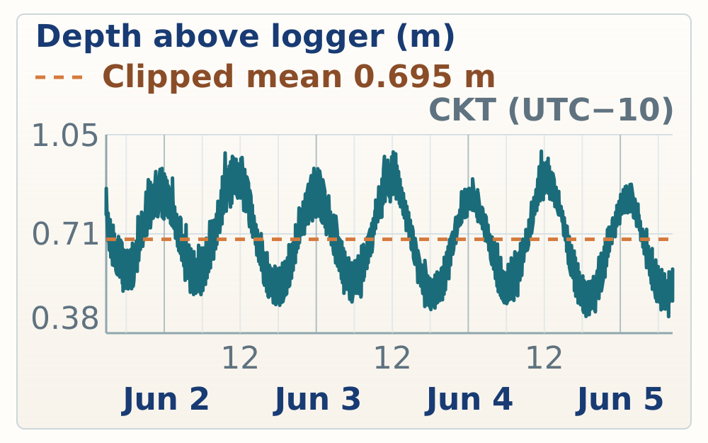
Site evidence
June 1 opened the Mangaia work with transfer logistics, the first harbor tide-gauge and reef-flat observations, and an afternoon traverse across the Saragossa HS109 fossil-reef outcrop. Field observations and Cook Atlas points distinguish the lower harbor flat from the higher coral-framework reef, then record HS109 samples, GCPs, recrystallized grainstone, and an inland coral head near the next cliff.
08:04-10:39
Overview
08:04 | MANGAIA-20260601-RN-027
Logistics note recording the airport locker code used during the Mangaia transfer.
The code is 2015.
Airport locker code
Logistics note recording the airport locker code used during the Mangaia transfer.
08:04 | MANGAIA-20260601-RN-028
Logistics note that rocks were stored in Locker 90 after payment and code assignment.
Rocks are stored in Locker 90. When you pay they give you a code and a locker.
Locker 90 rock storage
Logistics note that rocks were stored in Locker 90 after payment and code assignment.
08:05 | MANGAIA-20260601-RN-026
Logistics note that the vehicle charge was seven dollars per day.
They actually only charge us 7 per day.
Vehicle daily charge note
Logistics note that the vehicle charge was seven dollars per day.
10:33 | MANGAIA-20260601-RN-025
Transport note to return the truck to Pickering Motors Friday around 08:30 before airport transfer.
Drop truck off on Friday around 8.30 a.m. at Pickering Motors and then they will give us a ride over the airport.
Pickering truck drop-off
Transport note to return the truck to Pickering Motors Friday around 08:30 before airport transfer.
12:48-14:05
Overview
12:48 | MANGAIA-20260601-RN-024
Harbor stop noted perched beachrock just above the tidal flat and possible MIS 5e coral framework nearby, but the age relationship remains uncertain.
Perch beach rock just above the tidal flat and the harbor likely early Holocene. Closer to the harbor, it's across the large colonies of Branch and Coral. Suggesting that that's MIS 5e. The two are sort of sitting right on top of the trail here.
Harbor beachrock and reef-flat contact
Harbor stop noted perched beachrock just above the tidal flat and possible MIS 5e coral framework nearby, but the age relationship remains uncertain.
12:50 | MANGAIA-20260601-RN-023
Photo note records a coral pointing upward on the probable MIS 5e flat, flagged as possible growth position.
photograph of a coral at least pointing upwards maybe in situ on what's probably the 5E flat.
Possible in-situ coral on 5e flat
Photo note records a coral pointing upward on the probable MIS 5e flat, flagged as possible growth position.
12:59 | MANGAIA-20260601-RN-022
Alternative interpretation treats the lower flat and beachrock as a more conformable early Holocene to beach transition rather than a sharp older/younger break.
Second interpretation here that seems more likely is that the whole sequence is conformable. It's Holocene, early Holocene flat, then just kind of sideways transitions into a beach. Just a photograph, kind of a gal ashore with a little bit of sand left. You can see that sand trover hanging out into the spot. Just imagining that what you're standing on is the early Holocene movement. Let's see how this should look.
Harbor flat-to-beach transition
Alternative interpretation treats the lower flat and beachrock as a more conformable early Holocene to beach transition rather than a sharp older/younger break.
13:02 | MANGAIA-20260601-RN-021
Photo note records a nearly two-meter branching coral colony in the lower intertidal or fringing tidal flat.
The photograph of the nearly two-year diameter branch and coral colony in this lower early all-in-tidal flat or fringing tidal flat.
Lower tidal-flat branching coral
Photo note records a nearly two-meter branching coral colony in the lower intertidal or fringing tidal flat.
13:30 | MANGAIA-20260601-RN-020
Team chose the far side of Mangaia harbor for the tide gauge, planning to attach it to rock in a shallow-bank hole and measure it directly with GPS.
We decided to place the tide gauge in the harbor but on the far side where there's a shallow bank We'll walk and put it into one of the holes in the bank and attach it to a rock and then measure the tide gates directly with the GPS.
Harbor tide-gauge placement plan
Team chose the far side of Mangaia harbor for the tide gauge, planning to attach it to rock in a shallow-bank hole and measure it directly with GPS.
13:53 | MANGAIA-20260601-RN-019
Tide gauge was placed in the harbor water and photographed for later datum and deployment checks.
Tide gauge placed in the water, a couple photos of it.
Harbor tide gauge deployed
Tide gauge was placed in the harbor water and photographed for later datum and deployment checks.
15:07-16:23
Overview
15:07 | MANGAIA-20260601-RN-018
Access note says the rough road past the shipwreck is passable with the high-clearance truck.
The road is a little bit rough but we can get to the end after the shipwreck with this high clearance truck.
Saragossa road access
Access note says the rough road past the shipwreck is passable with the high-clearance truck.
15:14 | MANGAIA-20260601-RN-017
Road-end note identifies a backing/turnaround place for the truck near the Saragossa outcrop access.
Towards the end of the road there is a place to back the truck in so you can turn around.
Saragossa road turnaround
Road-end note identifies a backing/turnaround place for the truck near the Saragossa outcrop access.
15:21 | MANGAIA-20260601-RN-016
HS109 exposes dense coral framework roughly 10 m above sea level, with sea-oriented channels and branching coral ridges; compare with published Mangaia MIS 5e groove-and-spur reef context.
Finally at the end of the road looking at the outcrop. Maybe 10 meters above sea level above the bench. Just an incredibly dense reef network. Probably more coral diversity and density than anything we saw at H2. The outcrop is full of these channels that run to the sea. So you can see it's really nice and satellite imagery. And I just took a photograph of the coral that tends to colonize the inside of the channel. It lines itself up oriented direction towards the sea. So they sort of form these linear ridges towards the sea. They sit mostly in the lows in the edge or sides of the channels. And branching corals tend to populate most of the top of the little ridges.
HS109 channelized framework reef
HS109 exposes dense coral framework roughly 10 m above sea level, with sea-oriented channels and branching coral ridges; compare with published Mangaia MIS 5e groove-and-spur reef context.
15:24 | MANGAIA-20260601-RN-015
field audio establishes this Saragossa outcrop as site HS109.
This site will be HS109.
HS109 site assignment
field audio establishes this Saragossa outcrop as site HS109.
15:26 | MANGAIA-20260601-RN-014
Four photos document high coral diversity within about a one-meter radius at HS109.
Four photographs just show the quick survey of the diversity of the coral species in about a one-year radius.
HS109 coral diversity survey
Four photos document high coral diversity within about a one-meter radius at HS109.
15:28 | MANGAIA-20260601-RN-013
HS109 felt deeper-water than prior stops because coral-on-coral framework dominated and thick encrusters, worms, borings, and sand were not obvious.
Overall, this outcrop feels deeper than a lot of the environments we looked at on the end. And I say that because I'm not seeing thick sort of encrusters and worms and bores, the things that sort of colonize the coral. We're not happy. Something that we would see quite often in the back reach. There it really is, just coral on coral on coral on coral. No sand either. At least not clearly. Large amounts of sand.
HS109 deeper-looking coral framework
HS109 felt deeper-water than prior stops because coral-on-coral framework dominated and thick encrusters, worms, borings, and sand were not obvious.
15:41 | MANGAIA-20260601-RN-012
Photos document striking upward-branching coral colonies lining the front slope at HS109.
A couple of photographs of stunning upward branching coral colonies that line the front slope. This is where I need to slow the line.
HS109 branching-coral front slope
Photos document striking upward-branching coral colonies lining the front slope at HS109.
15:42 | MANGAIA-20260601-RN-011
Photo note uses a rainbow as a location marker near the HS109 survey.
A nice rainbow marks the equation.
HS109 rainbow location marker
Photo note uses a rainbow as a location marker near the HS109 survey.
16:31-17:34
Overview
16:46 | MANGAIA-20260601-RN-010
Photo note shows Billy and Roger on the next cliff above the coastal cliff, where cracks or faults may match linear features visible in drone imagery.
photograph of Billy and Roger standing on the next cliff above the coastal cliff and there's two faults or at least cracks through the rock sort of pointing up at them those cracks may be the large linear features you can see from up above in the drone.
Inland cliff cracks and lineaments
Photo note shows Billy and Roger on the next cliff above the coastal cliff, where cracks or faults may match linear features visible in drone imagery.
16:51 | MANGAIA-20260601-RN-009
Unit just above the road is described as heavily recrystallized grainstone, useful as a contrast with fresher coral framework nearby.
The unit just above the road is a heavily recrystallized grainstone.
Roadside recrystallized grainstone
Unit just above the road is described as heavily recrystallized grainstone, useful as a contrast with fresher coral framework nearby.
17:11 | MANGAIA-20260601-RN-008
HS109 sampling note records six coral samples plus a Tridacna sample labeled C.
HS109, six coral samples and a Tridacna which was labeled C.
HS109 samples and Tridacna
HS109 sampling note records six coral samples plus a Tridacna sample labeled C.
17:12 | MANGAIA-20260601-RN-007
Field mark: HS109 GCP3.
HS109 GCP3.
HS109 GCP3
Field mark: HS109 GCP3.
17:15 | MANGAIA-20260601-RN-006
Field mark: HS109 GCP7.
HS109 GCP7.
HS109 GCP7
Field mark: HS109 GCP7.
17:16 | MANGAIA-20260601-RN-005
Field mark: HS109 GCP5.
HS109 GCP5.
HS109 GCP5
Field mark: HS109 GCP5.
17:17 | MANGAIA-20260601-RN-004
Field mark: HS109 GCP1.
HS109 GCP1.
HS109 GCP1
Field mark: HS109 GCP1.
17:19 | MANGAIA-20260601-RN-003
Short field audio likely refers to HS109 GCP or sample pieces; verify against bag labels and GPS ledger.
Each has 109 keys in pieces.
HS109 GCP/sample pieces
Short field audio likely refers to HS109 GCP or sample pieces; verify against bag labels and GPS ledger.
17:28 | MANGAIA-20260601-RN-002
Team searched inland at the base of the next cliff in sharp makatea terrain for additional coral.
Photo caption, the team is searching for more coral inland at the base of the next cliff in a very sharp terrain.
HS109 inland coral search
Team searched inland at the base of the next cliff in sharp makatea terrain for additional coral.
17:34 | MANGAIA-20260601-RN-001
Field mark: HS109G sample at the coral head inland of the road.
HS109G sample.
HS109G sample
Field mark: HS109G sample at the coral head inland of the road.
| Site ID | Height (m above mean sea level) | Vertical position | Vertical accuracy | Vertical precision | Points | Notes |
|---|---|---|---|---|---|---|
| HS108 - Mangaia harbor base | 1.055 m | 13.527 m | 0.068 m | 0.006 m | 200 | Recorded by OMS |
| HS108 - Mangaia harbor, tide gauge | -0.667 m | 11.805 m | 0.068 m | 0.009 m | 200 | Collected by OMS, measured directly on tide gauge |
| HS108 - Mangaia harbor base 2 | 0.895 m | 13.367 m | 0.070 m | 0.004 m | 200 | No note recorded. |
| HS109 - saragasso - GCP3 | 12.723 m | 25.195 m | 0.093 m | 0.008 m | 200 | No note recorded. |
| HS109 - saragasso - gcp 4 | 11.818 m | 24.290 m | 0.083 m | 0.005 m | 200 | No note recorded. |
| HS109 - saragasso - gcp 1 | 12.639 m | 25.111 m | 0.077 m | 0.002 m | 100 | No note recorded. |
| HS109 - saragasso - gcp 5 | 12.770 m | 25.242 m | 0.067 m | 0.004 m | 100 | No note recorded. |
| HS109 - saragasso - gcp 7 | 11.065 m | 23.537 m | 0.064 m | 0.002 m | 100 | No note recorded. |
| HS109-C | 11.678 m | 24.150 m | 0.061 m | 0.002 m | 100 | Coral sample |
| HS109-B | 6.330 m | 18.802 m | 0.062 m | 0.002 m | 100 | Coral sample |
| HS109-A | 4.337 m | 16.809 m | 0.061 m | 0.002 m | 100 | Coral sample |
| HS109-D | 12.030 m | 24.502 m | 0.058 m | 0.003 m | 100 | Coral sample |
| HS109-E | 12.861 m | 25.333 m | 0.057 m | 0.005 m | 100 | Coral sample |
| HS109-Z | 12.857 m | 25.329 m | 0.057 m | 0.006 m | 100 | Shell sample for DK |
| HS109-F | 11.619 m | 24.091 m | 0.056 m | 0.006 m | 100 | Coral sample |
| Modern reef flat harbor | -0.095 m | 12.377 m | 0.069 m | No note recorded. | ||
| Modern Reef flat harbor | -0.128 m | 12.344 m | 0.068 m | 0.003 m | 100 | HS108 |
| Tide gauge Mangaia harbor | -0.663 m | 11.809 m | 0.068 m | 0.004 m | 100 | Measured directly on tide gauge |
| Cook Atlas GPS point 129 | -0.674 m | 11.797 m | 0.068 m | 0.006 m | 100 | No note recorded. |
| Harbor base station Mangaia | 0.885 m | 13.357 m | 0.072 m | 0.002 m | 100 | HS108 |
| HS109G Coral head at base of cliff, inland of road | 12.871 m | 25.343 m | 1.822 m | 0.035 m | 100 | Oana sampling a big head of astropora(?) medium honeycomb |
Tidal reference
Site evidence
June 2 concentrated on three Mangaia fossil-reef sites plus a harbor tide-gauge repeat. Araoa HS110 tested cave, notch, infill, and dated-coral hypotheses at the coast. HS111 Ivirua then documented a large growth-position framework reef and candidate older reef flat, and HS112 Karanga added a late afternoon comparison site with in-situ corals, modern low-tide reef-flat exposure, samples, and GCPs.
08:41-10:55
Overview
08:41 | MANGAIA-20260602-RN-054
Field mark: beach access at Araoa, the HS110 coastal cave and reef-framework site.
Beach access at Araoa.
Araoa beach access
Field mark: beach access at Araoa, the HS110 coastal cave and reef-framework site.
08:46 | MANGAIA-20260602-RN-053
Araoa access passes through a narrow slot in coastal MIS 5e framework; cave or erosional infill contains corals and sand that may be Holocene or younger 5e material.
The walk down to Araoa beach goes to a narrow slot in the coastal 5e outcrop. The outcrop itself is full of very large spectacular corals. It's a large coral framework reef so much what we've seen before. As you get closer to the water you start to see things within the sort of sea cave slash cave erosion of the cliffs that look like Holocene corals and sands. They come up to maybe a meter and a half or two meters including lots of varieties. Kind of seem like they're stuck on top of the sort of reddish cave cement flowstone.
Araoa slot and cave-infill reef
Araoa access passes through a narrow slot in coastal MIS 5e framework; cave or erosional infill contains corals and sand that may be Holocene or younger 5e material.
08:47 | MANGAIA-20260602-RN-052
Photo note records a drilled Porites in the notch/cave exposure at Araoa.
photograph of a drilled Porites in this sort of notch cave rising.
Drilled Porites in notch cave
Photo note records a drilled Porites in the notch/cave exposure at Araoa.
08:55 | MANGAIA-20260602-RN-051
Porites high in the cave, several meters above present ocean level, raises uncertainty over whether the feature is Holocene infill, 5e infill, or weathered older reef.
Porites really high up sort of in the cave proper probably four meters maybe three meters above the ocean today still kind of has this relationship that suggests it could be filling in the cave but I'm starting to doubt that it's Holocene maybe this is just a funny weathering feature to to to follow me problem.
High Porites cave uncertainty
Porites high in the cave, several meters above present ocean level, raises uncertainty over whether the feature is Holocene infill, 5e infill, or weathered older reef.
08:57 | MANGAIA-20260602-RN-050
Photos show coarse platy grainstone near eye level in the upper cave part of the Araoa outcrop.
Two photographs of a course sort of plating grainstone that's sort of at eye level near the top of the cave part of the Aroa outcrop.
Araoa platy grainstone
Photos show coarse platy grainstone near eye level in the upper cave part of the Araoa outcrop.
08:58 | MANGAIA-20260602-RN-049
Roger stands on loose sand/grainstone below a higher grainstone surface, prompting a question about how little elevation change would alter the interpretation.
Roger standing on sand and grainstone just not lithified yet and at his shoulder level behind him is the grainstone that I just photographed. So I do wonder how much would it take for that surface to just be a few meters higher.
Araoa sand and grainstone level
Roger stands on loose sand/grainstone below a higher grainstone surface, prompting a question about how little elevation change would alter the interpretation.
09:13 | MANGAIA-20260602-RN-048
Three hypotheses were recorded for Araoa: Holocene infill into a 5e cliff, 5e infill into an older cliff, or multiple events within MIS 5e; the drilled Gischler-age coral is central to testing them.
It really seems like the sequence of events here. The cliff must have formed, followed by a low-stand tree where you could make the cave, maybe it doesn't have to be that low. And then you've filled in the cave slash, a rosional feature with more corals in sand. The options are the cliff is 5E, the cave happens during the time between 5E and the Holocene, and all the infill is Holocene. The challenge with that is that the sand and corals go pretty high. The other option is that the cliff is actually an older interglacial and the infill would then be 5E. And a third option would be that all this could somehow happen within 5E. So you have a high stand, you form the reef, you drop the sea level, form the cave, you bring sea level back up within 5E, and flood the cave and grow some more corals. The drilled coral that I took a photograph of is likely Gischler's 125,000 year old coral at 2.5 meters. If that is true, then the infill is 5E, which sort of rules out the Holocene version of this story.
Araoa cave-infill hypotheses
Three hypotheses were recorded for Araoa: Holocene infill into a 5e cliff, 5e infill into an older cliff, or multiple events within MIS 5e; the drilled Gischler-age coral is central to testing them.
09:21 | MANGAIA-20260602-RN-047
Jacky suggested the drilled/dateable coral may have fallen from the cave wall and become cemented in place, allowing a young age within older-looking cave fill.
Jacky points out that a possible explanation is that the coral that was dated or drilled fell into the cave off of the wall and then got cemented in place which would allow the young age in what's actually a Holocene deposit.
Araoa fallen-coral alternative
Jacky suggested the drilled/dateable coral may have fallen from the cave wall and become cemented in place, allowing a young age within older-looking cave fill.
09:22 | MANGAIA-20260602-RN-046
A darker coral patch may be a small early Holocene reef sheltered behind a large boulder.
The darker patch of coral in the photograph may be the early Holocene, a tiny little reef that persisted behind its big boulder.
Araoa possible Holocene patch reef
A darker coral patch may be a small early Holocene reef sheltered behind a large boulder.
09:23 | MANGAIA-20260602-RN-045
Araoa unit includes abundant upward-branching corals plus flat-lying platy or encrusting corals.
This unit has abundant upward branch and corals and flat-lying sort of plating and cresting corals.
Araoa branching and platy corals
Araoa unit includes abundant upward-branching corals plus flat-lying platy or encrusting corals.
09:37 | MANGAIA-20260602-RN-044
Drone plan for HS110 prioritized a simple front-face pass over GCPs and a cautious cave pass with the pilot walking the drone.
The drone flying strategy at HS110 will be first to do a simple pass of the front face where most of the GCPs are. Then I'll try to do a more complicated pass in the cave where I'll walk with the drone to make sure that I don't hit anything.
HS110 drone plan
Drone plan for HS110 prioritized a simple front-face pass over GCPs and a cautious cave pass with the pilot walking the drone.
09:38 | MANGAIA-20260602-RN-043
HS110 sampling plan targeted the front face, possible Holocene patch, higher/back cave material, and the previously drilled coral for hypothesis testing.
The sampling strategy here is to collect a few pieces from the front, maybe even this really Holocene patch that I photographed earlier, and then work our way both up and back into this access point. We'll test some of the various hypotheses we've discussed so far. Wanna might also take a sample of the coral that's already been drilled so we can see if we get 125 for that sample.
HS110 sampling strategy
HS110 sampling plan targeted the front face, possible Holocene patch, higher/back cave material, and the previously drilled coral for hypothesis testing.
10:31 | MANGAIA-20260602-RN-042
Drone work at HS110 covered the outer wall and beach landing plus lower cave geometry, but the upper sample area remained poorly constrained.
Drone flight complete. Did a couple passes on the outer wall and the beach landing and then spent quite a bit of time trying to get at least the lower part of the cave but the upper part where I think the last sample comes from will it's just not constrainable with a drone. I used about one and two-thirds batteries.
HS110 drone flight complete
Drone work at HS110 covered the outer wall and beach landing plus lower cave geometry, but the upper sample area remained poorly constrained.
10:36 | MANGAIA-20260602-RN-041
Field mark: HS110 GCP3.
HS110GCP3.
HS110 GCP3
Field mark: HS110 GCP3.
10:36 | MANGAIA-20260602-RN-040
Field mark: HS110 GCP7.
HS110GCP7.
HS110 GCP7
Field mark: HS110 GCP7.
10:37 | MANGAIA-20260602-RN-039
The field note clarifies that HS110 is locally known as Araoa.
HS110 is locally known as ARA-OA. A-R-A-O-A.
Araoa local name note
The field note clarifies that HS110 is locally known as Araoa.
10:37 | MANGAIA-20260602-RN-038
Field mark: HS110 sample B.
HS110 sample B.
HS110 sample B
Field mark: HS110 sample B.
10:37 | MANGAIA-20260602-RN-037
Field mark: HS110 sample A.
HS110 sample A.
HS110 sample A
Field mark: HS110 sample A.
10:38 | MANGAIA-20260602-RN-036
Field mark: HS110 GCP5.
HS110GCP5.
HS110 GCP5
Field mark: HS110 GCP5.
10:38 | MANGAIA-20260602-RN-035
Field mark: HS110 GCP12.
HS110GCP12.
HS110 GCP12
Field mark: HS110 GCP12.
10:39 | MANGAIA-20260602-RN-034
HS110 sample C is the same coral previously drilled, making it important for comparing field context and age control.
HS110, not GCP, sample C. It's the same sample that was drilled previously.
HS110 sample C drilled coral
HS110 sample C is the same coral previously drilled, making it important for comparing field context and age control.
10:39 | MANGAIA-20260602-RN-033
Field mark: HS110 sample E.
HS110 sample E as an elephant.
HS110 sample E
Field mark: HS110 sample E.
10:39 | MANGAIA-20260602-RN-032
Field mark: HS110 GCP1.
HS-110 GCP-1.
HS110 GCP1
Field mark: HS110 GCP1.
10:41 | MANGAIA-20260602-RN-031
Two higher HS110 samples targeted a possible drilled Porites in growth direction and a large brain coral around the cave backside.
HS-110 two high samples, one through what looks like it may be a Porites that has a core that has been drilled sort of in the growth direction. That took a photo of that. And then a second sample that came from the very large brain coral sort of around the backside. So, that's it. I'm going to go back to the next slide. I'm going to go back to the next slide. I'm going to go back to the next slide. I'm going to go back to the next slide. I'm going to go back to the next slide. I'm going to go back to the next slide. I'm going to go back to the next slide. I'm going to go back to the next slide. I'm going to go back to the next slide. I'm going to go back to the next slide. I'm going to go back to the next slide. I'm going to go back to the next slide. I'm going to go back to the next slide. I'm going to go back to the next slide. I'm going to go back to the next slide. I'm going to go back to the next slide.
HS110 high Porites and brain-coral samples
Two higher HS110 samples targeted a possible drilled Porites in growth direction and a large brain coral around the cave backside.
10:44 | MANGAIA-20260602-RN-030
Photo note shows Jacky preparing to sample another brain coral between sample E and the previously mentioned higher samples.
Photograph of Jacky with the chisel about to take another sample of a brain coral that's somewhere between E and the two samples like previously mentioned that we're higher up.
HS110 Jacky brain-coral sample
Photo note shows Jacky preparing to sample another brain coral between sample E and the previously mentioned higher samples.
12:37-12:57
Overview
12:46 | MANGAIA-20260602-RN-029
Second tide-gauge measurement was made after lunch at the harbor.
Second type gauge measurement after lunch.
Harbor second tide-gauge measurement
Second tide-gauge measurement was made after lunch at the harbor.
12:47 | MANGAIA-20260602-RN-028
Billy collected GPS at the harbor while the crew finished lunch.
Billy Manson GPS while the crew finishes dinner at the harbor. Not dinner lunch at the harbor.
Harbor GPS during lunch
Billy collected GPS at the harbor while the crew finished lunch.
13:51-16:12
Overview
13:51 | MANGAIA-20260602-RN-027
HS111 Ivirua access follows a town road, steep makatea descent, ladder, and slot canyon to a flat with many small microatoll-like forms.
HS-111 Ivirua follow the road through town and then there's a small turn to the left. It's a little bit steep right when you turn down to come off the makatea and the road is pretty smooth again. Park at the end of the road there's a ladder and steep slot canyon through the high cliff down to a beautiful flat full of tons of small, what looked like micro atoll from above. I took a few photos of that and a few photos of the access point.
HS111 Ivirua access route
HS111 Ivirua access follows a town road, steep makatea descent, ladder, and slot canyon to a flat with many small microatoll-like forms.
13:52 | MANGAIA-20260602-RN-026
Duplicate first-impression note confirms HS111 is a framework reef with large growth-position corals.
First impressions of the outcrop is that it's. Um. Framework Reef. I walked over a bunch of in-situ growth position, large corals very reminiscent of one of the early stops on. Uh, at you.
HS111 duplicate framework note
Duplicate first-impression note confirms HS111 is a framework reef with large growth-position corals.
13:52 | MANGAIA-20260602-RN-025
First impression at HS111 was growth-position framework reef with large in-situ corals, reminiscent of early Atiu framework stops.
First impressions of the outcrop is that it's a framework reef. I walked over a bunch of in situ growth position large corals. Very reminiscent of one of the early stops on Etude.
HS111 framework first impression
First impression at HS111 was growth-position framework reef with large in-situ corals, reminiscent of early Atiu framework stops.
13:54 | MANGAIA-20260602-RN-024
Platy or crusting coral forms at HS111 appear aligned in a seaward orientation, a photo target for reef-fabric interpretation.
I note that the platy and crusting coral that we've seen a couple times now is also lined up in an orientation that points towards the sea just to photograph that.
HS111 platy corals point seaward
Platy or crusting coral forms at HS111 appear aligned in a seaward orientation, a photo target for reef-fabric interpretation.
13:57 | MANGAIA-20260602-RN-023
In-situ branching coral was photographed with a ruler at the top of the cliff.
In situ branching coral with a ruler at the top of the cliff.
HS111 branching coral with ruler
In-situ branching coral was photographed with a ruler at the top of the cliff.
14:13 | MANGAIA-20260602-RN-022
A second notch or crust horizon at HS111 may be early Holocene or another repeated elevation marker; it needs elevation and photo checks.
There's a second notch or ck horizon here. Perhaps early Holocene. We've seen similar features at similar elevations across a number of sites now both here and then at here.
HS111 second notch or crust horizon
A second notch or crust horizon at HS111 may be early Holocene or another repeated elevation marker; it needs elevation and photo checks.
15:09 | MANGAIA-20260602-RN-021
Field mark: HS111 GCP3.
HS111GCP3.
HS111 GCP3
Field mark: HS111 GCP3.
15:11 | MANGAIA-20260602-RN-020
Field mark: HS111 GCP1.
HS111GCP1.
HS111 GCP1
Field mark: HS111 GCP1.
15:16 | MANGAIA-20260602-RN-019
Field mark: HS111 GCP7.
HS 111 GCP7.
HS111 GCP7
Field mark: HS111 GCP7.
15:22 | MANGAIA-20260602-RN-018
Field mark: HS111 GCP5 and sample A.
HS111GCP5 and sample A.
HS111 GCP5 and sample A
Field mark: HS111 GCP5 and sample A.
15:24 | MANGAIA-20260602-RN-017
Field mark: HS111 GCP12, despite a site-number mismatch.
HS 1113 GCP12.
HS111 GCP12
Field mark: HS111 GCP12, despite a site-number mismatch.
15:27 | MANGAIA-20260602-RN-016
HS111 sample B is roughly 30 cm above sample A, with ruler-based uncertainty of about 10-15 cm.
HS111 sample B maybe 30 centimeters above sample A Sided by ruler but plus or minus 10 or 15 centimeters.
HS111 sample B above A
HS111 sample B is roughly 30 cm above sample A, with ruler-based uncertainty of about 10-15 cm.
15:45 | MANGAIA-20260602-RN-015
Some HS111 sample bags were mislabeled as 112, so sample IDs need checking against GPS and photos.
Some of the HS111 sample bags are labeled 112.
HS111 bag-label warning
Some HS111 sample bags were mislabeled as 112, so sample IDs need checking against GPS and photos.
15:47 | MANGAIA-20260602-RN-014
HS111 sample Z is a dense plate-shaped coral or encruster with corallites, selected as a possible well-preserved dating target.
HS-111 sample Z. It's one of these sort of flat, plate-shaped things that I've been calling in encrusters. Incredibly dense, really hard to break through, has beautiful corallites inside. It's not very sparkly in the sun, so I wonder if this is actually quite pristine. What drew me to the sample is that it reminds me a lot of palmata, a very dense coral that people live to date.
HS111 dense platy sample Z
HS111 sample Z is a dense plate-shaped coral or encruster with corallites, selected as a possible well-preserved dating target.
15:53 | MANGAIA-20260602-RN-013
Sample Z came from the right side above the staircase in the slot, facing the truck and away from the ocean.
HS111 sample Z comes from the right side above the staircase in the slot facing the truck. So the right side facing the truck away from the ocean.
HS111 sample Z location
Sample Z came from the right side above the staircase in the slot, facing the truck and away from the ocean.
15:58 | MANGAIA-20260602-RN-012
Field mark: HS111 sample C.
HS 111 sample C.
HS111 sample C
Field mark: HS111 sample C.
16:07 | MANGAIA-20260602-RN-011
The real HS111 sample C sits in a rubble field near a large coral and may not be in situ; this should be flagged before interpreting any date.
HS111 real sample C is sitting in a rubble field and there's a large coral but may not be in situ. Keep that in mind two years from now when you look at a date.
HS111 sample C rubble caution
The real HS111 sample C sits in a rubble field near a large coral and may not be in situ; this should be flagged before interpreting any date.
16:10 | MANGAIA-20260602-RN-010
At about 15 m elevation on the flat, HS111 preserves possible backreef encruster fabric that may relate to the Mangaia MIS 5e constructional reef surface.
Up behind the truck, a landward of the truck at HS 111. This is where I took that sample of the encruster. Oh, sorry. Out on the flat. It was in the notes. It's great. Out on the flat where we have GPS measurements of about 15 meters above sea level, the top surface has some evidence of essentially back reef encrusters. I just took a photograph of what I'm interpreting as that.
HS111 backreef encruster surface
At about 15 m elevation on the flat, HS111 preserves possible backreef encruster fabric that may relate to the Mangaia MIS 5e constructional reef surface.
16:12 | MANGAIA-20260602-RN-009
Large Tridacna sampled from the same surface supports the backreef or reef-flat interpretation.
That previous interpretation also lines up with the large Tridacna that we sampled from this surface.
HS111 Tridacna on flat
Large Tridacna sampled from the same surface supports the backreef or reef-flat interpretation.
16:38-17:32
Overview
16:38 | MANGAIA-20260602-RN-008
HS112 near Karanga exposes in-situ corals at similar elevation to HS111, with modern reef-flat microatolls beautifully exposed at low tide.
HS-112, Koringa. A bunch of in situ corals just photographed beautiful reframe work probably similar elevation to the last site. Park kind of near the airport and head down path and then through a tiny bit of jungle to get to the outcrop. We're here at Low Tide so the microatolls are beautifully exposed out in the reef flat.
HS112 Karanga framework reef
HS112 near Karanga exposes in-situ corals at similar elevation to HS111, with modern reef-flat microatolls beautifully exposed at low tide.
17:15 | MANGAIA-20260602-RN-007
Field mark: HS112 GCP4.
HS-112 GCP4.
HS112 GCP4
Field mark: HS112 GCP4.
17:17 | MANGAIA-20260602-RN-006
Field mark: HS112 GCP12.
HS-112GCP-12.
HS112 GCP12
Field mark: HS112 GCP12.
17:17 | MANGAIA-20260602-RN-005
Short non-field audio fragment during HS112 work; verify against surrounding GPS/photo sequence if needed.
Need to travel people on the pointy? I'm going out. Oh.
HS112 stray audio note
Short non-field audio fragment during HS112 work; verify against surrounding GPS/photo sequence if needed.
17:18 | MANGAIA-20260602-RN-004
Field mark: an HS112 GCP.
HS-112GCP.
HS112 GCP
Field mark: an HS112 GCP.
17:18 | MANGAIA-20260602-RN-003
Field mark: an HS112 GCP; transcript is ambiguous between GCP3 and GCP4.
HS-112GCP 3 or 4.
HS112 GCP3 or GCP4
Field mark: an HS112 GCP; transcript is ambiguous between GCP3 and GCP4.
17:20 | MANGAIA-20260602-RN-002
Field mark: HS112 GCP1.
HS-112GCP-1.
HS112 GCP1
Field mark: HS112 GCP1.
17:24 | MANGAIA-20260602-RN-001
Field mark: HS112 sample D.
It's just 112 sample D.
HS112 sample D
Field mark: HS112 sample D.
| Site ID | Height (m above mean sea level) | Vertical position | Vertical accuracy | Vertical precision | Points | Notes |
|---|---|---|---|---|---|---|
| HS110 shoreline, in surf | 0.116 m | 12.588 m | 0.134 m | 0.005 m | 100 | Araoa beach |
| HS110 water level | 0.009 m | 12.481 m | 0.095 m | 0.007 m | 100 | Second measurement |
| GPC3 | 0.533 m | 13.005 m | 1.125 m | 0.011 m | 100 | HS110 |
| GCP3 | 0.545 m | 13.017 m | 1.226 m | 0.007 m | 100 | HS110 retake to improve accuracy |
| GCP7 | 0.962 m | 13.434 m | 1.504 m | 0.005 m | 100 | HS110 |
| GCP7 | 0.950 m | 13.422 m | 1.584 m | 0.008 m | 100 | HS110 second point to increase accuracy |
| GCP5 | 0.785 m | 13.257 m | 1.927 m | 0.007 m | 100 | HS110, estimated at 40cm above waterline |
| GCP5 | 0.723 m | 13.195 m | 1.993 m | 0.003 m | 100 | HS110 second point for accuracy |
| HS110-B | -0.807 m | 11.665 m | 1.516 m | 0.202 m | 100 | No note recorded. |
| HS110-B | -0.638 m | 11.834 m | 0.953 m | 0.098 m | 100 | Second point for precision |
| GCP2 | 0.291 m | 12.763 m | 0.440 m | 0.026 m | 100 | HS110 |
| GCP12 float | 0.550 m | 13.022 m | 0.230 m | 0.042 m | 100 | No note recorded. |
| Hard ground just seaward of sandy beach | -0.059 m | 12.413 m | 0.135 m | 0.016 m | 100 | No note recorded. |
| GCP1 | 1.801 m | 14.273 m | 0.346 m | 0.014 m | 100 | HS110 |
| GCP1 | 1.791 m | 14.263 m | 0.604 m | 0.011 m | 100 | Second time, precision degrading |
| HS110C | 2.203 m | 14.675 m | 1.989 m | 0.043 m | 100 | Poor accuracy, sample collected on coral that had been cored. |
| Cook Atlas GPS point 149 | 0.976 m | 13.447 m | 0.070 m | 0.002 m | 100 | No note recorded. |
| Harbor base | 0.941 m | 13.413 m | 0.068 m | 0.003 m | 100 | No note recorded. |
| Tide gauge | -0.712 m | 11.759 m | 0.073 m | 0.004 m | 100 | Return to tide gauge at harbor |
| Tide gauge | -0.739 m | 11.733 m | 0.072 m | 0.003 m | 100 | No note recorded. |
| Cook Atlas GPS point 153 | 0.791 m | 13.263 m | 0.069 m | 0.004 m | 100 | No note recorded. |
| Inferred 5e reef flat | 14.823 m | 27.295 m | 0.450 m | 0.017 m | 100 | Across road from parking, flat area before you encounter the next set of corals that have heavy cementation and intense mastication leading to the next wall, this flat has corals and material that looks like algal micrite layers and small borers |
| Inferred 5e reef flat | 14.607 m | 27.079 m | 0.268 m | 0.024 m | 100 | Billy thinks this is a decent sea level indicator, that this would be cms to 1 m water depth |
| Inferred 5e reef flat | 14.518 m | 26.990 m | 0.199 m | 0.015 m | 100 | No note recorded. |
| HS111 coral sample from reef flat | 14.466 m | 26.937 m | 0.163 m | 0.007 m | 100 | This site is very close to Oana’s coral sample from up on the flat, same elevation and 4m away |
| Inferred 5e reef flat | 14.483 m | 26.955 m | 0.138 m | 0.011 m | 100 | No note recorded. |
| Cook Atlas GPS point 159 | 14.672 m | 27.144 m | 0.109 m | 0.007 m | 100 | No note recorded. |
| HS111C | 14.599 m | 27.071 m | 0.110 m | 0.007 m | 100 | Coral from reef flat |
| HS111C the real C | 14.634 m | 27.106 m | 0.106 m | 0.008 m | 100 | Note that this site has lots of rubble and even large samples might not be “bedrock” tho hard to imagine far from source |
| Bioencruster on inferred 5e reef flat | 14.792 m | 27.264 m | 0.102 m | 0.003 m | 100 | No note recorded. |
| HS112 | 9.569 m | 22.041 m | 0.380 m | 0.022 m | 100 | Karunga |
| GPC4 | 9.682 m | 22.154 m | 0.188 m | 0.006 m | 100 | HS112 |
| GPC4 | 9.721 m | 22.193 m | 0.142 m | 0.007 m | 100 | HS112 retake1 |
| GPC4 | 9.715 m | 22.187 m | 0.112 m | 0.005 m | 100 | HS112 retake2 |
| GPC5 | 9.925 m | 22.397 m | 0.094 m | 0.003 m | 100 | HS112 |
| GPC12 | 8.582 m | 21.054 m | 0.076 m | 0.003 m | 100 | HS112 |
| HS112-B | 10.674 m | 23.146 m | 0.070 m | 0.003 m | 100 | No note recorded. |
| GPC3 | 11.670 m | 24.142 m | 0.068 m | 0.003 m | 100 | HS112 |
| GPC cliff | 10.199 m | 22.671 m | 0.068 m | 0.003 m | 100 | HS112 |
| HS112-C | 10.302 m | 22.774 m | 0.069 m | 0.005 m | 100 | No note recorded. |
| HS112-D | 8.465 m | 20.936 m | 0.065 m | 0.006 m | 100 | No note recorded. |
| HS112-Z | 10.425 m | 22.897 m | 0.156 m | 0.008 m | 100 | No note recorded. |
| HS112-A | 9.069 m | 21.541 m | 1.351 m | 0.003 m | 100 | No note recorded. |
| HS111 gpc southeast cliff 1 | 11.422 m | 23.894 m | 0.143 m | 0.015 m | 200 | No note recorded. |
| HS111 gpc 5 southeast cliff pt 2 | 12.045 m | 24.517 m | 0.100 m | 0.004 m | 200 | No note recorded. |
| HS111 gpc 7 northwest cliff 1 | 11.947 m | 24.419 m | 0.266 m | 0.148 m | 200 | No note recorded. |
| HS111 gpc 7 northwest cliff 2 | 12.210 m | 24.682 m | 0.214 m | 0.189 m | 200 | No note recorded. |
| HS111 gpc 7 northwest cliff 3 | 12.296 m | 24.768 m | 0.163 m | 0.171 m | 200 | First two points had systematic drift so taking third pt |
| HS111 gpc 7 northwest cliff 4 | 12.185 m | 24.657 m | 0.132 m | 0.123 m | 200 | Still some drift from 2 to 3 so taking another |
| HS111 gpc big boulder | -1.698 m | 10.774 m | 2.812 m | 0.056 m | 200 | No note recorded. |
| HS111 gpc big boulder 2 | -0.769 m | 11.703 m | 2.734 m | 0.056 m | 200 | No note recorded. |
| HS111 gpc 1 beach 1 | -0.968 m | 11.504 m | 2.901 m | 0.075 m | 200 | No note recorded. |
| HS101 sample a | 11.859 m | 24.331 m | 0.221 m | 0.006 m | 200 | No note recorded. |
| HS111 sample b | 12.676 m | 25.148 m | 0.740 m | 0.017 m | 200 | No note recorded. |
Schedule lock
Rarotonga-side school commitment handled by the returning group.
Tidal reference
Site evidence
June 3 extended the Saragossa work upward and inland across Mangaia's makatea cliff sequence. The day documented a high makatea drive stop, a traverse on the second cliff above the earlier Saragossa outcrop, groove, notch, fracture, and cobble features with uncertain origin, and the HS113 intermediate patch-reef survey with samples and GCPs late in the day.
10:53
Overview
10:53 | MANGAIA-20260603-RN-026
Photo note from the drive down from Mangaia summit records a cliff in the high makatea.
Photo of a cliff in the Hayamakatea on the drive back down from the top of Mungai.
High makatea cliff photo
Photo note from the drive down from Mangaia summit records a cliff in the high makatea.
11:54-12:36
Overview
11:54 | MANGAIA-20260603-RN-025
Traverse above the first Saragossa site crossed spiky grainstone and sparse coral on the higher second cliff while searching for access and contacts.
Walking the spiky top of the second cliff out near Sarrokos Shipwreck. The place we worked the first day but just higher up. A lot of grainstone have not been able to find a goat trail yet. A few corals although they really take you looking hard but that could be weathering more than presents.
Saragossa second-cliff traverse
Traverse above the first Saragossa site crossed spiky grainstone and sparse coral on the higher second cliff while searching for access and contacts.
12:03 | MANGAIA-20260603-RN-024
Photo note records Tilly and Emily in the spiky makatea during the second-cliff traverse.
Tilly and Emily up in the spiky land.
Spiky makatea team photo
Photo note records Tilly and Emily in the spiky makatea during the second-cliff traverse.
12:15 | MANGAIA-20260603-RN-023
Photos from the second cliff show tilted-looking beds and a possible open notch behind a tree, flagged as a candidate paleo-notch.
photographs from the second cliff looking down at the slope and see linear maybe beds sort of tilting away and then an open notch behind a tree and I wonder if maybe that's a paleo notch.
Possible second-cliff paleo-notch
Photos from the second cliff show tilted-looking beds and a possible open notch behind a tree, flagged as a candidate paleo-notch.
12:23 | MANGAIA-20260603-RN-022
At the base of the high cliff, the team entered dense, obvious growth-position coral with diverse species, consistent with a major constructional reef zone.
Suddenly, right off of the high cliff, when you hit the base, you're in a ton of very obvious coral. Growth position, really dense, all kinds of different species, like suddenly in a very active leaf.
Dense coral at high-cliff base
At the base of the high cliff, the team entered dense, obvious growth-position coral with diverse species, consistent with a major constructional reef zone.
12:25 | MANGAIA-20260603-RN-021
Photos in a notch-like cave or groove show imbricated coarse sediment and dense coral pinnacles, with uncertainty between ancient 5e cobbles and modern cyclone reworking.
Three photographs from within essentially a notch or sort of almost looks like a paleo cave with a tidal notch in it. A few photographs of imbricated coarse sediments that kind of fill this groove. Curious if maybe these are ancient, so these are the cobbles forming during 5E up against this cliff or if it's modern soil, essentially cyclones are coming through and filling and eroding through this channel. The third photo shows this sort of light blue light gray pinnacles at the mouth of this groove and those are the dense corals that I previously photographed. A final photo after this note will be of the part of the groove that looks like it may be a paleo notch.
Paleo cave groove and cobbles
Photos in a notch-like cave or groove show imbricated coarse sediment and dense coral pinnacles, with uncertainty between ancient 5e cobbles and modern cyclone reworking.
12:28 | MANGAIA-20260603-RN-020
Photo note records encrusters growing vertically along the walls of a paleo-groove in the fossil reef.
photograph looking down a paleo groove in this coral reef where you can really nicely see the encrusters sort of growing vertically along the walls of this paleo groove.
Vertical encrusters in paleo-groove
Photo note records encrusters growing vertically along the walls of a paleo-groove in the fossil reef.
12:36 | MANGAIA-20260603-RN-019
Two pieces of Porites were collected from the photographed groove as a provisional June 3 sample.
collected of Porites from the groove that I previously photographed. For now we're calling it sample 6 3 sample 1 two pieces.
Porites groove sample
Two pieces of Porites were collected from the photographed groove as a provisional June 3 sample.
13:31-15:00
Overview
13:31 | MANGAIA-20260603-RN-018
Photos show Porites encrusting along a groove and forming a mound edge, with rounded coral-shell cobbles in the groove.
Two photographs of Porites. One is encrusting and growing along a groove. The other sort of makes up the mound on the edge of the groove. In the groove itself, there's more of these sort of rounded cobbles like the clasts that I saw sort of up the larger cave or groove earlier today.
Porites groove and mound photos
Photos show Porites encrusting along a groove and forming a mound edge, with rounded coral-shell cobbles in the groove.
13:36 | MANGAIA-20260603-RN-017
Photos from a reef hole show cemented rounded cobbles of coral, shells, and carbonate pieces with encrusting and branching corals on the walls.
Three photographs from probably standing in a hole on a reef. We have the gravel serve at our feet. Large rounded cobbles made of corals and shells and other carbonate pieces cemented together. At eye level and higher along the walls there are encrusting varieties and branching corals. Maybe even some burrows it's hard to tell if it's coral or burrows from here. Take another photo in a minute.
Cemented coral-shell cobbles
Photos from a reef hole show cemented rounded cobbles of coral, shells, and carbonate pieces with encrusting and branching corals on the walls.
13:43 | MANGAIA-20260603-RN-016
A notch-shaped feature may be a collapsing cave, flushed ancient channel, or younger overhang; coral in and above the walls makes age relationships uncertain.
photograph of a notch shaped feature but so I see more and more of this and think about the elevation context it really seems like these might be caves that are collapsing today and flushing out or some kind of ancient channel that has this overhang for some reason this flowstone along it and there's not much flow in other places and as coral in the walls and above it so if it is a cave it's got to be younger than the corals I guess.
Notch-shaped cave/channel uncertainty
A notch-shaped feature may be a collapsing cave, flushed ancient channel, or younger overhang; coral in and above the walls makes age relationships uncertain.
13:56 | MANGAIA-20260603-RN-015
The relation between the road plane, reef at the cliff base, and second cliff remains unclear; the exposure may be deeper reef of the same highstand rather than a separate terrace contact.
It's really challenging to work out the relationship between the plane that the road is along and the second cliff. We've been walking along the front. We find what looks like pretty intact, deep reef right at the front of the cliff. As we approach the cliffs, there's no obvious, notching or contacts, even like, constructional terraces, caves, beach sediment. It just kind of looks like a slumped pile. It just took a few photos of the general landscape. Still gonna walk a bit and look for more. But I'm starting to wonder if it's possible that the reef we're actually walking in here at the base is just a deeper part of the sea level that's associated with the second cliff. And the cliff itself is the front slope of that engine environment. Sandy or not, there's no less big holes in there. And it's sitting on top of FID. There's not obvious that the corals themselves, the samples are super old and weathered. And it kind of seemed like the FID samples closer to the cliff one.
Second-cliff contact uncertainty
The relation between the road plane, reef at the cliff base, and second cliff remains unclear; the exposure may be deeper reef of the same highstand rather than a separate terrace contact.
14:01 | MANGAIA-20260603-RN-014
Photo note marks a distant notch-like feature for closer inspection.
Just took a photograph of what in the distance looks like it might be a notch. We'll try to get closer and check it out.
Distant notch target
Photo note marks a distant notch-like feature for closer inspection.
14:33 | MANGAIA-20260603-RN-013
Closer inspection suggests the candidate notch may instead be a fracture, fault exposure, or coral-bearing bedrock of the higher cliff.
Because this feature doesn't appear to be a notch, it might be just how one of these fractures are faults outcrops along the cliff. Or just chance. There's no obvious notch organisms growing along the wall. The first piece I broke off was a coral. I can see more coral here. I think it's just the bedrock of the higher cliff.
Fracture rather than notch
Closer inspection suggests the candidate notch may instead be a fracture, fault exposure, or coral-bearing bedrock of the higher cliff.
14:34 | MANGAIA-20260603-RN-012
Photos show a narrow, patchy second bench with coral reef, dolines, and framework, possibly an intermediate reef or low coral garden on a higher stand.
Two photos showing the perspective from this point where the pseudo notch was. There's definitely a second bench, it's not very wide. It's what we've been walking through and it's been sort of patchy along the second cliff face. It's high, it's a coral reef with dolleys and tons of framework. It's really suggestive of something in between seven and eleven. Maybe it's just a low coral garden during stage eleven. This bay is a U.N. flat.
Patchy second bench reef
Photos show a narrow, patchy second bench with coral reef, dolines, and framework, possibly an intermediate reef or low coral garden on a higher stand.
14:39 | MANGAIA-20260603-RN-011
Photos frame lower coral reef, vertical walls, a recrystallized backreef/microbial flat with sparse corals, and the higher second cliff.
Some photographs showing really the three layers here. There's a coral reef at the bottom. Some vertical walls and a higher unit that seems mostly heavily recrystallized. Back reef microbial flat has a few coral pieces here and there but it's certainly not 100% coral like what I'm standing in. And then in the far distance is the top of this probably stage 11 the second high cliff.
Three-layer reef exposure
Photos frame lower coral reef, vertical walls, a recrystallized backreef/microbial flat with sparse corals, and the higher second cliff.
14:43 | MANGAIA-20260603-RN-010
Large Tridacna was photographed on the flat at the top of the first cliff.
large Tridacna in the flat at the top of cliff one.
Tridacna on cliff-one flat
Large Tridacna was photographed on the flat at the top of the first cliff.
14:46 | MANGAIA-20260603-RN-009
Toward the coast, the first cliff becomes more coral-rich and develops rivulets or gullies running seaward.
The first cliff comes to the coastline. It becomes richer and richer in coral density and starts to develop these Rivulets or little gullies running out to the sea.
First cliff gullied reef fabric
Toward the coast, the first cliff becomes more coral-rich and develops rivulets or gullies running seaward.
15:00 | MANGAIA-20260603-RN-008
Photo records the probable MIS 5e reef flat, second high cliff, and an intermediate reef feature targeted for origin testing.
photograph of me standing on probably the 5e reef flat the second high cliff is in the distance and in the middle ground there's sort of a up to eye level maybe a little taller than me intermediate reef that's one we're going to survey and try and figure out its origin.
Possible 5e flat and intermediate reef
Photo records the probable MIS 5e reef flat, second high cliff, and an intermediate reef feature targeted for origin testing.
15:59-17:56
Overview
15:59 | MANGAIA-20260603-RN-007
Photo note records coral composing most spines or spurs along the first cliff.
Just photographed the coral that makes up most of the spines of the spurs here along the cliff, the first type cliff.
Coral spurs on first cliff
Photo note records coral composing most spines or spurs along the first cliff.
17:06 | MANGAIA-20260603-RN-006
GPS work in lows between diamond-shaped intermediate highs showed abundant lower coral and more weathered coral on higher features.
The photograph of Roger taking a GPS point in the low that sort of sits between these diamond-shaped intermediate highs. There's a lot of coral low down where Roger is. Emilia and I are going to poke around further to see if that trend continues. There's some coral higher up. Maybe it's along the walls. Maybe it's on top. It's a little hard to tell. The high features are a bit more beat up than what's in the lower parts.
HS113 lows between intermediate highs
GPS work in lows between diamond-shaped intermediate highs showed abundant lower coral and more weathered coral on higher features.
17:10 | MANGAIA-20260603-RN-005
Repeated checks suggest the intermediate highs may be patch reefs with channels between them, perhaps exposed briefly or grown up to a sea-level limit.
The more we look at these higher features in the sort of mid-sea level stand, as I've been calling it, the more coral we see. Seems very likely that these are actually patch reefs themselves and the channels are just channels running between the reef. Maybe because we see less big corals at the top, these were either exposed briefly as sea level is falling or they grew up to sea level. It would be nice to see some kind of micro at all right at the top, but I think it's just too weathered for that to be realistic.
Intermediate patch-reef interpretation
Repeated checks suggest the intermediate highs may be patch reefs with channels between them, perhaps exposed briefly or grown up to a sea-level limit.
17:19 | MANGAIA-20260603-RN-004
Emily noted that the high patches are dominated by delicate upward-branching Acropora-like coral until the team enters the lows.
Emily pointed out that nearly 90% of the coral on these high patches is the upward branching delicate, probably Acropora. It's really remarkable that it's almost the only species we see out here until you get into the lows. What was that?
Acropora-dominated high patches
Emily noted that the high patches are dominated by delicate upward-branching Acropora-like coral until the team enters the lows.
17:26 | MANGAIA-20260603-RN-003
HS113 sample I is a growth-position coral near a low rear GCP; preservation looks good internally despite poor outer surface.
Two photos of HS113 sample eye. Growth position coral near one of the GCPs. The one that was low in the back towards the second high cliff. Preservation seems pretty good. The outer surface is not great, but no infill, not sparkly at all.
HS113 sample I growth-position coral
HS113 sample I is a growth-position coral near a low rear GCP; preservation looks good internally despite poor outer surface.
17:31 | MANGAIA-20260603-RN-002
Field mark: HS113 sample I.
HS113 sample I.
HS113 sample I
Field mark: HS113 sample I.
17:55 | MANGAIA-20260603-RN-001
End-of-day note warns that some HS113 observations lack GPS points because the team ran out of time.
On this site, we just want the TV brand out of time on the day. So we didn't GPS also, GPS is a don't be alarm if you don't find some GPS points.
HS113 missing-GPS caution
End-of-day note warns that some HS113 observations lack GPS points because the team ran out of time.
| Site ID | Height (m above mean sea level) | Vertical position | Vertical accuracy | Vertical precision | Points | Notes |
|---|---|---|---|---|---|---|
| HS113 Saragossa gcp 3 | 11.751 m | 24.223 m | 0.113 m | 0.015 m | 200 | No note recorded. |
| HS113 saragossa sample a | 11.579 m | 24.051 m | 0.097 m | 0.009 m | 200 | No note recorded. |
| HS113 saragossa sample b | 10.467 m | 22.938 m | 0.077 m | 0.005 m | 200 | No note recorded. |
| HS113 Saragossa gcp 12 | 6.614 m | 19.086 m | 0.069 m | 0.031 m | 200 | No note recorded. |
| HS113 saragossa sample c | 14.429 m | 26.901 m | 0.061 m | 0.002 m | 200 | No note recorded. |
| HS113 saragossa sample d | 14.035 m | 26.507 m | 0.058 m | 0.002 m | 200 | No note recorded. |
| JS113 saragossa sample f | 14.903 m | 27.375 m | 0.079 m | 0.023 m | 200 | No note recorded. |
| HS113 saragossa sample e | 14.957 m | 27.429 m | 0.343 m | 0.012 m | 200 | No note recorded. |
| HS113 saragossa gcp 4 low precision pt | 14.010 m | 26.482 m | 1.060 m | 0.160 m | 200 | No note recorded. |
| HS113 saragossa gcp 4 higher precision pt | 14.403 m | 26.875 m | 0.212 m | 0.022 m | 200 | No note recorded. |
| HISEAS saragossa gpc 5 | 17.189 m | 29.661 m | 0.124 m | 0.017 m | 200 | No note recorded. |
| HS113 saragossa sample g | 15.255 m | 27.727 m | 0.090 m | 0.012 m | 200 | No note recorded. |
| HS113 saragossa sample h | 13.468 m | 25.940 m | 1.371 m | 0.034 m | 200 | No note recorded. |
| HS113 saragossa sample i | 15.305 m | 27.777 m | 0.309 m | 0.032 m | 200 | No note recorded. |
| HS113 saragossa sample j | 15.134 m | 27.606 m | 0.164 m | 0.050 m | 200 | No note recorded. |
| HS113 saragossa gpc 1 | 14.874 m | 27.346 m | 0.422 m | 0.015 m | 200 | No note recorded. |
Schedule lock
Coordinate with Principal Michael Papatua; keep the field plan clear enough for the school visit.
Rarotonga-side youth and environment NGO commitment handled by the returning group.
Tidal reference
Site evidence
June 4 paired a morning modern tidal-flat survey at HS114 Araoa Beach 2 with afternoon HS115 work across a shoreward transect, samples, GCPs, and a higher reef near the second high cliff. The morning work emphasized water-depth and datum control, followed by increasingly complex afternoon questions about in-situ framework, vegetation-weathering effects, fallen cliff blocks, sea-cave collapse, and possible higher-reef attachment.
08:54-10:28
Overview
No rock-focused overview recorded for this site yet.
08:54 | MANGAIA-20260604-RN-022
Before the school visit, the team planned a drone survey of the modern tidal flat while GPS/ruler measurements recorded tidal-flat elevation and water depth.
Before school this morning we're going to do a quick survey with the drone of the modern tidal flat. The GPS and ruler team is going to walk through the water measuring the tidal flat elevation and noting the water depth on the GPS comment. I will fly the drone just in sort of a pan view over the tidal flat pretty high resolution.
Modern tidal-flat drone survey
Before the school visit, the team planned a drone survey of the modern tidal flat while GPS/ruler measurements recorded tidal-flat elevation and water depth.
09:53 | MANGAIA-20260604-RN-021
field audio assigns the modern reef/water-depth survey as HS114 at Araoa Beach 2.
Reef survey will be HS114. Araoa Beach 2.
HS114 Araoa Beach 2
field audio assigns the modern reef/water-depth survey as HS114 at Araoa Beach 2.
14:22-15:37
Overview
14:22 | MANGAIA-20260604-RN-020
Transect began at the reef edge with preserved framework, Porites-like groups, and encrusters before walking landward toward the second high cliff.
A bunch of photographs of the reef right up against the sea. We'll now walk on transect back towards the second high cliff. This reef looks a lot like what we've seen. All framework. Pedial groups preserved with encrusters inside and in the bottom of them. Yep, pretty standard.
HS115 shoreward framework transect
Transect began at the reef edge with preserved framework, Porites-like groups, and encrusters before walking landward toward the second high cliff.
14:24 | MANGAIA-20260604-RN-019
Weathering changes into the trees may reflect vegetation effects, landward reef position, early cementation, or bioencruster abundance.
The weathering chain is a little bit as we get into the trees. It's unclear if that's just because there are trees here or if we're moving further back on the reef to a place where there's more maybe early cementation or bio encrusters.
HS115 weathering transition into trees
Weathering changes into the trees may reflect vegetation effects, landward reef position, early cementation, or bioencruster abundance.
14:25 | MANGAIA-20260604-RN-018
Cleared flat contains pits, sand, moved boulders, and still-obvious in-situ large corals, making it a likely tidal-flat surface associated with the first high cliff/MIS 5e reef.
Out on the flat now it's clearly been at least partially cleared. There are pits where maybe a backhoe has dug, a lot of sand, some large boulders that have been moved, but underfoot it's clear there's still large corals in situ. A few photographs sort of verifying that. So very likely this is the tidal flat surface associated with the first height cliff in mass 5e.
HS115 cleared flat with in-situ corals
Cleared flat contains pits, sand, moved boulders, and still-obvious in-situ large corals, making it a likely tidal-flat surface associated with the first high cliff/MIS 5e reef.
14:35 | MANGAIA-20260604-RN-017
Perched boulder on the first high cliff may be an older analogue for boulders falling into lower tidal flats as cliffs retreat.
A perched boulder on the first high cliff right on top of the healthy coral reef may be a 5e analog of the photograph I took a few minutes ago of the 5e boulders falling into the Holocene tidal flat. Maybe this is the stage 9 or 11 cliff, the last rim then of it as it erodes back.
HS115 perched boulder on high cliff
Perched boulder on the first high cliff may be an older analogue for boulders falling into lower tidal flats as cliffs retreat.
14:39 | MANGAIA-20260604-RN-016
Meter-scale red, mottled, holey carbonate outcrops under trees contain coral bits and recrystallized texture; vegetation versus primary fabric remains unresolved.
At the top of the flat, when you get back into the trees, there are little sort of meter scale outcroppings of carbonate. It's very pink red, modeled, full of holes and bugs. Again, hard to tell how much of this is. The pendant is trees versus primary. The rocks themselves, they have bits of coral, they have a lot of texture, suggestive of recrystallization, maybe back reefing encrusters, but maybe it's happening because of the plants and the roots. We'll continue on to the next outcrop on the other side of the trees next.
HS115 red mottled carbonate
Meter-scale red, mottled, holey carbonate outcrops under trees contain coral bits and recrystallized texture; vegetation versus primary fabric remains unresolved.
14:42 | MANGAIA-20260604-RN-015
Photos show gentle slope, tree-separated mounds, and cliff-line topography that require mapping before assigning terrace level.
Two photographs showing sort of the lay of the land there are gentle slope up to the cliff with some mounds in the front that said a little bit higher trees separate them and maybe a slightly higher feature along the wall and the cliff itself I'm not sure is the highest cliff I have to keep going I think there's a close nearby one that's even higher.
HS115 slope and mounds toward cliff
Photos show gentle slope, tree-separated mounds, and cliff-line topography that require mapping before assigning terrace level.
14:50 | MANGAIA-20260604-RN-014
Fresh mound surface lacks obvious coral and may be heavily recrystallized grainstone.
photograph of a fresh surface on the mound. No obvious corals up here heavily recrystallized maybe originally a grainstone.
HS115 recrystallized mound surface
Fresh mound surface lacks obvious coral and may be heavily recrystallized grainstone.
14:52 | MANGAIA-20260604-RN-013
Backside of the mound suggests it may be a fallen, flipped piece of cliff rather than in-place reef surface.
The photograph of the backside of the mound that I was just standing on makes me suspect this is actually a piece of the cliff that it's fallen and flipped over.
HS115 possible fallen cliff block
Backside of the mound suggests it may be a fallen, flipped piece of cliff rather than in-place reef surface.
14:54 | MANGAIA-20260604-RN-012
A blue-black color change on the cliff front may explain the apparent break seen from a distance, with smoother weathering below more karstified upper rock.
There's a distinct sort of blue to black color change here right on the front of the cliff. This is the feature that far away I sort of suggested that maybe there was a third thing along the cliff that looked like a break. I think what I was seeing was the color change. This is where there's a little bit more smoothly than the upper rocks which are more carstered.
HS115 cliff color-change contact
A blue-black color change on the cliff front may explain the apparent break seen from a distance, with smoother weathering below more karstified upper rock.
15:01 | MANGAIA-20260604-RN-011
Speculative model: a stage 9 sea cave or cliff was notched, corals grew in front, and roof or wall blocks later collapsed into the slope.
Speculating that the fallen blocks have actually been part of the top of a sea cave or the cliff during stage 9. Sea level came up, notched into the wall here. Corals grew in front of it and then eventually these pieces just fell down. The slope has kind of also relaxed a bit and all the corals are sort of down in this field without very many trees.
HS115 sea-cave collapse hypothesis
Speculative model: a stage 9 sea cave or cliff was notched, corals grew in front, and roof or wall blocks later collapsed into the slope.
15:18 | MANGAIA-20260604-RN-010
Photos contrast the possible stage 9 carbonate front with the adjacent flat, clarifying the site topography.
Two photographs, the first one showing the front of the carbonate that makes up this potentially stage 9 unit and the second photograph just rotated to the left to show the flat. It really shows the distinction in topography here.
HS115 reef-flat topographic contrast
Photos contrast the possible stage 9 carbonate front with the adjacent flat, clarifying the site topography.
15:19 | MANGAIA-20260604-RN-009
field audio assigns the afternoon outcrop as HS115.
This site would be HS115.
HS115 site assignment
field audio assigns the afternoon outcrop as HS115.
15:47-17:02
Overview
16:25 | MANGAIA-20260604-RN-008
Field mark: HS115 sample BD1.
HS115 sample BD1.
HS115 sample BD1
Field mark: HS115 sample BD1.
16:26 | MANGAIA-20260604-RN-007
Previous sample came about 10-15 m from the cliff wall on the MIS 5e reef surface.
Previous sample comes from maybe 10 to 15 meters from the cliff wall, the 5B reef.
HS115 BD1 source distance
Previous sample came about 10-15 m from the cliff wall on the MIS 5e reef surface.
16:29 | MANGAIA-20260604-RN-006
Photos document an uncommon platy coral form at HS115.
Photographs of a platy coral don't see that form very often.
HS115 platy coral photo
Photos document an uncommon platy coral form at HS115.
17:02 | MANGAIA-20260604-RN-005
Field audio lists five HS115 samples A-E plus BD1.
HS115 5 samples, ABCDE plus BD1.
HS115 samples ABCDE plus BD1
Field audio lists five HS115 samples A-E plus BD1.
17:15-17:26
Overview
17:15 | MANGAIA-20260604-RN-004
Transect from car to second high cliff found a higher reef with large in-situ corals under Casuarina-like trees, possibly a stage 9 unit abutting the stage 11 cliff.
Just take a bunch of photographs on a transect from the car up to the stage 11 cliff or the second high cliff. We stopped the car because there were a bunch of looks like almost like Casuarina but like a pine-like tree. It looked like a grove that was really tall. We were curious if that was topography or just trees and we walked in and found that it actually was a very high reef. Large in situ corals, of course the weathering kind of sucks underneath the trees but feels quite a bit higher than what we just surveyed. Likely the stage 9 reef, the photos at the end show the backside where we kind of step out onto the second cliff and the corals suddenly stop right at the base of this cliff.
Higher reef near stage 11 cliff
Transect from car to second high cliff found a higher reef with large in-situ corals under Casuarina-like trees, possibly a stage 9 unit abutting the stage 11 cliff.
17:17 | MANGAIA-20260604-RN-003
Corals may be attached to the higher cliff; ages would be needed to test whether this also applies to the feature being called stage 9.
It is possible that the corals are actually attached to this higher cliff. If that's true, then it might be true of the thing that we've been calling 9 along. Ages would be the only way to tell. Probably not going to date this part.
Higher-cliff coral attachment caution
Corals may be attached to the higher cliff; ages would be needed to test whether this also applies to the feature being called stage 9.
17:21 | MANGAIA-20260604-RN-002
Highest rocks step down into smoother blue carbonate with corals, possibly the same coral-bearing unit seen earlier but better developed here.
The transition here off of the highest rocks, we also sort of step down into a bluer looking carbonate that weathers a little bit more smoothly, less micro carsting, and has the corals in it. So I'm speculating that it's the same unit that we were looking at before, just the reef over here was a bit more established.
Blue carbonate coral-bearing transition
Highest rocks step down into smoother blue carbonate with corals, possibly the same coral-bearing unit seen earlier but better developed here.
17:26 | MANGAIA-20260604-RN-001
Photos from the car show the possible stage 9 mound covered by pine-like trees.
Two photographs showing the view of the mound, the stage nine mound from the car covered in the pine trees.
Stage 9 mound roadside view
Photos from the car show the possible stage 9 mound covered by pine-like trees.
| Site ID | Height (m above mean sea level) | Vertical position | Vertical accuracy | Vertical precision | Points | Notes |
|---|---|---|---|---|---|---|
| HS114 avarua water depth gcp 5 first pt | 0.255 m | 12.727 m | 0.222 m | 0.029 m | 200 | No note recorded. |
| HS114 avarua water depth pt 1 69-74 cm | -0.852 m | 11.620 m | 0.132 m | 0.069 m | 200 | No note recorded. |
| HS114 avarua water depth pt 2 24-31 cm | -0.422 m | 12.050 m | 0.107 m | 0.012 m | 100 | No note recorded. |
| HS114 avarua water depth pt 3 50-53 cm | -0.722 m | 11.750 m | 0.098 m | 0.017 m | 100 | No note recorded. |
| HS114 avarua water depth pt 4 17-24 cm | -0.422 m | 12.050 m | 0.091 m | 0.114 m | 100 | No note recorded. |
| HS114 avarua water depth pt 5 66-72 cm | -0.843 m | 11.629 m | 0.082 m | 0.005 m | 100 | No note recorded. |
| HS114 avarua water depth pt 6 44-47 cm | -0.628 m | 11.844 m | 0.075 m | 0.013 m | 100 | No note recorded. |
| HS114 avarua water depth pt 6 33-37 cm | -0.506 m | 11.966 m | 0.070 m | 0.013 m | 100 | No note recorded. |
| HS114 avarua water depth pt 7 22-25 cm | -0.383 m | 12.089 m | 0.067 m | 0.028 m | 100 | No note recorded. |
| HS114 avarua water depth pt 8 60-65 cm | -0.775 m | 11.697 m | 0.064 m | 0.047 m | 100 | No note recorded. |
| HS114 avarua water depth pt 9 11-13 cm | -0.240 m | 12.232 m | 0.063 m | 0.020 m | 100 | No note recorded. |
| HS114 avarua water depth pt 10 20-26 cm | -0.360 m | 12.112 m | 0.062 m | 0.010 m | 100 | No note recorded. |
| HS114 avarua water depth pt 11 46-51 cm | -0.546 m | 11.926 m | 0.060 m | 0.006 m | 100 | No note recorded. |
| HS114 avarua water depth pt 12 67-72 cm | -0.702 m | 11.770 m | 0.062 m | 0.005 m | 100 | No note recorded. |
| HS114 avarua water depth pt 13 32-35 cm | -0.353 m | 12.119 m | 0.059 m | 0.009 m | 100 | No note recorded. |
| HS114 avarua water depth pt 14 22-26 cm | -0.312 m | 12.160 m | 0.059 m | 0.020 m | 100 | No note recorded. |
| HS114 avarua water depth gcp 5 second point | 0.483 m | 12.955 m | 0.058 m | 0.012 m | 100 | No note recorded. |
| HS114 avarua water depth gcp 8 | -0.436 m | 12.036 m | 0.277 m | 0.012 m | 100 | No note recorded. |
| HS114 avarua water depth gcp 7 | -0.227 m | 12.245 m | 0.356 m | 0.025 m | 100 | No note recorded. |
| HS114 avarua water depth gcp 3 | 0.533 m | 13.005 m | 0.103 m | 0.030 m | 100 | No note recorded. |
| HS114 avarua water depth gcp 12 | 0.544 m | 13.016 m | 0.085 m | 0.006 m | 100 | No note recorded. |
| HS115 soccer field 3 gcp 12 | 12.137 m | 24.609 m | 0.063 m | 0.004 m | 500 | No note recorded. |
| HS115 gpc 1 | 12.069 m | 24.541 m | 0.067 m | 0.003 m | 100 | No note recorded. |
| HS115 gpc 3 | 12.517 m | 24.989 m | 0.067 m | 0.003 m | 200 | No note recorded. |
| HS115 sample a | 12.087 m | 24.559 m | 0.064 m | 0.003 m | 200 | No note recorded. |
| HS115 gpc 4 | 11.466 m | 23.938 m | 0.065 m | 0.006 m | 200 | No note recorded. |
| HS115 gcp 8 | 17.105 m | 29.577 m | 0.135 m | 0.006 m | 200 | No note recorded. |
| HS115 sample d | 17.296 m | 29.768 m | 0.114 m | 0.055 m | 200 | No note recorded. |
| HS115 sample e | 17.952 m | 30.424 m | 0.227 m | 0.033 m | 200 | No note recorded. |
| HS115 gpc 7 | 16.952 m | 29.424 m | 0.082 m | 0.031 m | 100 | No note recorded. |
| HS115 sample c | 17.164 m | 29.636 m | 0.078 m | 0.038 m | 100 | No note recorded. |
| HS115 sample b | 13.923 m | 26.395 m | 0.118 m | 0.002 m | 100 | No note recorded. |
Flight timing
Tidal reference
Flight timing
Tidal reference
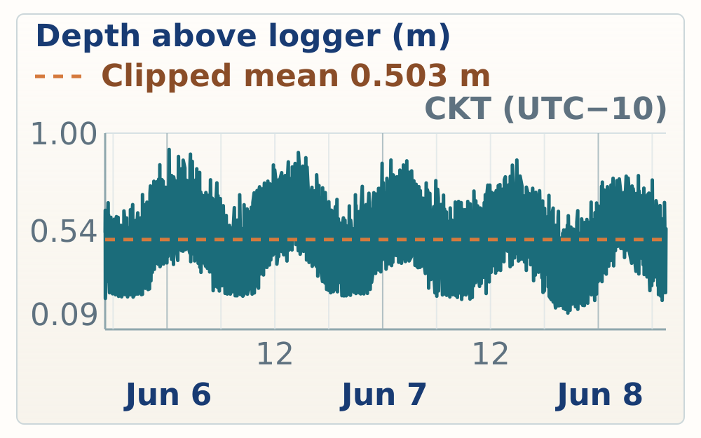
Site evidence
June 5 opened the Mauke block with harbor tide-gauge setup and an evening beach-outcrop check farther south on the coast. Field observations tied the harbor gauge to concrete/seawall measurements and documented a beach exposure with repetitive, large spur-and-groove relief, encrusters in grooves, and a structure-poor cemented top. Those observations fit the published Mauke context of narrow reef flats, possible late-Holocene emergence, and late Pleistocene upper/lower reef units, so the Holocene cap versus older-reef subenvironment question should remain open until elevation, photos, and samples are tied together.
17:06-17:16
Overview
17:06 | MAUKE-20260605-RN-005
Tide gauge set in a protected hole beside the harbor road, near low tide and easy to tie upward by measurement.
Tide gauge on Mauke placed to the right of the road that comes down to the harbor, in a little hole that hopefully is exposed at low tide. I think we're about low tide right now. Protected, easy to measure up from. Should be a pretty good spot.
Mauke harbor tide-gauge placement
Tide gauge set in a protected hole beside the harbor road, near low tide and easy to tie upward by measurement.
17:16 | MAUKE-20260605-RN-004
Team measured the vertical tie from the harbor concrete/seawall down to the tide gauge; the paired HISEAS row records the GPS base 2.70 m above the gauge.
Team is measuring the height of the concrete above the tide gauge.
Tide-gauge concrete tie
Team measured the vertical tie from the harbor concrete/seawall down to the tide gauge; the paired HISEAS row records the GPS base 2.70 m above the gauge.
17:47-17:54
Overview
17:47 | MAUKE-20260605-RN-003
Beach-outcrop photos precede the spur-and-groove observations; use the images to tie morphology and weathering to the mapped coast.
Some photographs of Tukuna Beach.
Beach-outcrop photo stop
Beach-outcrop photos precede the spur-and-groove observations; use the images to tie morphology and weathering to the mapped coast.
17:52 | MAUKE-20260605-RN-002
Mauke coastline shows larger, repetitive spurs and grooves than recent Atiu stops, with encrusters in grooves; paleo-reef topography is plausible but modern overprint remains open.
The coastline here is marked with distinct spurs and grooves of a larger sort of width and depth than what we were seeing on Atiu. I think I can convince myself that there are encrusters growing in the grooves so that it is paleo topography. It's also just too repetitive down the coastline. Could be that it's happening today but in the previous sites we've convinced ourselves that a lot of this is paleo reef topography.
Large spur-and-groove coast
Mauke coastline shows larger, repetitive spurs and grooves than recent Atiu stops, with encrusters in grooves; paleo-reef topography is plausible but modern overprint remains open.
17:54 | MAUKE-20260605-RN-001
Structure-poor outcrop top appears overprinted by algae, bioincrusters, and cementation; field question is whether it is a Holocene cap or a subenvironment within older reef.
The top part of the outcrop weathers in a way where you don't see much structure and in previous sites where we've seen this, it's usually because the surface itself has sort of been colonized by algae or bioincrusters. The cementation kind of eats away at what was once there. On this outcrop that shows up in places. What I'm wondering is, is that a different unit thrown on top from the Holocene, or is it somehow just a different subenvironment within the older reef?
Weathered cap versus older reef
Structure-poor outcrop top appears overprinted by algae, bioincrusters, and cementation; field question is whether it is a Holocene cap or a subenvironment within older reef.
| Site ID | Height (m above mean sea level) | Vertical position | Vertical accuracy | Vertical precision | Points | Notes |
|---|---|---|---|---|---|---|
| Mauke harbor tide gauge | 2.197 m | 14.722 m | 0.100 m | 0.014 m | 200 | Measuring on top of the sea wall. Height of GPS base above tide gauge is 2.70m. |
Tidal reference
Site evidence
June 6 followed a full Mauke coastal transect: a western-road quarry and reef-flat check, HS116/Anaraura on Woodroffe's profile, HS117 on the west/south side, HS118 at Tukume, and late checks on the high makatea road and a sea cave near town. Field observations and HISEAS CSV/recovery points tie sample/GCP control to the published Mauke problem of a lower stage-7 reef beneath a MIS 5e upper unit, with possible late-Holocene emergence on the modern reef flat kept separate until elevations and photos are reconciled.
09:14-09:38
Overview
09:14 | MAUKE-20260606-RN-051
The day began by driving south on the western road and checking clearings for the top of the MIS 5e sequence; most stops were old quarry or road-material disturbances, with an active coastal dune nearby.
We drove south along the western road from the airport, stopping at any clearings that were to the left of the road, hoping to find some evidence of what the top of the 5e sequence or the transition into some older higher makatam and look like. Everywhere we stopped, clearly an old quarry of some kind, a backhoe had come through either to clear land or an house or to collect probably material from making roads. I've just walked to the other side. I'm impressed with the modern dune. There's actually a high active sand dune sort of under the trees along the coast and just still this remarkable structure that we saw yesterday.
Western-road quarry reconnaissance
The day began by driving south on the western road and checking clearings for the top of the MIS 5e sequence; most stops were old quarry or road-material disturbances, with an active coastal dune nearby.
09:16 | MAUKE-20260606-RN-050
Photo frames a MIS 5e spur in a groove against the modern reef-flat and wave-break setting; the dated-locality comparison remains tentative.
Photographs showing a 5e spur in a groove in the distance you can see in the tiny flat as it's found in a wave break and these have been dated at least around the northern southern cochiolis as early Holocene you can see there was similar assumption of the distribution of the mountain which is breaking similar to perhaps the 5e.
MIS 5e spur comparison
Photo frames a MIS 5e spur in a groove against the modern reef-flat and wave-break setting; the dated-locality comparison remains tentative.
09:17 | MAUKE-20260606-RN-049
MIS 5e spurs rise noticeably above adjacent grooves or flats at the western-road stop.
The 5e Spurs actually rise up into a pretty significant amount of dude.
MIS 5e spur relief
MIS 5e spurs rise noticeably above adjacent grooves or flats at the western-road stop.
09:19 | MAUKE-20260606-RN-048
Photo compares bedrock forming in grooves with sand filling the same grooves, probably a recent or modern infill relationship.
The photograph of the bedrock forming in the grooves today is from the same position of the sand that fills the grooves. Probably the ffi like recently.
Groove sand and bedrock
Photo compares bedrock forming in grooves with sand filling the same grooves, probably a recent or modern infill relationship.
09:21 | MAUKE-20260606-RN-047
Photos record a recurring pattern of Porites growing along groove walls.
Two photographs showing a common pattern now where Porites sort of grow along the walls of the grooves.
Porites groove-wall photos
Photos record a recurring pattern of Porites growing along groove walls.
09:24 | MAUKE-20260606-RN-046
The team discussed whether a Holocene beachrock or bench feature is present; interpretation needs photo and elevation checks.
The team debates and discusses the Holocene B-Trog.
Holocene beachrock discussion
The team discussed whether a Holocene beachrock or bench feature is present; interpretation needs photo and elevation checks.
09:35 | MAUKE-20260606-RN-045
At the wave-break zone, red coralline/encrusting crusts, green algal mats, small corals, and large gastropods dominate the reef-flat surface.
Out on the reef flat, right where the waves break, get a good view of a lot of the algal and clusters. In the highest energy zone there's a red, the rock gets a red tent, some kind of a crusting red calcareous algae or forminifera, and then there's sort of a Christmas tree, green color. This looks like moss, but likely a green algae. Maybe a filamentous algae kind of reminds me of a popper, a purple leaf, a popper for us, from Chippewa, Greece, Greece. Very few corals, if any, they're not bigger than a fist, and just micro-a-fin layers and crusting. Quite a few large gastropods.
High-energy reef-flat crusts
At the wave-break zone, red coralline/encrusting crusts, green algal mats, small corals, and large gastropods dominate the reef-flat surface.
09:36 | MAUKE-20260606-RN-044
The few larger living corals on the flat occupy small holes within the encrusted substrate.
The few larger corals actually live in little holes on the flat. The encrusted flat.
Reef-flat corals in holes
The few larger living corals on the flat occupy small holes within the encrusted substrate.
09:38 | MAUKE-20260606-RN-043
Near shore, the hardground appears built from living or recently living vermetid tubes, forming a constructional vermetid reef surface.
Can't get a photograph right now without my underwater camera, but near shore you try to see a few more corals and you look closely actually the entire hardground is made out of vermatids. So these worm tubes everywhere are probably still alive growing on top of each other. I didn't quite recognize this at first, but the hardground itself seems like a constructional vermatid reef, at least right near the beach.
Vermetid constructional hardground
Near shore, the hardground appears built from living or recently living vermetid tubes, forming a constructional vermetid reef surface.
10:16-10:32
Overview
10:16 | MAUKE-20260606-RN-042
The team began working Woodroffe's HS116/Anaraura cross-section, noting large coral spurs, a strong reef-front exposure, and abundant large corals.
We're working up Woodroffe's cross section to the front of the H.S. 116. Initial impressions. Large range of open-aged girls. Really impressive, haulsy beachfront. Large, coral spurs. Besides, orange, blue, and blue. That's a global position. Maybe a little bit of a ledge or a shirder block policy. We're going to talk about the dodge. Pretty high noses of the spurs. They're covered in vegetation. And it has nice... Large, coral spurs.
HS116 Woodroffe profile start
The team began working Woodroffe's HS116/Anaraura cross-section, noting large coral spurs, a strong reef-front exposure, and abundant large corals.
10:18 | MAUKE-20260606-RN-041
A distinct horizon in the tidal notch near shore at HS116 separates two units and may be an old sea notch or Holocene breccia fill.
There's a distinct Horizon in the tidal Notch. Down near the shore here at hs116. It looks like a surface that dips towards the sea a little bit. And it's separating two two different units. Alternatively, it could be that this was an old. C Notch, maybe early Holocene that is now filled in with breccia? During the Holoceneous sea level Falls away a couple photos coming.
HS116 tidal-notch horizon
A distinct horizon in the tidal notch near shore at HS116 separates two units and may be an old sea notch or Holocene breccia fill.
10:27 | MAUKE-20260606-RN-040
The front of an HS116 spur includes groove rubble plus large Porites and upward-branching colonies, leaving the lower-unit versus early-Holocene notch question open.
Walked around to the front side of one of the spurs to sort of check how much coral appears to be in growth position or in situ. There's a lot of rubble and there's some concern that maybe being in a groove, you're just going to see the rubble that accumulates along the walls of the groove, especially a very large groove. We took a photo, some Porites colonies, some fairly large ones, a few upward branching, colonial corals. Maybe there's like an early Holocene notch feature, or maybe there's actually two separate layers. It's a little hard to tell. We're really sort of wondering if there's a lower unit here of a different age.
HS116 groove-rubble question
The front of an HS116 spur includes groove rubble plus large Porites and upward-branching colonies, leaving the lower-unit versus early-Holocene notch question open.
10:29 | MAUKE-20260606-RN-039
Small in situ Porites colonies were observed in the lower unit in front of the HS116 spur.
Small, in-stitch, U-portal colonies in the lower unit in front of the spur at HS-116.
HS116 lower-unit Porites
Small in situ Porites colonies were observed in the lower unit in front of the HS116 spur.
10:30 | MAUKE-20260606-RN-038
Green coral and Porites appear to grow on the surface separating lower and upper units at HS116; the surface moves up and down at least 1 m.
Green coral and varieties that appear to be growing on the surface that sort of separates the lower and upper unit here as much as we can distinguish it. The surface itself is not flat, it moves up and down at least a meter where I can see right now.
HS116 nonplanar unit surface
Green coral and Porites appear to grow on the surface separating lower and upper units at HS116; the surface moves up and down at least 1 m.
10:31 | MAUKE-20260606-RN-037
Distinct Porites framework was noted near the top of the lower HS116 exposure.
Very distinct, Porites framework sort of at the top of this lorry.
HS116 Porites framework
Distinct Porites framework was noted near the top of the lower HS116 exposure.
10:32 | MAUKE-20260606-RN-036
A low-angle HS116 view shows many apparent growth-position corals; verify the image before using it stratigraphically.
The photograph showing tons of growth decisions and its future goals from a low range. It should work you way back, way for each and tons I can do with tons of lives.
HS116 growth-position photos
A low-angle HS116 view shows many apparent growth-position corals; verify the image before using it stratigraphically.
11:24-12:16
Overview
11:24 | MAUKE-20260606-RN-034
At HS116/Anaraura, the northern spur appears to expose lower framework with in situ corals cut by a nonplanar, meter-scale surface and younger corals above, consistent with the Woodroffe lower-unit question.
General summary of HS116. Fluid drone orders are one and a half spurs. A spur on the north side. Clearly has two layers in it. There are corals in situ, they get cut off by a second layer and new corals that grow out of that surface. The contact of that service is not planar and it's not the same elevation. It undulates and moves up and down up to a meter, just several meters of horizontal span. It's at your framework of and below. Likely this is the layer that Woodroffe referred to and dated to stage seven. A few meters above sea. The tops of the spurs like the Zmaran meat. The spurs dip down towards land. There's no obvious reef flat behind them. It didn't even cube them up to the height of the spurs.
HS116 two-unit summary
At HS116/Anaraura, the northern spur appears to expose lower framework with in situ corals cut by a nonplanar, meter-scale surface and younger corals above, consistent with the Woodroffe lower-unit question.
11:24 | MAUKE-20260606-RN-035
HS116 reference-area photos should be used with the sample and GCP ledger.
Some photographs of the standard, the interest from 16.
HS116 reference photos
HS116 reference-area photos should be used with the sample and GCP ledger.
11:26 | MAUKE-20260606-RN-032
Field mark for HS116 GCP3.
HS-116GCP3.
HS116 GCP3 mark
Field mark for HS116 GCP3.
11:26 | MAUKE-20260606-RN-033
Field mark for HS116 GCP12.
It just won 16 GCP12.
HS116 GCP12 mark
Field mark for HS116 GCP12.
11:27 | MAUKE-20260606-RN-031
Field mark for HS116 GCP5.
HS-116GCP5.
HS116 GCP5 mark
Field mark for HS116 GCP5.
11:28 | MAUKE-20260606-RN-029
Field mark for an HS116 GCP.
Hs116 GCP.
HS116 GCP mark
Field mark for an HS116 GCP.
11:28 | MAUKE-20260606-RN-030
Field mark for HS116 GCP7.
In just 116 GCP7.
HS116 GCP7 mark
Field mark for HS116 GCP7.
11:30 | MAUKE-20260606-RN-028
A reddish-brown sand grain with star-like pores may be a calcareous algae component; identify from photos or sample context.
In the sand here, there's a darker grain, kind of a brown color, reddish brown. Sometimes has a star-like shape with lots of tiny little pores. I'm wondering if this is some kind of component of Calcarius algae. I've seen this shape before, but I can't remember from where.
Reddish calcareous grain
A reddish-brown sand grain with star-like pores may be a calcareous algae component; identify from photos or sample context.
11:43 | MAUKE-20260606-RN-027
Silent or unusable field audio retained only as a time and location marker.
.........
Silent audio marker
Silent or unusable field audio retained only as a time and location marker.
11:44 | MAUKE-20260606-RN-026
The GPS point was not exactly on the sample but the receiver height was close to sample height; add 2 m plus receiver-stack height for the vertical tie.
GPS point is not exactly on the sample, it's out in the flat, but the receiver height is pretty close to the sample height. So add 2 meters plus the height of the receiver stack.
HS116 receiver-height offset
The GPS point was not exactly on the sample but the receiver height was close to sample height; add 2 m plus receiver-stack height for the vertical tie.
11:46 | MAUKE-20260606-RN-025
HS116 sample E sits on the flat roughly 5 m from the GPS point and was sighted about 108 cm above the GPS tip.
HS116 sample E as an echo, GPS point is out on the flat maybe 5 meters and the elevation of the sample sighted to about 108 centimeters above a GPS tip.
HS116 sample E sighting
HS116 sample E sits on the flat roughly 5 m from the GPS point and was sighted about 108 cm above the GPS tip.
11:48 | MAUKE-20260606-RN-024
Jacky flagged the highest available coral around the HS116 spur as the preferred target.
Jacky wants the highest coral around.
HS116 highest-coral target
Jacky flagged the highest available coral around the HS116 spur as the preferred target.
11:58 | MAUKE-20260606-RN-023
Large Tridacna was observed or sampled from the top of the HS116 spur.
Large Tridacna from the top of the spur at age.
HS116 spur-top Tridacna
Large Tridacna was observed or sampled from the top of the HS116 spur.
12:03 | MAUKE-20260606-RN-022
Bill and Emily were sampling coral while the GPS occupied the point at HS116.
Bill and Emily trying to sample the coral while the GPS takes a point.
HS116 sampling with GPS
Bill and Emily were sampling coral while the GPS occupied the point at HS116.
12:04 | MAUKE-20260606-RN-021
Photos at HS116 highlight circular pits and irregular holes just behind the wave crash, possible topographic indicators for paleo sea-level interpretation.
Two photographs highlighting the holes, the circular, and original features that form just behind the wave crash. Seen this a lot from the drone photography, the shallow flat. Curious about what it might be as a paleo sea level indicator for the topography.
HS116 reef-flat holes
Photos at HS116 highlight circular pits and irregular holes just behind the wave crash, possible topographic indicators for paleo sea-level interpretation.
12:06 | MAUKE-20260606-RN-020
Field mark for HS116 sample C.
HS-116 sample C as in cat.
HS116 sample C mark
Field mark for HS116 sample C.
12:16 | MAUKE-20260606-RN-019
HS116 sample A was sighted from a GPS point on sand; the sample is 2.08 m above the bottom tip of the pole.
HS116 sample A as an alpha. GPS is often the sand for lock and we've sited to the coral. It's two meters and eight centimeters or 200 eight centimeters above the bottom tip of the pole.
HS116 sample A sighting
HS116 sample A was sighted from a GPS point on sand; the sample is 2.08 m above the bottom tip of the pole.
13:27-13:35
Overview
13:27 | MAUKE-20260606-RN-018
Two distinct layers are visible at HS117: lower rubble with in situ corals and an undulating contact occupied by broad Porites colonies.
Two distinct layers at this site as well. A lot of rubble below but there are in situ corals within it and then a contact that rises and falls around the outcrop often reoccupied by large Porites colonies that grow in a really spread out form all along the contact.
HS117 undulating Porites contact
Two distinct layers are visible at HS117: lower rubble with in situ corals and an undulating contact occupied by broad Porites colonies.
13:30 | MAUKE-20260606-RN-017
Photos document the contact surface at HS117 with corals growing directly on it.
More photographs of the contact with corals growing directly on it.
HS117 contact photos
Photos document the contact surface at HS117 with corals growing directly on it.
13:35 | MAUKE-20260606-RN-016
At HS117 on the west/south side of Mauke, the two reef layers are more distinct where less vegetation exposes the reef top.
HS-117 we've moved around to the west side of the island, so around the south tip. The two layers are even more distinct here, easy to see. There's a little less vegetation on the spur so you can see the top of the reef much better.
HS117 west-side layers
At HS117 on the west/south side of Mauke, the two reef layers are more distinct where less vegetation exposes the reef top.
14:21-14:38
Overview
No rock-focused overview recorded for this site yet.
14:21 | MAUKE-20260606-RN-015
Field mark for HS117 sample C, a Tridacna sample.
HS117 sample C Tridacna.
HS117 sample C Tridacna
Field mark for HS117 sample C, a Tridacna sample.
14:29 | MAUKE-20260606-RN-014
Field audio marks an HS117 feature or sample described as an easy break; confirm the sample letter against the field ledger.
HS-1720 is a super easy break.
HS117 easy-break note
Field audio marks an HS117 feature or sample described as an easy break; confirm the sample letter against the field ledger.
14:30 | MAUKE-20260606-RN-013
Field mark for HS117 GCP4.
HS-117 GCP4.
HS117 GCP4 mark
Field mark for HS117 GCP4.
14:32 | MAUKE-20260606-RN-012
Field mark for HS117 GCP8.
HS-117GCP-8.
HS117 GCP8 mark
Field mark for HS117 GCP8.
14:35 | MAUKE-20260606-RN-011
Field mark for HS117 GCP12.
HS-117 GCP-12.
HS117 GCP12 mark
Field mark for HS117 GCP12.
14:37 | MAUKE-20260606-RN-010
A Tridacna shell-hinge sample for Darryl Kaufman was collected from the HS117 spur near GCP12, roughly 10-15 m upslope between vegetation patches.
HS-117 sample Z, the Tridacna shell hinge that we collected for Darryl Kaufman. It comes from the spur with GCP-12. It's maybe 10-15 meters up the slope. Kind of between two patches of vegetation, but not the patches of vegetation that have lots of branching coral between them.
HS117 Tridacna shell sample
A Tridacna shell-hinge sample for Darryl Kaufman was collected from the HS117 spur near GCP12, roughly 10-15 m upslope between vegetation patches.
14:38 | MAUKE-20260606-RN-009
Field mark for HS117 GCP1.
It has 117 GCP1.
HS117 GCP1 mark
Field mark for HS117 GCP1.
15:10-15:19
Overview
15:10 | MAUKE-20260606-RN-008
Field mark identifies HS118 at Tukume.
HS118 is Tukume.
HS118 Tukume mark
Field mark identifies HS118 at Tukume.
15:19 | MAUKE-20260606-RN-007
At HS118/Tukume, framework reef is abundant but the two-layer feature is less obvious; local horizons show older corals cut off with younger Porites growing above.
HS118, a lot of framework reef, the two layer feature that we've seen further down the coast is less obvious here but there's still some horizons at least throughout the reef where corals below or in situ, the tops are sort of getting cut off and the new corals are growing out of it. But it's a little harder to tell if it doesn't look like two layers so much here. You can see the horizon sometimes. It still has a lot of Porites growing on top of it.
HS118 framework horizons
At HS118/Tukume, framework reef is abundant but the two-layer feature is less obvious; local horizons show older corals cut off with younger Porites growing above.
15:56-16:03
Overview
15:56 | MAUKE-20260606-RN-006
HS118A is a brain coral; the GPS point was on the beach and the sample was sighted 130 cm above the GPS point.
HS118 sample A is a brain coral. The GPS point is on the beach but we sighted over for the elevation. It's a meter 130 centimeters above the GPS point.
HS118A brain coral
HS118A is a brain coral; the GPS point was on the beach and the sample was sighted 130 cm above the GPS point.
16:03 | MAUKE-20260606-RN-005
HS118C was collected on the back wall near the seventh-most GCP; the sample was sighted 135 cm above the GPS point.
HS-118C-15P is collected on the wall on the backside of the 7 most GCP. We sighted over with a ruler, again because it's against the cliff, and it's 135 centimeters above the GPS point.
HS118C wall sighting
HS118C was collected on the back wall near the seventh-most GCP; the sample was sighted 135 cm above the GPS point.
16:23-16:25
Overview
16:23 | MAUKE-20260606-RN-004
Photos on the road up from the Tukume area toward town document higher makatea exposure.
A couple of photographs of higher makatea on the road up to town from the area near Tukume.
High makatea road photos
Photos on the road up from the Tukume area toward town document higher makatea exposure.
16:25 | MAUKE-20260606-RN-003
Photo note describes V-shaped plate or encruster forms reminiscent of Porites/encrusting growth seen lower in groove settings.
sort of V shaped kind of plates that are reminiscent of the Porites, the sort of encrusting Porites from the groove style below.
V-shaped Porites plates
Photo note describes V-shaped plate or encruster forms reminiscent of Porites/encrusting growth seen lower in groove settings.
17:03-17:18
Overview
17:03 | MAUKE-20260606-RN-002
Photos record small-scale reef or makatea textures near the late-day town stop; use the images to identify the fabric.
Some photographs of really spectacular micro details.
Microtexture photo note
Photos record small-scale reef or makatea textures near the late-day town stop; use the images to identify the fabric.
17:18 | MAUKE-20260606-RN-001
Photo note for a sea cave near town, not far from the harbor.
photograph on a sea cave near town not too far from the harbor.
Sea cave near town
Photo note for a sea cave near town, not far from the harbor.
| Site ID | Height (m above mean sea level) | Vertical position | Vertical accuracy | Vertical precision | Points | Notes |
|---|---|---|---|---|---|---|
| GCP5 HS116 Anaraura | 2.978 m | 15.503 m | 0.087 m | 0.006 m | 200 | No note recorded. |
| GCP112 | 2.263 m | 14.788 m | 0.069 m | 0.005 m | 200 | HS116 |
| GCP3 | 1.853 m | 14.378 m | 0.068 m | 0.004 m | 100 | No note recorded. |
| GCP7 | 4.816 m | 17.341 m | 0.077 m | 0.009 m | 100 | Hs116 |
| GCP1 | 5.412 m | 17.937 m | 0.077 m | 0.003 m | 100 | Hs116 |
| HS116 shoreline | 0.307 m | 12.832 m | 0.079 m | 0.003 m | 100 | Mas o menos. Hola Blake! |
| HS116 modern shoreline | 0.367 m | 12.892 m | 0.069 m | 0.005 m | 100 | No note recorded. |
| HS116B | 5.853 m | 18.378 m | 0.077 m | 0.003 m | 100 | Billy calls these pocillopera under derision from team. Southernmost of the two spurs |
| HS116D | -0.293 m | 12.232 m | 0.161 m | 0.062 m | 100 | Elevation of coral is receiver, not bottom of pole. Too difficult to place pole on coral cliff wall |
| HS116E | -0.669 m | 11.856 m | 0.135 m | 0.023 m | 100 | Sample HS116E is 108cm above base of pole |
| HS116C | 7.491 m | 20.016 m | 0.100 m | 0.007 m | 100 | Northernmost spur out at nose |
| HS116A | 3.475 m | 16.000 m | 0.088 m | 0.015 m | 100 | Sample is 208cm above bottom of pole. Note gps point is taken approx 8m away from the sample site in the horizontal |
| HS117 modern shoreline | -0.062 m | 12.463 m | 0.269 m | 0.008 m | 100 | No note recorded. |
| GCP3 | 1.808 m | 14.333 m | 0.197 m | 0.010 m | 100 | No note recorded. |
| GCP3 | 1.961 m | 14.486 m | 0.163 m | 0.005 m | 100 | HS117 |
| GCP3 | 2.025 m | 14.550 m | 0.146 m | 0.004 m | 100 | No note recorded. |
| GCP3 | 2.070 m | 14.595 m | 0.135 m | 0.005 m | 100 | No note recorded. |
| GCP4 | 0.983 m | 13.508 m | 0.121 m | 0.003 m | 100 | No note recorded. |
| GCP8 | 3.319 m | 15.844 m | 0.284 m | 0.003 m | 100 | No note recorded. |
| GCp12 | 4.151 m | 16.676 m | 1.521 m | 0.098 m | 100 | No note recorded. |
| GCP12 | 4.221 m | 16.746 m | 0.548 m | 0.022 m | 400 | No note recorded. |
| GCP | 4.257 m | 16.782 m | 0.240 m | 0.004 m | 100 | No note recorded. |
| Cook Atlas GPS point 262 | 4.195 m | 16.720 m | 0.192 m | 0.008 m | 100 | No note recorded. |
| GCP1 | 4.477 m | 17.002 m | 0.153 m | 0.009 m | 100 | No note recorded. |
| Cook Atlas GPS point 264 | 4.464 m | 16.989 m | 0.120 m | 0.004 m | 100 | No note recorded. |
| HS117-A | 3.069 m | 15.594 m | 0.108 m | 0.010 m | 100 | Mauke, upper unit |
| HS117-B | 2.709 m | 15.234 m | 0.100 m | 0.007 m | 100 | Mauke, lower unit |
| HS117-C | 3.322 m | 15.847 m | 0.093 m | 0.005 m | 100 | Top unit, Mauke |
| HS117-D | 2.917 m | 15.442 m | 0.089 m | 0.025 m | 100 | Mauke, lower unit, retake (forgot to properly record first time) |
| HS118C | 4.240 m | 16.765 m | 0.083 m | 0.002 m | 100 | Where’thz my no cothed exthtenthin? |
| GPC 1 | 9.931 m | 17.980 m | 0.100 m | 0.000 m | 100 | HS 118 tukume |
| GPC 3 | 9.905 m | 17.700 m | 0.100 m | 0.000 m | 100 | HS118 tukume |
| GPC 4 | 15.451 m | 17.130 m | 0.100 m | 0.000 m | 100 | HS 118 tukume |
| Cook Atlas GPS point 274 | 10.094 m | 15.460 m | 0.150 m | 0.000 m | 100 | No note recorded. |
| GPC 12 | 8.391 m | 15.510 m | 0.280 m | 0.000 m | 100 | HS 118 tukume (remeasure, didn't write the site info in before) |
| GCP 8 | 8.795 m | 17.350 m | 0.100 m | 0.000 m | 100 | HS 118 tukume |
| HS 118-A | 8.321 m | 13.000 m | 0.090 m | 0.000 m | 100 | 1.3m above measured points sample is in overhang so measured by sighting |
| HS118-B | 5.201 m | 13.110 m | 0.200 m | 0.020 m | 100 | Sample sighted, 1.35m above measurement |
| Road to town, high Makatea | 3.774 m | 24.620 m | 3.590 m | 0.150 m | 100 | No note recorded. |
| Road to town, high Makatea, second measurement | 0.723 m | 23.580 m | 4.220 m | 0.350 m | 100 | No note recorded. |
| Road to town, high makatea | 0.361 m | 27.500 m | 1.640 m | 0.050 m | 100 | Top of Makatea is about 1m about measurement |
Tidal reference
Site evidence
June 7 focused on Mauke sites that can tie modern reef-flat observations, GPS/GCP control, and raised makatea exposures back to the Stoddart/Woodroffe Uriaata and Aanga profile framework. The strongest observations are descriptive rather than age-diagnostic: HS119 at Uriaata preserves raised spur-and-groove reef fabric, large Porites, modern reef-flat microatolls, bioencrusted fossil coral tops, and possible stranded boulder analogues, while HS120 and HS121 add Arapaea/Ana Takapua and Aanga control points and local notch or framework checks.
09:12-10:28
Overview
09:12 | MAUKE-20260607-RN-044
HS119 at Uriaata ties to the Woodroffe and Stoddart profile framework, with an about 8 m spur and higher carbonate outcrops containing large in-situ Porites.
HS119, Uriaata from Woodroffe and Stoddart. This site has a spur that maybe only comes to about 8 meters and then up the slope behind the spur there's actually more outcrop of carbonate and reef including large in-situ Porites. Stoddart has this going up to about 13 meters.
HS119 Uriaata spur and reef
HS119 at Uriaata ties to the Woodroffe and Stoddart profile framework, with an about 8 m spur and higher carbonate outcrops containing large in-situ Porites.
09:16 | MAUKE-20260607-RN-043
No obvious two-layer outcrop was seen; larger Porites appeared more abundant about halfway up the cliff, with notches and weathering possibly biasing exposure.
There's no obvious two layer component to the outcrop down below the water. Maybe a slightly higher distribution of Porites. About halfway up the cliff. Large Porites. You don't see so many of them below. Sometimes it's just weathering. The notches may be hiding some of that. Really nice haulsing beet rock in this groove.
HS119 lower outcrop layering
No obvious two-layer outcrop was seen; larger Porites appeared more abundant about halfway up the cliff, with notches and weathering possibly biasing exposure.
09:19 | MAUKE-20260607-RN-042
The reef spurs behind the grooves looked nearly level with the reef flat rather than rising toward the forest, raising a topographic question for HS119.
The higher elevation reef behind the grooves here, behind the squirrels, just sitting down at the left side towards the area and the other direction. The tops of the spurs really are quite the same level of the river. Sorry, flat. I wonder why they don't creep up to the height of the forest behind me.
HS119 spur-top elevation question
The reef spurs behind the grooves looked nearly level with the reef flat rather than rising toward the forest, raising a topographic question for HS119.
09:20 | MAUKE-20260607-RN-041
Weathered upper reef preserves visible original carbonate textures, including borings or worm tubes through coral tops.
The weathering texture on the upper reef is really remarkable. The textures of the original carbonate components really stand out. Beautiful boar, warm tubes through the tops of corals. Almost feel like you're in the reef.
HS119 upper reef texture
Weathered upper reef preserves visible original carbonate textures, including borings or worm tubes through coral tops.
09:56 | MAUKE-20260607-RN-040
Boulders in a cleared yard above Uriaata may be clearing remnants or stranded reef-flat boulders; the interpretation needs photo and context checks.
photograph of boulders in a cleared yard just above the Uriaata section which also has a large boulder in it. You have to wonder if these boulders were placed here for ornamental reasons or rather they were too big to clear so they were left in place. If they're left in place it's really easy to imagine that this was the tidal flat or the reef flat from MIS 5e. These are boulders perched upon it. We've seen those in many places. I have quite a few photos already from this trip of boulders sitting on the Holocene reef flat. So are we just looking at the MIS 5e equivalent and the actual carbonates just under the grass?
HS119 yard boulder question
Boulders in a cleared yard above Uriaata may be clearing remnants or stranded reef-flat boulders; the interpretation needs photo and context checks.
10:00 | MAUKE-20260607-RN-039
A drone-identified clearing east of HS119 exposes mostly backhoe-cleared reef-framework rubble, with in-situ relations uncertain and large boulders near the road.
The clearing that I saw from the drone photographs further to the east is mostly rubble and the backhoe came through here and cleared out of view to the sea for the house behind the road. From the rubble you can tell that it's reframework similar to where we were working but it's really hard to see if anything here is in situ. There are a few boulders up towards the road, reminiscent of the boulders in the field or the house, the lawn that I just photographed. That horizon, actually in many places around the island, tends to have these large boulders.
HS119 cleared rubble exposure
A drone-identified clearing east of HS119 exposes mostly backhoe-cleared reef-framework rubble, with in-situ relations uncertain and large boulders near the road.
10:04 | MAUKE-20260607-RN-038
Billy measured tide-gauge elevation while standing on the algal reef flat at HS119.
Billy stands on the Algal Reef Flat, measuring the elevation of the tide gauge.
HS119 algal-flat datum
Billy measured tide-gauge elevation while standing on the algal reef flat at HS119.
10:04 | MAUKE-20260607-RN-037
A broken cliff block exposes a probable 3 m tall Porites colony.
A broken block from the cliff reveals which probably a 3 meter tall variety's colony. It's absolutely stunning.
HS119 tall Porites block
A broken cliff block exposes a probable 3 m tall Porites colony.
10:05 | MAUKE-20260607-RN-036
Modern microatolls were observed forming in the lowest tidal pools at HS119.
microatolls are forming in the deepest part of the tidal cycle.
HS119 modern microatolls
Modern microatolls were observed forming in the lowest tidal pools at HS119.
10:10 | MAUKE-20260607-RN-035
A boulder at the tidal-flat cliff edge is being notched after cliff retreat, offering a modern analogue for stranded reef-flat boulders.
photograph of a boulder that either was part of the cliff or fell off the cliff and is now being notched and it really makes you wonder or at least makes it easy to imagine the way that a boulder could get stranded here in the middle of the tidal flat. The cliff continues to recede but this little piece doesn't just hangs on.
HS119 stranded boulder analogue
A boulder at the tidal-flat cliff edge is being notched after cliff retreat, offering a modern analogue for stranded reef-flat boulders.
10:16 | MAUKE-20260607-RN-034
HS119 GCP12 was recorded.
HS118 GCP12.
HS119 GCP12
HS119 GCP12 was recorded.
10:17 | MAUKE-20260607-RN-033
HS119 sample E was recorded.
HS118 sample E increase.
HS119 sample E
HS119 sample E was recorded.
10:18 | MAUKE-20260607-RN-032
HS119 GCP3 was recorded.
HS118GCP3.
HS119 GCP3
HS119 GCP3 was recorded.
10:19 | MAUKE-20260607-RN-031
HS119 GCP5 was recorded.
HS-118GCP-5.
HS119 GCP5
HS119 GCP5 was recorded.
10:22 | MAUKE-20260607-RN-030
HS119 GCP1 and sample B were recorded.
HS118, GCP1 and sample B of prides.
HS119 GCP1 sample B
HS119 GCP1 and sample B were recorded.
10:22 | MAUKE-20260607-RN-029
HS119 GCP4 was recorded.
HS-118 GCP4.
HS119 GCP4
HS119 GCP4 was recorded.
10:27 | MAUKE-20260607-RN-028
Photos show back-reef bioencrusters or cement draped over the top of a fossil coral, replacing visible coral texture over a few centimeters of relief.
series of photos showing the back reef microbial encrustation sort of taking off at the top of a fossil coral. So the first few samples maybe only a centimeter or two lower a little bit more central to the mound I'm standing on beautiful coral texture and at the top the coral texture is completely gone. There's bio encrusters that have formed a very hard thick calcium carbonate cement sort of draped over the top of this coral.
HS119 back-reef encrustation
Photos show back-reef bioencrusters or cement draped over the top of a fossil coral, replacing visible coral texture over a few centimeters of relief.
10:28 | MAUKE-20260607-RN-027
A hard-to-find top-of-coral texture occurs near the mound top and may indicate proximity to the fossil tidal or reef-flat surface.
Related to the last note somewhat remarkably this is a texture that's a lot harder to find out on the spur and grooves. Certainly this vertical positioning of it the fact that it's only here at the top. It is suggestive that we're probably pretty close to the tidal flat. We see this in the modern every time we walk on the tidal flat.
HS119 top-of-coral texture
A hard-to-find top-of-coral texture occurs near the mound top and may indicate proximity to the fossil tidal or reef-flat surface.
10:41-11:26
Overview
10:41 | MAUKE-20260607-RN-026
Inland from the road, limestone outcrops under large trees show less obvious but still present coral-framework fabric, with elevation possibly creeping upward.
Up from the road in the forest, maybe a tiny bit of a climbing elevation. There's a lot of limestone outcrop under the large trees. Suggestive of coral framework.
HS119 inland coral framework
Inland from the road, limestone outcrops under large trees show less obvious but still present coral-framework fabric, with elevation possibly creeping upward.
10:57 | MAUKE-20260607-RN-025
Prior site labels should be HS119, not HS118.
No, the last section was actually 119, not 118, quite a few times I misspoke in the audio recording.
HS119 section correction
Prior site labels should be HS119, not HS118.
10:57 | MAUKE-20260607-RN-024
Two samples were collected from preserved corals in the jungle as an extension of HS119, not a new section.
Up here in the jungle where we actually have some really nice corals preserved we're going to collect two samples. We're going to call this an extension of 119. It's not a new section.
HS119 jungle coral samples
Two samples were collected from preserved corals in the jungle as an extension of HS119, not a new section.
11:00 | MAUKE-20260607-RN-023
HS119 sample G is about 70 cm below road level and roughly 10 m from sample F; canopy prevented direct survey.
Sample G is about 70 centimeters below the road and maybe 10 meters away from sample F. We're under canopy so we can't directly survey.
HS119 sample G under canopy
HS119 sample G is about 70 cm below road level and roughly 10 m from sample F; canopy prevented direct survey.
11:24 | MAUKE-20260607-RN-022
Makatea continues inland with mounded forest topography, less obvious coral, and preserved coral framework plus bioencrusters in broken pieces.
The makatea continues quite some distance inland. The elevation maybe is very gradually creeping up. In the forest there's lots of mounds and low points. Clearly some of that is caused by the trees. Up here I see less obvious coral, but there's still some coral framework. I see pieces I broke off are clearly microbial encrusters, bioncrusters, indolids.
HS119 inland makatea continuation
Makatea continues inland with mounded forest topography, less obvious coral, and preserved coral framework plus bioencrusters in broken pieces.
11:26 | MAUKE-20260607-RN-021
Corals are less common but persist in the upper layer inland from HS119.
While corals are less common, they do persist in this upper layer.
HS119 upper-layer corals
Corals are less common but persist in the upper layer inland from HS119.
12:13
Overview
12:13 | MAUKE-20260607-RN-020
Pre-lunch stop near Oneunga measured ocean elevation on the modern tidal flat; the outcrop looked similar to HS119 but was less exposed toward the road.
Short pre-lunch stock, just a little bit further up the coast looking at the modern tidal flat and measuring elevation of the ocean. Generally the outcrop here seems the same as HS-119. The upper part towards the road is not as well exposed.
Oneunga tidal-flat check
Pre-lunch stop near Oneunga measured ocean elevation on the modern tidal flat; the outcrop looked similar to HS119 but was less exposed toward the road.
14:03-15:06
Overview
14:03 | MAUKE-20260607-RN-019
HS120 began near higher spurs up to about 10 m and a possible paleo notch that needs elevation control.
HS120 and a Pia beach starter. We'll put it aside the higher spurs here, up to 10 meters and a potential paleo notch. First impressions is that it might be spot on.
HS120 Arapaea starter
HS120 began near higher spurs up to about 10 m and a possible paleo notch that needs elevation control.
14:12 | MAUKE-20260607-RN-018
GPS points were being collected at the HS120 locations.
Well, it collects a GPS point in each and so on.
HS120 GPS collection note
GPS points were being collected at the HS120 locations.
14:12 | MAUKE-20260607-RN-017
A broad water notch descends gradually into the waterline, raising the question of a single surface falling away.
Not shaped is an obvious looking at water ghost but there is a really broad water notch that sort of gradually descends until the water title notches that copes in a lot more. I'm curious if that's a single slowly falling away and the whole scene.
HS120 broad water notch
A broad water notch descends gradually into the waterline, raising the question of a single surface falling away.
14:15 | MAUKE-20260607-RN-016
Framework coral, large Tridacna, and standard reef species were noted, with no obvious second layer or horizon.
framework coral large Tridacna pretty standard reef species no obvious second layer or horizon there's more rubble near the groove but that could be a paleo groove feature doesn't seem that different than a lot of places we've worked especially today.
HS120 framework and Tridacna
Framework coral, large Tridacna, and standard reef species were noted, with no obvious second layer or horizon.
14:53 | MAUKE-20260607-RN-015
HS120 GCP1 and sample B were recorded, with sample B sighted 60 cm above GCP1.
HS120, GCP1 and sample B as in boy, the sample was sighted 60 centimeters above the GCP.
HS120 GCP1 sample B
HS120 GCP1 and sample B were recorded, with sample B sighted 60 cm above GCP1.
14:55 | MAUKE-20260607-RN-014
HS120 GCP4 was recorded.
Hs120 GCP4.
HS120 GCP4
HS120 GCP4 was recorded.
14:56 | MAUKE-20260607-RN-013
HS120 GCP8 was recorded.
HS120 GCP8.
HS120 GCP8
HS120 GCP8 was recorded.
14:56 | MAUKE-20260607-RN-012
HS120 GCP5 was recorded.
HS120 GCP5.
HS120 GCP5
HS120 GCP5 was recorded.
14:58 | MAUKE-20260607-RN-011
HS120 GCP V2 was noted, but the specific GCP number remains unclear.
H S 120 G C V2.
HS120 GCP V2 uncertain
HS120 GCP V2 was noted, but the specific GCP number remains unclear.
14:59 | MAUKE-20260607-RN-010
GPS collection was still pending for the final HS120 spur or reef-flat entry.
Billy ponders the reef flat while waiting on the GPS to collect the points on the last entry ratio in the spur.
HS120 reef-flat GPS wait
GPS collection was still pending for the final HS120 spur or reef-flat entry.
15:06 | MAUKE-20260607-RN-009
HS120 GCP3 was recorded.
HS120GCP3.
HS120 GCP3
HS120 GCP3 was recorded.
15:31-16:36
Overview
15:31 | MAUKE-20260607-RN-008
HS121 is near the Stoddart and Woodroffe Aanga section; the exact profile tie remains provisional.
HS-121, we think this is near Stoddart and Woodroffe's Anga section.
HS121 Aanga section check
HS121 is near the Stoddart and Woodroffe Aanga section; the exact profile tie remains provisional.
16:22 | MAUKE-20260607-RN-007
HS121 GCP12 was recorded.
HS-121GCP-12.
HS121 GCP12
HS121 GCP12 was recorded.
16:26 | MAUKE-20260607-RN-006
HS121 GCP1 was recorded.
HS-121 GCP-1.
HS121 GCP1
HS121 GCP1 was recorded.
16:27 | MAUKE-20260607-RN-005
HS121 GCP7 was recorded.
HS-121, GCP-7.
HS121 GCP7
HS121 GCP7 was recorded.
16:28 | MAUKE-20260607-RN-004
HS121 GCP4 was recorded.
HS-121GCP4.
HS121 GCP4
HS121 GCP4 was recorded.
16:36 | MAUKE-20260607-RN-003
HS121 GCP8 was recorded.
HS-121 GCP-8.
HS121 GCP8
HS121 GCP8 was recorded.
17:47-18:18
Overview
17:47 | MAUKE-20260607-RN-002
The furthest makatea exposure observed along the road was photographed.
photograph of the furthest Makatea along the road.
Makatea road furthest photo
The furthest makatea exposure observed along the road was photographed.
18:18 | MAUKE-20260607-RN-001
MK1 was collected during the makatea road reconnaissance.
MK1 is the sample collected up the makatea road.
Makatea road MK1 sample
MK1 was collected during the makatea road reconnaissance.
| Site ID | Height (m above mean sea level) | Vertical position | Vertical accuracy | Vertical precision | Points | Notes |
|---|---|---|---|---|---|---|
| HS119 Uriaata across main road, at road elev. | 9.931 m | 22.456 m | 0.239 m | 0.007 m | 100 | No note recorded. |
| HS119 across main road | 9.905 m | 22.430 m | 0.185 m | 0.009 m | 100 | Same location, float waiting for fix, uriaata |
| HS119 main road | 10.094 m | 22.619 m | 0.103 m | 0.004 m | 100 | Same position as float measurements |
| GCP4 | 8.391 m | 20.916 m | 0.093 m | 0.004 m | 100 | HS119 |
| GCP1 & HS119-B | 8.795 m | 21.320 m | 0.082 m | 0.002 m | 100 | Uriaata Mauke |
| HS119-A | 8.321 m | 20.846 m | 0.077 m | 0.002 m | 100 | Uriaata, Mauke |
| GCP5 | 5.201 m | 17.726 m | 0.072 m | 0.004 m | 100 | HS119, Uriaata Mauke |
| GCP3 | 3.774 m | 16.299 m | 0.071 m | 0.006 m | 100 | HS119 |
| GCP12 | 0.723 m | 13.248 m | 0.071 m | 0.004 m | 100 | HS119 |
| Modern reef flat front | 0.361 m | 12.886 m | 0.064 m | 0.002 m | 100 | Wave run up lapping over pole bottom. Lots of pink algae, this is the crest before thee fore reef slope |
| HS119 exposed reef flat near shore | 0.067 m | 12.592 m | 0.070 m | 0.003 m | 100 | This is near the pile of organs presumably low tide rn, exposed reef a few cm above water pools |
| HS119 highest exposed living green algal mat | 0.500 m | 13.025 m | 0.074 m | 0.002 m | 100 | Highest living green algal mat exposed at low tide rn |
| HS119-D | 2.588 m | 15.114 m | 0.063 m | 0.014 m | 100 | Uriaata Mauke |
| GCP8 | 5.464 m | 17.989 m | 0.059 m | 0.005 m | 100 | No note recorded. |
| HS119E | 4.751 m | 17.276 m | 0.059 m | 0.002 m | 100 | Top of coral |
| HS119C | 6.329 m | 18.854 m | 0.058 m | 0.003 m | 100 | Top o’ the coral to ya! |
| HS119 cleared lot 50 paced seaward of upper makatea | 12.094 m | 24.619 m | 3.273 m | 0.032 m | 100 | Can’t get good atlas fix or float :( |
| HS119 same point in cleared property | 11.423 m | 23.948 m | 3.299 m | 0.043 m | 100 | This location was either cleared of makatea or is a flat separating the upper makatea 50 paces inland from the makatea that is just seaward. |
| HS119 cleared property again | 11.171 m | 23.696 m | 3.369 m | 0.017 m | 100 | No note recorded. |
| HS119 another 50 paces inland on road | 11.353 m | 23.878 m | 3.409 m | 0.022 m | 100 | No note recorded. |
| HS119 100 paces in from back of property | 13.426 m | 25.951 m | 0.426 m | 0.025 m | 100 | No note recorded. |
| Middle of road to town. | 13.503 m | 26.028 m | 0.450 m | 0.031 m | 100 | Makatea in woods |
| Oneunga flat topped spur front | 6.211 m | 18.736 m | 0.249 m | 0.010 m | 100 | No note recorded. |
| Oneunga flat topped spur location 2 | 6.743 m | 19.268 m | 0.182 m | 0.021 m | 100 | No note recorded. |
| Water line Oneunga | -0.196 m | 12.329 m | 0.155 m | 0.029 m | 100 | No note recorded. |
| Waterline Oneunga | -0.234 m | 12.291 m | 0.138 m | 0.002 m | 100 | No note recorded. |
| Waterline Ana Takapua | 0.296 m | 12.822 m | 0.085 m | 0.005 m | 100 | No note recorded. |
| HS120 Arapaea | 1.133 m | 13.658 m | 0.379 m | 0.005 m | 100 | No note recorded. |
| GCP4 | 2.683 m | 15.208 m | 0.103 m | 0.003 m | 100 | HS120 🤢 |
| GCP1 | 1.489 m | 14.014 m | 0.114 m | 0.010 m | 100 | No note recorded. |
| GCP8 | 1.900 m | 14.425 m | 0.101 m | 0.004 m | 100 | No note recorded. |
| GCP5 | 3.142 m | 15.668 m | 0.097 m | 0.007 m | 100 | No note recorded. |
| HS120A | 7.082 m | 19.607 m | 0.093 m | 0.003 m | 100 | No note recorded. |
| GCP12 | 8.328 m | 20.853 m | 0.090 m | 0.002 m | 100 | No note recorded. |
| GCP3 | 9.312 m | 21.838 m | 0.266 m | 0.004 m | 100 | No note recorded. |
| GCP3 | 9.147 m | 21.672 m | 0.212 m | 0.002 m | 100 | No note recorded. |
| GCP3 | 9.133 m | 21.658 m | 0.188 m | 0.004 m | 100 | No note recorded. |
| GCP3 | 9.042 m | 21.567 m | 0.149 m | 0.005 m | 100 | No note recorded. |
| GCP1 | 10.428 m | 22.953 m | 0.100 m | 0.005 m | 100 | HS121 Aanga |
| GCP1 | 10.439 m | 22.964 m | 0.092 m | 0.003 m | 100 | No note recorded. |
| HS121A | 9.755 m | 22.280 m | 0.085 m | 0.004 m | 100 | No note recorded. |
| GCP1 | 10.410 m | 22.935 m | 0.077 m | 0.003 m | 100 | This should be the best one ☝🏼 |
| HS121B | 4.152 m | 16.677 m | 0.067 m | 0.002 m | 100 | No note recorded. |
| GCP1 | 3.075 m | 15.600 m | 0.066 m | 0.002 m | 100 | This is the real #1. The other labeled 1 and measured several times is GCP12 |
| GCP7 | 1.654 m | 14.179 m | 0.065 m | 0.002 m | 100 | No note recorded. |
| Cook Atlas GPS point 318 | 5.107 m | 17.632 m | 0.067 m | 0.004 m | 100 | No note recorded. |
| GCP8 | 7.429 m | 19.954 m | 0.066 m | 0.003 m | 100 | No note recorded. |
| Makatea | 10.629 m | 23.154 m | 0.918 m | 0.058 m | 100 | No note recorded. |
| Small corals and lots of bioencrusters - looks like reef flat but is spiky and rings with hammer | 10.117 m | 22.642 m | 0.182 m | 0.008 m | 100 | Small corals and lots of bioencrusters - looks like reef flat but is spiky and rings with hammer |
| Makatea road, higher up. | 9.969 m | 22.494 m | 0.122 m | 0.010 m | 100 | Blake describes rocks as having loads of coral colonies |
| Makatea | 11.600 m | 24.125 m | 0.091 m | 0.028 m | 100 | Measured on pinnacle along roadside |
| Makatea road | 10.142 m | 22.667 m | 0.133 m | 0.006 m | 100 | No note recorded. |
| Makatea road | 11.943 m | 24.468 m | 0.114 m | 0.005 m | 10 | No note recorded. |
| Makatea road | 11.466 m | 23.991 m | 0.861 m | 0.007 m | 10 | Vegetation has changed. Makatea not as abundant. Peeks out low ha but |
| Makatea road | 12.556 m | 25.081 m | 1.853 m | 0.001 m | 10 | Outcropping of makatea off the road. Flowstone drape on top? Trydacna fossil! Bioencrusters and coral |
| Makatea road | 8.142 m | 20.667 m | 3.513 m | 0.034 m | 10 | Last makatea sighting |
Flight timing
Schedule lock
Confirmed by Tangimama Harry for Monday, June 8; Principal Mrs. Maria Aiturau was copied on the confirmation.
Tidal reference
| Site ID | Height (m above mean sea level) | Vertical position | Vertical accuracy | Vertical precision | Points | Notes |
|---|---|---|---|---|---|---|
| GCP7 | 2.428 m | 14.953 m | 0.499 m | 0.009 m | 100 | HS120 Arapaea take 2. First day’s drone footage was lost. |
| GCP7 | 2.564 m | 15.089 m | 0.416 m | 0.015 m | 100 | No note recorded. |
| GCP7 | 2.666 m | 15.191 m | 0.266 m | 0.029 m | 400 | No note recorded. |
| GCP7 | 2.744 m | 15.269 m | 0.150 m | 0.003 m | 100 | No note recorded. |
| GCP7 | 2.774 m | 15.299 m | 0.134 m | 0.008 m | 100 | No note recorded. |
| GCP7 | 2.827 m | 15.352 m | 0.120 m | 0.006 m | 100 | No note recorded. |
| GCP7 | 2.828 m | 15.353 m | 0.111 m | 0.007 m | 100 | No note recorded. |
| GCP3 | 1.657 m | 14.182 m | 0.125 m | 0.009 m | 100 | Sighted a coral sample in notch from this position. |
| GCP4 | 1.719 m | 14.245 m | 0.100 m | 0.006 m | 100 | No note recorded. |
Flight timing
Schedule lock
Courtesy meeting with Mayor Tati Tutaka, the Island Council, and Executive Officer Anna Roi; final room and start time TBC.
Tidal reference
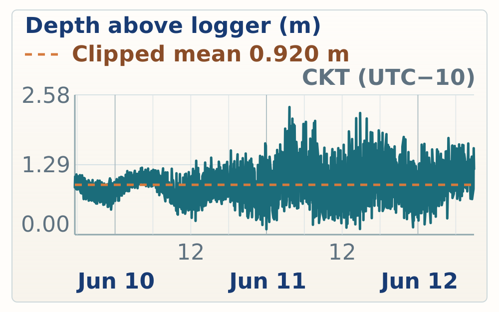
Tidal reference
Site evidence
June 9 was the first full Mitiaro recorder day. Work began with a temporary tide-gauge deployment at Mitiaro Harbor, then moved through a morning makatea and reef-outcrop reconnaissance, a south-coast reddish-weathering check, and afternoon HS122 work at Teunu. The recorder notes document control points, sample labels, possible U-series targets, storm-affected boulders, a vegetated low-pool/ledge feature, and uncertainty over how to separate possible Holocene material from older reef limestone near sea level.
08:59-09:03
Overview
08:59 | MITIARO-20260609-RN-024
Temporary tide gauge was deployed at Mitiaro Harbor.
tide gauge deployed in Mitiaro Harbor.
Mitiaro Harbor tide gauge
Temporary tide gauge was deployed at Mitiaro Harbor.
09:03 | MITIARO-20260609-RN-023
The harbor tide-gauge rock is 191 cm below the concrete surface; the exact gauge reference point still needs datum check.
The tide gauge rock is 191 centimeters below the concrete surface at the harbor. We will need to offset, maybe by the midpoint we'll look up what the exact location of the measurement on the tide gauge, but the tide gauge is vertical right now. So where its measured is anywhere within that tide gauge.
Tide-gauge offset
The harbor tide-gauge rock is 191 cm below the concrete surface; the exact gauge reference point still needs datum check.
09:28-09:37
Overview
09:28 | MITIARO-20260609-RN-022
The outcrop includes V-shaped coral plates whose formation mechanism was unresolved in the field.
Still struggling to understand in what scenario we get these sort of V-shaped plates of coral.
V-shaped coral plates
The outcrop includes V-shaped coral plates whose formation mechanism was unresolved in the field.
09:30 | MITIARO-20260609-RN-021
Long straight to curvilinear micrite-like carbonate features may be mound caps, infill, or fractures; interpretation remains unresolved.
There's long kind of curvilinear features of what looks basically like pure micrite microcrystalline carbonate. I've seen these in a lot of places and I never really understand what they are. I'm wondering if it actually represents maybe the top of a mound, a large mound of coral and when that mound sort of stops being active and the encrusters and the endolists are to take over, they form this rind over the top. And now we've eroded through the entire thing and we're just seeing the side. Is that or some kind of crack that is infilled in the past? But sometimes it makes you think of a fault because they can be so long and straight.
Curvilinear micrite features
Long straight to curvilinear micrite-like carbonate features may be mound caps, infill, or fractures; interpretation remains unresolved.
09:32 | MITIARO-20260609-RN-020
The base of the outcrop contains many large in-situ corals.
The base of the outcrop here has many very large in situ corals.
Large in-situ corals
The base of the outcrop contains many large in-situ corals.
09:37 | MITIARO-20260609-RN-019
The team began its first recorded makatea traverse on Mitiaro near the morning outcrop stop.
The team explores their first makatea on Mitiaro.
First Mitiaro makatea
The team began its first recorded makatea traverse on Mitiaro near the morning outcrop stop.
12:23
Overview
12:23 | MITIARO-20260609-RN-018
The lower south-coast Mitiaro outcrop is reddish and fades upward without a sharp top; weathering or preservation cause remains uncertain.
There's a strange reddishness to the lower part of the outcrop here in the southern tip of Mitiaro. I don't know, maybe it's suggestive of different weather horizons or maybe it's you know, some kind of surface that whether in a different way or maybe it's just a preservation we have in the south coast. There's no obvious top to the red. It just kind of fades away.
South-coast reddish outcrop
The lower south-coast Mitiaro outcrop is reddish and fades upward without a sharp top; weathering or preservation cause remains uncertain.
14:47-16:19
Overview
14:47 | MITIARO-20260609-RN-017
HS122 Teunu or new-site marker was recorded; the exact suffix remains uncertain from the audio.
HS 122 T. or new.
HS122 Teunu start
HS122 Teunu or new-site marker was recorded; the exact suffix remains uncertain from the audio.
14:55 | MITIARO-20260609-RN-016
Coral- and bioencruster-bearing boulders sit landward of spurs and grooves; in-place versus storm-transport origin remains unresolved.
Higher than the spurs and grooves towards land up up against the trees there are conspicuous boulders where do they tell if they're in place or if they're ripped up from the reefs below they're full of corals and bio encrusters.
Coral-bearing boulders
Coral- and bioencruster-bearing boulders sit landward of spurs and grooves; in-place versus storm-transport origin remains unresolved.
14:57 | MITIARO-20260609-RN-015
The exposed coast is likely affected by large storms, and the boulders were interpreted as probable modern storm-berm material.
Given where we are on the island, this is the coastline that's hit by large storms. I strongly suspect these boulders are actually some sort of modern storm berm.
Probable storm berm
The exposed coast is likely affected by large storms, and the boulders were interpreted as probable modern storm-berm material.
15:03 | MITIARO-20260609-RN-014
A near-constant ledge level around a vegetated low suggests a pool-like feature on the reef flat.
The somewhat constant level to the ledge around this low feature full of vegetation is suggestive of some kind of pool, you know, a low pool on the reef flat.
Vegetated pool ledge
A near-constant ledge level around a vegetated low suggests a pool-like feature on the reef flat.
15:06 | MITIARO-20260609-RN-012
Photos record blocky micrite or microcrystalline calcite, small grains, and lighter platy or elongate carbonate in the ledge rock.
Some photographs of the rock. That makes up the ledge. They're sort of blocky. Micro crystalline. Calcites, small grains. And some platy. More elongate. Lighter colored carbonate.
Ledge lithology photos
Photos record blocky micrite or microcrystalline calcite, small grains, and lighter platy or elongate carbonate in the ledge rock.
15:06 | MITIARO-20260609-RN-013
Second photo note repeats the ledge-fabric observation: blocky micrite or microcrystalline calcite plus lighter platy or elongate carbonate.
Some photographs of the rock that makes up the ledge. There's sort of lucky microcrystalline, calcite, small grains, and some platy, more elongate, lighter colored carbonate.
Duplicate ledge fabric note
Second photo note repeats the ledge-fabric observation: blocky micrite or microcrystalline calcite plus lighter platy or elongate carbonate.
15:07 | MITIARO-20260609-RN-011
Storm overwash ponding was raised as one possible explanation for downward erosion through limestone and a ledge around the pool.
An alternative explanation is that this is actually an erosional feature. Maybe not active today because there's a lot of vegetation in the bottom but from the early Holocene. Storm waves crash over the cliff, water pools up at this surface and starts to sort of eat downwards through the limestone leaving this ledge on the edge of the pool.
Pool ledge hypothesis
Storm overwash ponding was raised as one possible explanation for downward erosion through limestone and a ledge around the pool.
15:10 | MITIARO-20260609-RN-010
At Teunu, the team sampled the outcrop while a recently upturned storm block exposed a fresh white surface.
The team samples and studies the outcrop here at Teunu. And in the foreground, the white surface of a recently upturned storm block is visible.
Teunu storm block
At Teunu, the team sampled the outcrop while a recently upturned storm block exposed a fresh white surface.
HS122 Teunu drone overview
DJI high-oblique overview frames showing the HS122 Teunu reef-flat, makatea edge, coastal cliff, storm-block, and vegetated ledge context from the afternoon flight.
15:45 | MITIARO-20260609-RN-009
Near sea level, the boundary between possible Holocene material and older reef limestone was unclear, so the dateable sample remains interpretive.
Down near sea level it's really difficult to tell where the Holocene may end and where FIDB begins. Jacky's sampled the Porites is clearly draping the groove. Could be early Holocene. The sample looks really good. We'll take it to date but it could also be just preferentially sticking out of the FIDB outcrop as it weathers away.
HS122 Holocene uncertainty
Near sea level, the boundary between possible Holocene material and older reef limestone was unclear, so the dateable sample remains interpretive.
15:50 | MITIARO-20260609-RN-008
Jacky and Emily discussed possible histories for a sample collected for U-series dating.
Jacky and Emily discuss the possible histories of a sample collected for U-series.
HS122 U-series discussion
Jacky and Emily discussed possible histories for a sample collected for U-series dating.
16:09 | MITIARO-20260609-RN-007
HS122 GCP1 was recorded.
HS-122, GCP-1.
HS122 GCP1
HS122 GCP1 was recorded.
16:13 | MITIARO-20260609-RN-006
HS122 GCP12 was recorded.
HS-122GCP-12.
HS122 GCP12
HS122 GCP12 was recorded.
16:14 | MITIARO-20260609-RN-005
A small perched pool near the cliff was photographed as a possible analogue for larger pool formation; interpretation remains tentative.
A photograph of a little perched pool near the cliff. This is one model for how I think maybe the larger pool formed if it formed at the elevation it currently is relative to sea level.
Perched pool analogue
A small perched pool near the cliff was photographed as a possible analogue for larger pool formation; interpretation remains tentative.
16:15 | MITIARO-20260609-RN-004
HS122 GCP3 was recorded.
HS-122 GCP-3.
HS122 GCP3
HS122 GCP3 was recorded.
16:16 | MITIARO-20260609-RN-003
HS122 sample B was recorded.
HS122 sample B.
HS122 sample B
HS122 sample B was recorded.
16:18 | MITIARO-20260609-RN-002
HS122 GCP4 was recorded.
HS122GCP4.
HS122 GCP4
HS122 GCP4 was recorded.
16:19 | MITIARO-20260609-RN-001
HS122 GCP7 was recorded.
HS-122GCP-7.
HS122 GCP7
HS122 GCP7 was recorded.
| Site ID | Height (m above mean sea level) | Vertical position | Vertical accuracy | Vertical precision | Points | Notes |
|---|---|---|---|---|---|---|
| Mitiaro Harbor | 0.913 m | 14.413 m | 0.147 m | 0.007 m | 100 | No note recorded. |
| Tide gauge Mitiaro | 0.980 m | 14.480 m | 0.128 m | 0.005 m | 100 | Dock above tide gauge, where rope reaches dock surface |
| GCP3 HS122 | 6.875 m | 20.375 m | 0.394 m | 0.029 m | 100 | Mitiaro first site. Teunu |
| GCP3 | 7.052 m | 20.552 m | 0.180 m | 0.005 m | 100 | HS122 teunu |
| GCP3 | 7.077 m | 20.577 m | 0.128 m | 0.005 m | 100 | No note recorded. |
| GCP3 | 7.180 m | 20.680 m | 0.107 m | 0.002 m | 100 | No note recorded. |
| HS122B | 6.351 m | 19.851 m | 0.095 m | 0.003 m | 100 | Sample Teunu Mitiaro 🪸 |
| HS122C | 5.971 m | 19.471 m | 0.083 m | 0.004 m | 100 | No note recorded. |
| HS122C | 8.770 m | 22.270 m | 0.073 m | 0.003 m | 100 | Teunu from side of highest pillar |
| GCP12 | 6.316 m | 19.816 m | 0.075 m | 0.004 m | 100 | HS122 |
| GCP4 | 7.316 m | 20.816 m | 0.073 m | 0.002 m | 100 | No note recorded. |
| GCP1 | 6.615 m | 20.115 m | 0.070 m | 0.003 m | 100 | Let’s go Mets! |
| HS122D | 4.885 m | 18.385 m | 0.069 m | 0.012 m | 100 | No note recorded. |
| GCP1 | 6.817 m | 20.317 m | 0.064 m | 0.002 m | 100 | No note recorded. |
| GCP8 | 7.913 m | 21.413 m | 0.064 m | 0.004 m | 100 | No note recorded. |
| HS122A | 5.668 m | 19.168 m | 0.062 m | 0.006 m | 100 | No note recorded. |
| HS122F | 2.241 m | 15.741 m | 0.061 m | 0.003 m | 100 | In groove near sea |
| HS122E | 1.314 m | 14.814 m | 0.075 m | 0.005 m | 100 | Very close to modern High tide |
| HS122 waterline modern shore | 0.272 m | 13.772 m | 0.070 m | 0.007 m | 100 | No note recorded. |
| Cook Atlas GPS point 366 | 9.696 m | 23.196 m | 1.726 m | 0.214 m | 100 | No note recorded. |
| GCP 2 along road, rock and log | 7.265 m | 20.765 m | 0.463 m | 0.038 m | 100 | No note recorded. |
| GCP 3 along road, after pine patch, little tree on bare ground | 6.055 m | 19.555 m | 0.439 m | 0.122 m | 100 | Past Australian pine We stopped at a little tree Poll on a flat rock |
| GCP 4 along road, before higher canopy, on driftwood right side of street | 5.500 m | 19.000 m | 0.223 m | 0.016 m | 100 | Up the road a piece Driftwood on makatea Shaft of evening light |
| GCP 5th point along road, next to patch of palm trees, bent road | 3.526 m | 17.026 m | 1.397 m | 0.081 m | 100 | No note recorded. |
| HS122G | 5.058 m | 18.558 m | 2.414 m | 0.014 m | 100 | Makatea road coral sample |
Tidal reference
Site evidence
June 10 focused on Mitiaro's Te Rotonui and Parava sector, then ended with an afternoon HS124 stop on the southwest reef flat. After a vehicle tie-rod repair, the team worked HS123 near the road toward Te Rotonui and close to Stoddart's Parava profile area. Recorder notes document angular carbonate sand over coral-rich outcrop, possible Holocene notch fill versus older wall rock, sample and GCP control, and explicit uncertainty over the Holocene to MIS 5e boundary in the grooves. Later stops recorded Te Rotonui Road coral/encruster samples and possible patch-reef or bommie paleohighs, a backhoe-cut sand or dune-material exposure, and HS124 reef-flat/spur observations. At HS124, wind setup covered microatolls that may normally mark low-water level, spur tops carried large coral colonies, and the limestone weathering was described as sharper and more microkarstic than the morning site. The HISEAS CSV adds 30 Mitiaro measurements for HS123, Te Rotonui Road, Via Nauri, and HS124.
10:26
Overview
10:26 | MITIARO-20260610-RN-028
Vehicle tie-rod repair delayed the first outcrop stop.
Before getting to our first outcrop this morning we needed to repair the vehicle. We had noticed a wobble while driving and then by the time we stopped the tire had come detached from the tire rot on the right side. The fix was essentially to relieve the pressure on an alligator clip high up, sort of closer to the body of the car and then feed the tire rod back into the part that comes off the tire and rotate until it was fully threaded again.
Vehicle tie-rod repair
Vehicle tie-rod repair delayed the first outcrop stop.
10:27-11:15
Overview
10:27 | MITIARO-20260610-RN-027
HS123 began near Stoddart's Parava transect area on the road toward Te Rotonui.
HS123 this is about where Stoddart did his parava transect we're gonna call it Te Rotonui it's the name of the road that units towards the large lake.
HS123 Te Rotonui start
HS123 began near Stoddart's Parava transect area on the road toward Te Rotonui.
10:36 | MITIARO-20260610-RN-026
The top of the section has angular carbonate sand compared in the field with perched beach or eolianite-like sand on Mauke.
At the top of the section, there is a layer of sand. Likely what Stoddart was calling a perched beach. It's very reminiscent of the eolianites on Mauke. It's not what you'd think of in a textbook as a classic eolianite where you have very constant grain sizes and it's all... I mean this is very angular. There's no boulders or cobbles. It's still sand, but it's quite angular. Probably eolianite forming during high-energy sort of storm events.
HS123 perched sand layer
The top of the section has angular carbonate sand compared in the field with perched beach or eolianite-like sand on Mauke.
10:39 | MITIARO-20260610-RN-025
Coral-rich outcrop lies below the sand layer, with small fist-size corals and no massive colonies noted.
The top of the outcrop here below the sand layer is coral. Lots of coral. So we're going to be able to put a whole new temperature between the corals. No massive corals. Really small, sort of fist size. A little bit bigger.
HS123 coral below sand
Coral-rich outcrop lies below the sand layer, with small fist-size corals and no massive colonies noted.
10:40 | MITIARO-20260610-RN-024
Additional photos documented the sand layer at HS123.
More images of the sand layer.
HS123 sand-layer photos
Additional photos documented the sand layer at HS123.
10:43 | MITIARO-20260610-RN-023
A photo recorded vertically oriented Halimeda-like plates or platy carbonate fabric; identification needs photo check.
photograph of an interesting sort of vertical orientation to the Halimeda plates.
HS123 Halimeda plates
A photo recorded vertically oriented Halimeda-like plates or platy carbonate fabric; identification needs photo check.
10:48 | MITIARO-20260610-RN-022
The reef-flat traverse considered the high-notch and path relationship at HS123.
Billy walks the reef flat pondering the high knots in a path.
HS123 reef-flat traverse
The reef-flat traverse considered the high-notch and path relationship at HS123.
10:50 | MITIARO-20260610-RN-021
Corals at the right elevation and context were noted as possible early Holocene notch fill.
Photo of corals growing at the right elevation and in the context that suggests they could be filling in the notch in the early Holocene.
HS123 notch-fill corals
Corals at the right elevation and context were noted as possible early Holocene notch fill.
11:03 | MITIARO-20260610-RN-020
A possible Holocene contact near the low point of the elevated tidal notch separates vertically oriented corals below from more haphazard coral fabric above.
It really seems like there's a Holocene contact that comes to about the low point of the tidal notch of the elevated notch where all the coral colonies are growing vertically, sort of filling a combination space, attaching to the rock. And then above that it starts to be a bit more haphazardly orientation of the corals. The corals get a little bit smaller. Again, this suggests that these are Holocene corals growing in a notch.
HS123 Holocene contact
A possible Holocene contact near the low point of the elevated tidal notch separates vertically oriented corals below from more haphazard coral fabric above.
11:05 | MITIARO-20260610-RN-019
Sand filling the upper notch could belong to the older outcrop or be later notch infill.
photograph of the sand filling the upper part of the notch unclear if this is part of the 5e outcrop or something that has filled into the notch later.
HS123 notch sand fill
Sand filling the upper notch could belong to the older outcrop or be later notch infill.
11:07 | MITIARO-20260610-RN-018
The boundary between possible Holocene fill and MIS 5e wall rock was explicitly uncertain, especially back in grooves.
It's really challenging to decide where the Holocene ends and where MIS-5E begins. It makes this interpretation tough. There are large corals that could be part of the wall rock or they could be part of Holocene and film. Down low near the reef flat, it's easier to convince yourself that as you work way back into the grooves, it becomes more complicated for sure.
HS123 Holocene boundary
The boundary between possible Holocene fill and MIS 5e wall rock was explicitly uncertain, especially back in grooves.
11:11 | MITIARO-20260610-RN-017
Horizontal cracks cut through large coral colonies, arguing against a simple erosion-and-recolonization surface.
There's been some discussion of the cracks that seem to have worked their way through the outcrop horizontally in a few places. Are these paleo surfaces or not? But the two photos I just took are a good example showing that the cracks can go right through large coral colonies, which is not what you'd expect if the surface was caused by erosion and then re-colonized later.
HS123 cracks through corals
Horizontal cracks cut through large coral colonies, arguing against a simple erosion-and-recolonization surface.
11:15 | MITIARO-20260610-RN-016
Photos recorded large coral colonies on the flat behind the spurs at HS123.
Some photos of large coral colonies up on the flat behind the sperps.
HS123 flat-back corals
Photos recorded large coral colonies on the flat behind the spurs at HS123.
HS123 Te Rotonui and Parava drone overview
DJI high-oblique overview frames showing the HS123 Te Rotonui/Parava pocket, reef-flat edge, road context, coastline, and makatea vegetation from the midday flight.
12:26-13:03
Overview
12:26 | MITIARO-20260610-RN-015
HS123 GCP12 was recorded.
HS-123 GCP-12.
HS123 GCP12
HS123 GCP12 was recorded.
12:27 | MITIARO-20260610-RN-014
HS123 GCP8 was recorded.
HS-123 GCP-8.
HS123 GCP8
HS123 GCP8 was recorded.
12:32 | MITIARO-20260610-RN-013
A short HS123 field audio marker was made; the sample or control suffix was not spoken.
Just 123.
HS123 marker
A short HS123 field audio marker was made; the sample or control suffix was not spoken.
12:36 | MITIARO-20260610-RN-012
HS123 GCP4 was recorded.
HS123 and GCP4.
HS123 GCP4
HS123 GCP4 was recorded.
12:40 | MITIARO-20260610-RN-011
HS123 GCP1 was recorded.
HS123GCP1.
HS123 GCP1
HS123 GCP1 was recorded.
13:01 | MITIARO-20260610-RN-010
HS123C was sighted 104 cm above the bottom of the GPS pole.
HS123C was sighted to 104 centimeters above the bottom of the GPS pole.
HS123C elevation sight
HS123C was sighted 104 cm above the bottom of the GPS pole.
13:03 | MITIARO-20260610-RN-009
HS123D was sighted 170 cm above the GPS point.
HS123D was sited to 170 centimeters above the GPS point.
HS123D elevation sight
HS123D was sighted 170 cm above the GPS point.
13:30-14:16
Overview
13:30 | MITIARO-20260610-RN-008
HS123G is a small coral with encrusters; pieces were taken for Emily and Blake.
HS123G. It's a small coral surrounded by encrusters. Emily's taking a piece that's about half coral, half encruster. Blake's gonna take a piece that's mostly encrusters with a little bit of the coral.
HS123G encruster sample
HS123G is a small coral with encrusters; pieces were taken for Emily and Blake.
13:37 | MITIARO-20260610-RN-007
Roadside sand and higher rocky patches may mark patch-reef or bommie paleohighs on the reef flat; this remains provisional.
Along the road there are patches of sand and then rocky patches, off into the side of the rocky patches which tend to be a little bit higher. There are boulders in the makatera in the field to the side. Suggestive that maybe the rocky parts here were actually paleo highs like little bommies and we're walking across a reef flat with a lot of tiny little patch reefs and when they made the road they just cleared off as much as they could. The photograph kind of shows this.
Te Rotonui Road highs
Roadside sand and higher rocky patches may mark patch-reef or bommie paleohighs on the reef flat; this remains provisional.
14:16 | MITIARO-20260610-RN-006
A backhoe-cut exposure showed a cross-section through dune or sand material.
photo of a cross-section through the dune material where a backhoe cleared it out a while ago.
Dune-material cross-section
A backhoe-cut exposure showed a cross-section through dune or sand material.
15:53-16:48
Overview
15:53 | MITIARO-20260610-RN-005
Wind and waves were pushing water across the reef flat, submerging microatolls that elsewhere mark low-water level.
The wind and waves are really pushing a lot of water to the reef flat. You can see in the foreground of one of these photographs the microatolls with colored rims and the stony, non-colorful top. In other places in calm environments we've seen that these are basically the low-water mark. And here they're quite under water. Wonder if it's just the wind pushing water up onto the shelf.
HS124 submerged microatolls
Wind and waves were pushing water across the reef flat, submerging microatolls that elsewhere mark low-water level.
15:56 | MITIARO-20260610-RN-004
Large massive coral colonies were noted at the tops of HS124 spurs.
Large coral colonies at the top of the spur. Quite a few of them. Which feels distinct from where we work this morning. The tops of the spurs were quite encrusted. The corals that were there, they were massive colonies. I feel like we're a little bit lower here. So I wonder if this side, the spurs are actually not filling as much of the accommodation space.
HS124 spur-top corals
Large massive coral colonies were noted at the tops of HS124 spurs.
15:57 | MITIARO-20260610-RN-003
HS124 rock was described as sharper and more microkarstic than the earlier site, with a distinct walking surface.
It's also worth mentioning that the way the rock weathers here is distinct from the summer. It's a lot sharper and microkarst. If you walk on it, you can feel a little bit springy.
HS124 sharp microkarst
HS124 rock was described as sharper and more microkarstic than the earlier site, with a distinct walking surface.
HS124 southwest reef-flat drone overview
DJI high-oblique overview frames showing the HS124 southwest reef-flat, spur tops, coastal notch, reef edge, and wind-setup context from the afternoon flight.
16:46 | MITIARO-20260610-RN-002
HS124 GCP8 was recorded.
HS124GCP8.
HS124 GCP8
HS124 GCP8 was recorded.
16:48 | MITIARO-20260610-RN-001
HS124 GCP3 and likely HS124B were recorded at the same position; confirm the sample suffix against photos or the HISEAS ledger.
HS1242. GCP3. HS1242. HS1242. HS1242. HS1242. HS1242. HS1242. HS1242. HS1242. HS1242. HS1242. HS1242. HS1242. HS1242. HS1242. HS1242. HS1242. HS1242. HS1242. HS1242. HS1242. HS1242. HS1242. HS1242. HS1242. HS1242. HS1242. HS1242.
HS124 GCP3 and B
HS124 GCP3 and likely HS124B were recorded at the same position; confirm the sample suffix against photos or the HISEAS ledger.
| Site ID | Height (m above mean sea level) | Vertical position | Vertical accuracy | Vertical precision | Points | Notes |
|---|---|---|---|---|---|---|
| HS123B | 5.145 m | 18.645 m | 0.066 m | 0.003 m | 100 | Te Rotonui coral sample |
| HS123A | 6.684 m | 20.184 m | 0.064 m | 0.003 m | 100 | Same position as GCP8,Te Rotonui coast |
| GCP8 | 6.696 m | 20.196 m | 0.063 m | 0.003 m | 100 | Same pos as HS123A |
| GCP12 | 5.821 m | 19.321 m | 0.062 m | 0.003 m | 100 | No note recorded. |
| GCP3 | 6.447 m | 19.947 m | 0.065 m | 0.003 m | 100 | No note recorded. |
| GCP1 | 0.561 m | 14.061 m | 0.067 m | 0.002 m | 100 | On raised reef flat |
| Modern waterline on reef flat | -0.109 m | 13.391 m | 0.165 m | 0.013 m | 100 | No note recorded. |
| HS123C elevation see note | 0.613 m | 14.113 m | 0.064 m | 0.003 m | 100 | Sited HS123C from this location in reef flat. Coral sample is from the mid Holocene notch and is at the height of the split in the survey rod. So elevation is up from here the JT of the bottom half of pole ~1m |
| HS123D | 0.049 m | 13.549 m | 0.075 m | 0.003 m | 100 | Coral sample is sighted from here, located Billy’s eye level just about EXACTLY, up from bottom of pole. Used leveling app on iPhone to sight. Pretty good I think. Trust me. |
| HS123E | 7.295 m | 20.795 m | 0.064 m | 0.002 m | 100 | No note recorded. |
| GCP4 | 6.290 m | 19.790 m | 0.070 m | 0.003 m | 100 | No note recorded. |
| GCP7 | 6.790 m | 20.290 m | 0.064 m | 0.003 m | 100 | No note recorded. |
| To Rotonui road, point 1 | 8.152 m | 21.652 m | 0.900 m | 0.020 m | 100 | No note recorded. |
| Te Rotonui Road | 7.221 m | 20.721 m | 0.404 m | 0.012 m | 100 | Karsted makatea, corals present |
| HS123F | 6.475 m | 19.975 m | 0.207 m | 0.026 m | 100 | Te Rotonui road coral sample |
| HS123G | 7.351 m | 20.851 m | 0.138 m | 0.014 m | 100 | Sample taken for Emalee and one for Blake (sm coral surrounded with encrusters) |
| HE123F | 6.847 m | 20.347 m | 0.124 m | 0.013 m | 100 | No note recorded. |
| Te Rotonui Road | 3.902 m | 17.402 m | 0.089 m | 0.005 m | 100 | No note recorded. |
| Te Rotonui shoreline | 1.147 m | 14.647 m | 1.591 m | 0.268 m | 100 | No note recorded. |
| GCP3 | 6.466 m | 19.966 m | 0.109 m | 0.004 m | 100 | HS124B sample also here |
| HS124B | 6.411 m | 19.911 m | 0.102 m | 0.003 m | 100 | GCp3 also here |
| HS124A | 6.511 m | 20.011 m | 0.092 m | 0.006 m | 100 | No note recorded. |
| HS124C | 5.907 m | 19.407 m | 0.083 m | 0.003 m | 100 | No note recorded. |
| GCP1 | 6.098 m | 19.598 m | 0.080 m | 0.016 m | 100 | No note recorded. |
| GCP8 | 6.562 m | 20.062 m | 0.073 m | 0.003 m | 100 | No note recorded. |
| GCP12 | 5.257 m | 18.757 m | 0.070 m | 0.003 m | 100 | No note recorded. |
| HS124D | 5.728 m | 19.228 m | 0.068 m | 0.003 m | 100 | No note recorded. |
| GCP4 | 6.680 m | 20.180 m | 0.069 m | 0.003 m | 100 | No note recorded. |
| HS124E | 5.784 m | 19.284 m | 0.070 m | 0.004 m | 100 | No note recorded. |
Schedule lock
Confirmed by Tangimama Harry for Thursday, June 11; Principal Mrs. Maora Murare was copied on the confirmation.
Tidal reference
Site evidence
June 11 was a shorter Mitiaro recorder day focused on HS125 near Chris's house beach and a late west-side revisit during energetic waves. At HS125, recorder notes and HISEAS rows 402-411 tie GCP8, GCP3, GCP4, GCP12, GCP1, the waterline, and HS125A-D/HS125B sample positions to a broad coral slope with lower spurs and a back-reef surface that may sit higher than the spur tops. A groove near sea level preserves a clast horizon with different weathering, but the field notes leave the Holocene versus MIS 5e boundary uncertain. The west-side return documented rapid sand movement under large southwest waves. HISEAS rows 412-414 and recorder notes mark recent highest sand from wave action, with the topmost sand described as nearly 5 m above the tidal datum and absent during the previous visit roughly 36 hours earlier. The high-sand observations support a possible perched-beach explanation for some dune-like sand in the context of higher early Holocene sea level and Stoddart's Mitiaro perched-beach descriptions, but the modern wave event shows that high-energy waves can move sand substantially without a cyclone.
14:43-14:54
Overview
14:43 | MITIARO-20260611-RN-012
HS125 GCP8 was recorded.
HS125GCP8.
HS125 GCP8
HS125 GCP8 was recorded.
14:46 | MITIARO-20260611-RN-011
HS125 was described as a broad coral slope toward the road, with lower spurs and a back-reef surface that may sit higher than the spurs.
At HS125 the spurs don't seem as tall as some of the spurs we've seen in other parts of the island and as a broad gentle slope of coral heading up towards the road it's covered by quite a bit of sand at the top but it does seem like the spurs are not the highest feature actually the back the back reef that's what it is seems a bit higher than a spur itself.
HS125 low-spur slope
HS125 was described as a broad coral slope toward the road, with lower spurs and a back-reef surface that may sit higher than the spurs.
14:46 | MITIARO-20260611-RN-010
HS125 GCP3 was recorded.
HS125GCP3.
HS125 GCP3
HS125 GCP3 was recorded.
14:47 | MITIARO-20260611-RN-009
The lower-spur, gently sloping HS125 pattern was compared with the Mauke Uriaata runway-end section, with the island/site memory flagged as uncertain.
This gently sloping pattern with lower spurs kind of near the airport matches our experience on moke at Yuri Ata if I'm remembering the right island but the section we did right at the end of the runway.
HS125 Uriaata analogue
The lower-spur, gently sloping HS125 pattern was compared with the Mauke Uriaata runway-end section, with the island/site memory flagged as uncertain.
14:49 | MITIARO-20260611-RN-008
HS125 GCP4 was recorded.
HS125GCP4.
HS125 GCP4
HS125 GCP4 was recorded.
14:51 | MITIARO-20260611-RN-007
Near sea level at HS125, a distinct clast horizon weathered differently from overlying rock and could be Holocene storm material; the Holocene versus MIS 5e boundary remains uncertain.
A few photographs showing me outcrop in a groove near sea level where again the difference between Holocene and Fivig is really hard to tell. It's the right of Jacky in the second photo. There's a distinct horizon of clasts that seem to be weathering out differently than the rocks above. It could be a Holocene storm when sea level was a little bit higher. Rocks above it and behind it are very different weathering profile.
HS125 clast horizon
Near sea level at HS125, a distinct clast horizon weathered differently from overlying rock and could be Holocene storm material; the Holocene versus MIS 5e boundary remains uncertain.
14:52 | MITIARO-20260611-RN-006
HS125 GCP12 was measured.
Billy is measuring HS125GCP 12.
HS125 GCP12
HS125 GCP12 was measured.
14:54 | MITIARO-20260611-RN-005
HS125 GCP1 was recorded.
HS125GCP1.
HS125 GCP1
HS125 GCP1 was recorded.
HS125 Chris's house drone overview
DJI high-oblique overview frames showing the HS125 Chris's house beach, low-spur reef-flat edge, broad back-reef slope, coastline, and makatea vegetation from the afternoon flight.
16:36-16:45
Overview
16:36 | MITIARO-20260611-RN-004
West-side waves had recently filled the beach with sand, with topmost sand measured about 5 m above the tidal datum.
Returning to the west side, there's a lot of energy in large waves today. It's clear that the beach has filled up since we got here. We're measuring at GPS point. We got the topmost sand that seems like it was recently placed. Almost five meters higher than the tidal datum. It's really impressive how much sand can move in and out just a few days. Without hurricanes, it's not even raining. It's just large waves coming off the southwest side today.
West-side recent sand
West-side waves had recently filled the beach with sand, with topmost sand measured about 5 m above the tidal datum.
16:40 | MITIARO-20260611-RN-003
Active waves were carving a small scarp near the outcrop, suggesting only slightly higher energy could drive sand up to the GPS points.
The waves today are carving a very small scarf right around where the outcrop revs away from maybe 2 meters beneath GPS It's easy to imagine just a little bit more energy and sand lapping all the way up to any GPS's.
Wave-cut sand scarp
Active waves were carving a small scarp near the outcrop, suggesting only slightly higher energy could drive sand up to the GPS points.
16:42 | MITIARO-20260611-RN-002
The high sand was treated as a possible perched-beach explanation for the dune-like sand, in the context of higher early Holocene sea level.
This is probably the best explanation for the sand that we were calling dunes. That started us right all along. She had never doubted him. Perched beach is a pretty good explanation. In the early Holocene, the sea level higher. So he's not so far-fetched to have beaches like the one just photographed. That show up maybe 10 meters above sea level today. Maybe even higher on windier sides of the islands.
Perched beach analogy
The high sand was treated as a possible perched-beach explanation for the dune-like sand, in the context of higher early Holocene sea level.
16:45 | MITIARO-20260611-RN-001
Plants near the west-side sand line appeared to have been hit hard by waves, possibly the previous night.
The plants suggested they were hit with waves pretty hard, maybe even last night.
Wave-struck plants
Plants near the west-side sand line appeared to have been hit hard by waves, possibly the previous night.
| Site ID | Height (m above mean sea level) | Vertical position | Vertical accuracy | Vertical precision | Points | Notes |
|---|---|---|---|---|---|---|
| HS125 Chris’s house GCP4 | 3.157 m | 16.657 m | 0.063 m | 0.002 m | 100 | GCP4 |
| GCP12 | 0.401 m | 13.901 m | 0.064 m | 0.002 m | 100 | No note recorded. |
| Waterline Chris’s beach | -0.061 m | 13.439 m | 0.064 m | 0.003 m | 100 | No note recorded. |
| GCP1 | 0.348 m | 13.848 m | 0.065 m | 0.003 m | 100 | No note recorded. |
| GCP8 | 4.848 m | 18.348 m | 0.076 m | 0.003 m | 100 | No note recorded. |
| HS125B | 5.288 m | 18.788 m | 0.071 m | 0.002 m | 100 | No note recorded. |
| GCP3 | 6.055 m | 19.555 m | 0.069 m | 0.003 m | 100 | Chris’s house |
| HS125D | 4.963 m | 18.463 m | 0.067 m | 0.002 m | 100 | No note recorded. |
| HS125C | 4.017 m | 17.517 m | 0.067 m | 0.003 m | 100 | No note recorded. |
| HS125A | 3.375 m | 16.875 m | 0.081 m | 0.004 m | 100 | No note recorded. |
| Highest sand from recent wave action | 4.762 m | 18.262 m | 0.153 m | 0.005 m | 100 | Seems this was delivered, and LOADS of sand along the beach, during the past 36 hours. We were here then and there was not this mass of sand. |
| Highest sand from recent wave action | 4.791 m | 18.291 m | 0.132 m | 0.008 m | 100 | No note recorded. |
| Real highest sand from recent waves | 5.403 m | 18.903 m | 0.082 m | 0.007 m | 100 | No note recorded. |
Flight timing
Tidal reference
| Site ID | Height (m above mean sea level) | Vertical position | Vertical accuracy | Vertical precision | Points | Notes |
|---|---|---|---|---|---|---|
| Tide gauge in Mitiaro harbor | 1.030 m | 14.530 m | 0.070 m | 0.004 m | 100 | Collection of tide gauge, surface of dock above tide gauge |
Flight timing